 Mon GéoSource
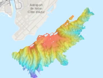
Bathymétrie - mer Ligure, aéroport de Nice (campagne FLUID3D-2, 2019) résolution 5 m
Bathymétrie du plateau au large de l'aéroport de Nice, en mer Ligure (campagne FLUID3D-2, 2019), au pas de 5 mètres. Les données ont été acquises par le sondeur SIMRAD ME70 (90 kHz, 81 faisceaux, ouverture 3 degrés) du N/O L'Europe.
Référence verticale : niveau moyen des mers observé.
Description de la campagne : DANO Alexandre, GARZIGLIA Sébastien (2019) FLUID3D-2 cruise, RV L'Europe, https://doi.org/10.17600/18000924
Simple
- Date ( Creation )
- 2021-07-12
- Identifier
- DOI:10.12770/03d6458c-8128-4400-982a-ba4652ef9d5b
- Presentation form
- Digital model
- Credit
- UMR Géoazur / Ifremer
08 98 22 45 89
- Maintenance and update frequency
- As needed
- Keywords ( Discipline )
-
- Bathymétrie
- Keywords ( Place )
-
- Méditerannée
- Mer Ligure
- Nice
- GEMET - INSPIRE themes, version 1.0 ( Theme )
-
- Altitude
- GEMET - Concepts, version 3.1 ( Theme )
-
- Fond marin
- Morphologie sous-marine
- Thèmes Sextant ( Theme )
-
- /Milieu physique/Bathymétrie/MNT
- Use limitation
- CC BY. Licence Creative Commons Attribution 4.0 International https://creativecommons.org/licenses/by/4.0/
- Use limitation
- Ne pas utiliser pour la navigation
- Access constraints
- Other restrictions
- Use constraints
- License
- Other constraints
- Pas de restriction d'accès public
- Spatial representation type
- Grid
- Distance
- 5 m
- Denominator
- 10000
- Metadata language
- Françaisfr
- Character set
- UTF8
- Topic category
-
- Elevation
- Environment description
- Version 6.2 (Build 9200) ; Esri ArcGIS 10.8.1.14362
))
- Reference system identifier
- EPSG / WGS84 / WORLD MERCATOR (EPSG 3395) latitude 43,6°N / 8.2.6
- Number of dimensions
- 2
- Dimension name
- Column
- Dimension size
- 799
- Resolution
- 5.000000 m
- Dimension name
- Row
- Dimension size
- 694
- Resolution
- 5.000000 m
- Cell geometry
- Area
- Transformation parameter availability
- Yes
- Checkpoint Availability
- No
Center point
- Point in Pixel
-
- Center
- Distribution format
-
-
Jeu de données Raster
()
-
Jeu de données Raster
()
- OnLine resource
- DOI du jeu de données ( WWW:LINK )
- OnLine resource
- Campagne FLUID3D-2 ( WWW:LINK )
- Protocol
- COPYFILE
- Name
- FLUID3D2_5m_BATHY
- OnLine resource
- FLUID3D2_5m_BATHY ( OGC:WMS )
- Hierarchy level
- Dataset
- Statement
-
Traitement automatique et manuel des données à l’aide du logiciel GLOBE (développé par l'Ifremer).
Aucune correction de marée. La référence verticale du jeu de données est le niveau moyen des mers observé.
- Content type
- Image
- Descriptor
- Band_1
- Maximum value
- -8.46
- Minimum value
- -444.600006
- Bits per value
- 32
- File identifier
- 03d6458c-8128-4400-982a-ba4652ef9d5b XML
- Metadata language
- Françaisfr
- Character set
- UTF8
- Hierarchy level
- Dataset
- Hierarchy level name
- dataset
- Date stamp
- 2022-04-29T08:57:57.476Z
- Metadata standard name
- ISO 19115:2003/19139 - SEXTANT
- Metadata standard version
- V. 1.2
Overviews
Spatial extent
Provided by
