 Mon GéoSource
Oceanographic cruise - NOURMED (Mediterranean's nursery)
As part of the implementation of the monitoring programme of the Marine Strategy Framework Directive (MSFD), the monitoring of demersal fish and cephalopods in coastal soft environments was deemed a priority. Annual observation campaigns of coastal nurseries on soft bottoms were carried out by the Laboratoire Halieutique Méditerranée of the Ifremer station in Sète.
The objectives of these campaigns are
1. To evaluate the density, biomass and distribution of fish and cephalopods by trawling, in particular benthic and demersal juveniles (red mullet, gurnard). To do this, around one hundred standardised trawl surveys were carried out over the entire coastal strip of the Gulf of Lion situated between 5m and 40m depth.
2. To systematically measure the size of the individuals collected in order to characterise the importance of the nursery function in the areas observed and to better understand the population dynamics of local species.
3. To gain a better understanding of the coastal zone ecosystem by systematically identifying all the species encountered (including benthic and pelagic invertebrates other than fish and cephalopods), the macro-waste observed and by characterising their hydrological habitats (CTD, oxygen, fluorescence, pH, turbidity, etc.).
Simple
- Date ( Publication )
- 2022-02-10
- Identifier
- 10031f79-24e5-40af-ba00-c7d2e543b042
- Presentation form
- Digital profile
- Credit
- IFREMER
- Status
- On going
- Maintenance and update frequency
- Annually
- Keywords ( Theme )
-
- Fish populations
- Nurseries
- Coastal habitat
- Trawl
- GEMET - INSPIRE themes, version 1.0 GEMET - INSPIRE themes, version 1.0 ( Theme )
-
- Environmental monitoring facilities
- Sous-regions marines Sous-regions marines ( Place )
-
- /Metropolitan France/Western Mediterranean
- Thèmes Sextant Thèmes Sextant ( Theme )
-
- /Human Activities/Oceanographical Cruises
- SIH - Façade maritime SIH - Façade maritime ( Theme )
-
- Méditerranée
- SIH - Types de jeu de données SIH - Types de jeu de données ( Theme )
-
- /Observed Data/Campaigns
- Thématiques - SIMM Thématiques - SIMM ( Theme )
-
- /Environmental Status/Species
- /Uses and Human Activities/Fisheries and aquaculture
- Type de jeux de donnée ODATIS Type de jeux de donnée ODATIS ( Theme )
-
- /in-situ observations/Sea cruises
- Cadre Réglementaire - SIMM Cadre Réglementaire - SIMM ( Theme )
-
- Directive Cadre Stratégie pour le Milieu Marin (DCSMM)
- Access constraints
- Restricted
- Unique resource identifier
- https://doi.org/10.18142/296
- Association Type
- Cross reference
- Initiative Type
- Platform
- Metadata language
- fr
- Character set
- UTF8
- Topic category
-
- Oceans
- Begin date
- 2018-08-31
))
- Supplemental Information
-
Financers :
IFREMER
Europe
Direction des Pêches Maritimes et de l'Aquaculture (DPMA)
- Distribution format
-
-
(
)
-
(
)
- OnLine resource
- Population and community indices from fisheries monitoring cruises in which Ifremer participates ( WWW:LINK )
- OnLine resource
- Access to SIH fisheries cruises data ( WWW:LINK )
- OnLine resource
-
campagnes_NOURMED_01
(
OGC:WMS
)
Campagnes NOURMED
- OnLine resource
- Coastal nurseries campaign report. NOURMED Campaign 2019 ( WWW:LINK )
- OnLine resource
- Coastal nurseries campaign report. NOURMED Campaign 2018 ( WWW:LINK )
- Hierarchy level
- Dataset
Conformance result
- Date ( Creation )
- 2012-01-16
- Explanation
- Not rated
- Pass
- No
- Statement
-
The adoption in 2008 of the Marine Strategy Framework Directive (MSFD) recommends that Member States adopt an ecosystem-based approach to the management of marine environments. The monitoring of demersal fish and cephalopods in soft coastal environments has been set up on the various maritime fronts via permanent and operational monitoring, based on a series of recurrent fishing campaigns carried out in depths of less than 40 metres.
No monitoring of this type existed in the Mediterranean before 2018, and the NOURMED campaign demonstrated that such monitoring was feasible and made it possible to achieve the expected monitoring objectives: to collect the data needed to calculate the Good Ecological Status (GES) indicators through the use of standardised sampling of benthic and demersal populations (invertebrates and commercial/non-commercial fish).
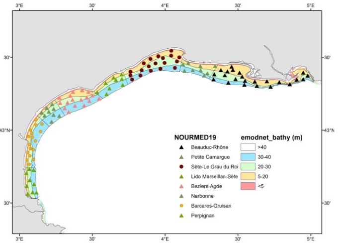
The campaign aims to sample the main trawlable coastal areas of fisheries interest in the Gulf of Lion. It consists of a systematic observation of the entire coastal strip of the Gulf of Lion in 5m and 40m, from Port-Vendres to Port du Bouc.
• Sampling plan(s) :
The observations are stratified into three bathymetric zones (5-20m, 20-30m, 30-40m) and eight geographical sectors: Perpignan, Barcares-Gruisan, Narbonne, Béziers-Agde, Lido Marseillan-Sète, Sète-Le Grau du Roi, Petite Camargue, Golfe de Beauduc-embouchure Rhône It therefore aims to sample the main trawlable coastal areas of fishing interest in the Gulf of Lion by means of a balanced coverage of around one hundred standardised trawls.
• Precision on the type of data:
The catches are made with a beam trawl 3m wide and 50cm vertical opening used for 15min at 2kt. The stretched mesh size of the net pocket is 20mm to allow the capture of juveniles.
The distance travelled during each trawling operation is between 1 and 1.4 km which corresponds to the distance expected for a 15 min trawl at 2kt.
After each trawl, the team sorted and weighed and counted all species collected, as well as measuring all fish and several invertebrate species (including the main cephalopods). The macro-waste hauled up is also identified, weighed and characterised. Finally, numerous samples are taken for further manipulation or identification on return to the laboratory.
After each trawl, a hydrological station is also carried out with measurements of temperature, conductivity, density, oxygen, pH, turbidity, radiance and fluorescence along the water column via a bathysonde. These measurements allow the detection of halo or thermoclines and the measurement of their depth, as well as the percentage of dissolved oxygen.
Continuous use of a pocket ferrybox to characterise the water masses encountered. This device carries out automated measurements of hydrological conditions (temperature, conductivity, density, oxygen, pH, turbidity) and chlorophyll pigments encountered (total fluorescence and at different wavelengths) in surface waters (at a depth of 3m)
• Parameter(s) observed or measured :
- Number of individuals, weight per species, size structure.
- Bathysonde, Trawling, Pocket ferrybox
• Resolution of parameter(s) :
By fishing operation, systematic analysis of scientific fishing catches
• Format(s):
The available data exist in the following format: csv
- File identifier
- 0f7df302-3bca-4390-abd6-0010fb476cc7 XML
- Metadata language
- fr
- Character set
- UTF8
- Parent identifier
- 99e16a35-8090-4897-aa2b-c5c0951aabea 99e16a35-8090-4897-aa2b-c5c0951aabea
- Hierarchy level
- Series
- Date stamp
- 2022-07-20T14:43:47.422Z
- Metadata standard name
- ISO 19115:2003/19139 - SEXTANT
- Metadata standard version
- 1.0
Overviews
Spatial extent
Provided by
