 Mon GéoSource
Oceanographic cruise - CGFS (Channel Ground Fish Survey) - Channel North Sea
CGFS cruise aims to collect basic data to estimate the status of fisheries resources, by direct assessment of stock abundance and distribution, along with biological sampling of commercial catches.
The CGFS campaign is carried out within the framework of this programme in the European project Contractualisation of Basic Fishery Data Collection (DCF). The abundance indices collected during this campaign are used by the ICES international working group "Demersal fisheries of the North Sea, Eastern Channel and Skagerrak" and complement the data from the English "Beam Trawl Survey" for the "Flatfish" working group.
Simple
- Date ( Publication )
- 2022-04-27
- Identifier
- FR-DCSMM-PDS-CGFS
- Presentation form
- Digital profile
- Credit
- IFREMER
- Status
- On going
- Maintenance and update frequency
- Annually
- Keywords ( Theme )
-
- English Channel
- Population indices
- Demersal, pelagic, cephalopods, crustaceans, benthos
- Habitats
- Trawling
- Fishery resources
- Distribution of stocks
- Abundance
- Environmental parameters
- Plankton
- Larvae
- MSFD monitoring
- GEMET - INSPIRE themes, version 1.0 GEMET - INSPIRE themes, version 1.0 ( Theme )
-
- Environmental monitoring facilities
- Sous-regions marines Sous-regions marines ( Place )
-
- /Metropolitan France/Channel-North Sea
- DCSMM : Type d'espace concerné DCSMM : Type d'espace concerné ( Theme )
-
- Pas d'espace particulier concerné
- DCSMM : Descripteurs DCSMM : Descripteurs ( Theme )
-
- D3: Commercially Exploited Species
- DCSMM : Méthodes de recueil des données DCSMM : Méthodes de recueil des données ( Theme )
-
- Observation par point
- Interprétation de cartographies
- Observation directe
- Piégeage, capture
- Thèmes Sextant Thèmes Sextant ( Theme )
-
- /Human Activities/Oceanographical Cruises
- SIH - Types de jeu de données SIH - Types de jeu de données ( Theme )
-
- /Observed Data/Campaigns
- SIH - Façade maritime SIH - Façade maritime ( Theme )
-
- Manche - Mer du Nord
- Cadre Réglementaire - SIMM Cadre Réglementaire - SIMM ( Theme )
-
- Directive Cadre Stratégie pour le Milieu Marin (DCSMM)
- Thématiques - SIMM Thématiques - SIMM ( Theme )
-
- /Uses and Human Activities/Fisheries and aquaculture
- Type de jeux de donnée ODATIS Type de jeux de donnée ODATIS ( Theme )
-
- /in-situ observations/Sea cruises
- Access constraints
- Restricted
- Metadata language
- fr
- Character set
- UTF8
- Topic category
-
- Oceans
- Begin date
- 1988-10-04
))
- Supplemental Information
-
Funders :
IFREMER
Europe
Direction des Pêches Maritimes et de l'Aquaculture (DPMA)
- Distribution format
-
-
(
)
-
(
)
OnLine resource
- OnLine resource
-
campagnes_CGFS
(
OGC:WMS
)
CGFS cruises (WMS)
- OnLine resource
- Population and community indices CGFS ( WWW:LINK )
- OnLine resource
- Catalogue of cruises : CGFS ( WWW:LINK )
- OnLine resource
- Access to SIH fisheries cruises data ( WWW:LINK )
- Hierarchy level
- Dataset
Conformance result
- Date ( Creation )
- 2012-01-16
- Explanation
- Not rated
- Pass
- No
- Statement
-
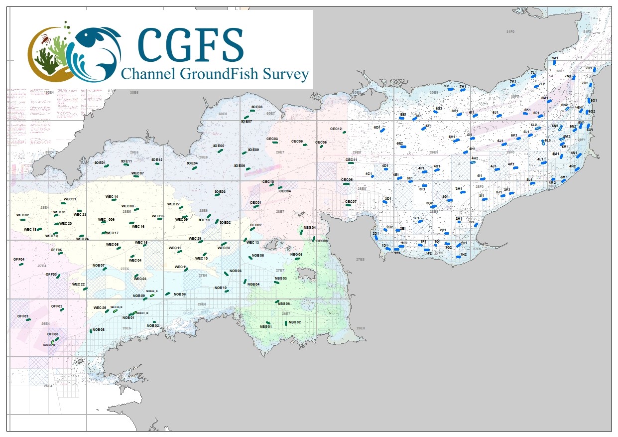
The Channel is an area heavily influenced by fishing, mainly for neighbouring countries but also more widely for northern European countries. The ecological and economic impact of the exploitation of fisheries resources needs to be estimated so that fishing activity remains sustainable while taking into account the limitation of resources and its effect on the environment. To meet this need, EU Member States must carry out at-sea surveys to estimate the abundance and distribution of fish stocks, independently of commercial fishing data. To achieve this objective, the Channel Ground Fish Survey (CGFS) is part of the European Fisheries Monitoring Programme, which collects data on exploited stocks (maturity, age/size structure, recruitment index). The time series started in 1988 and is used annually by the European stock assessment working groups to determine the exploitation status of the main commercial fish species. Initially focused on the eastern Channel, the CGFS now aims to cover the whole Channel to provide fishery-independent data for this area as well. The 2018 CGFS survey will start in Brest in mid-September to collect fishery-independent data to assess the living marine resources of the Channel using a large vertical opening trawl (LOT). For 30 days, 117 30-minute hauls will be made in daylight at a speed of 4 knots. Carried out on the R/V Thalassa, the CGFS will provide the opportunity to sample and better understand the whole ecosystem, which will meet both the requirements of the MSFD and the need for an ecosystem approach to fisheries on a European scale. Thus, the physico-chemical properties of the water, the phytoplankton and zooplankton communities, the abundance of fish eggs, the species composition will be measured and analysed throughout the CGFS study. After the survey, the collected data will be validated and provided to national and European databases (SIH, Harmonie, Coriolis, DATRAS), which will allow the working groups and the general public to have access to these data.
October 1988: Start of the first CGFS campaign on the N/O Gwen Drez. Duration of the hauls 15 minutes, data processing with the "marzine" software, no separation of the sexes on the selachians, no separation of the loligo (squid)
October 1990: Duration of the hauls 30 minutes, processing of selachians by sex
October 1993 : Loligo treatment by species
October 1995: Addition of trawl points in bays to characterise nurseries. Integration of the CGFS programme into the international IBTS group
October 1997: Change of management software (OSACA)
October 2004: Suppression of additional trawling in bays.
October 2008: Monitoring of benthos
October 2014: Inter-calibration with the N/O Thalassa
October 2015: CGFS campaign carried out on the N/O Thalassa - adjustment of stations according to draught - change from 110 to 74 stations in the Eastern Channel
September 2018: Start of the West Channel Series
September / October 2020: No authorisations for work in English waters
Number of observation or measurement points: 122
6 strata in the Western Channel - 48 hauls in the Western Channel and 74 in the Eastern Channel
• Sampling design(s):
Random, stratified
• Precision on the type of data :
- Merlangius merlangus, Pleuronectes platessa, Dicentrarchus labrax, Gadus morhua, Mullus surmuletus, Selachians
- Benthic invertebrates, fish
- Inventory of different types of waste (plastic, glass, metal, plastic bottles, leather and fabrics, fishing gear, miscellaneous)
- Data Pelagic biotope
- Primary production
- Zooplankton
- Ichtyoplankton
- Small pelagic fish
- All fish and invertebrates
- Top predators
- Macro-waste
• Parameter(s) observed or measured :
For fauna :
- Collection of otoliths and scales, sexes, sexual stages, individual weights
- Determination, counting, measuring (fish)
- Resolution of parameter(s) :
- By size class (lower cm)
- Lower Cm, ½ cm lower
For waste :
- Density
Other parameters:
- Temperature, salinity, fluorescence.
- Taxonomy and abundance of phyto and micro zooplankton.
- Abundance and distribution of marine mammals
- Abundance and distribution of marine birds.
- bathymetric acquisitions with multibeam echosounders
- Resolution of parameter(s) :
- For fauna: By fishing operation, continuous survey (CUFES), systematic analysis of scientific fishing catches
- For litter: Density per hectare, By sampling operation on the course
• Format(s):
The available data exist in the format: csv
Process step
- File identifier
- 209fbac0-afce-441c-8844-558796a6b873 XML
- Metadata language
- fr
- Character set
- UTF8
- Parent identifier
- Oceanographic cruises - Observations for fisheries monitoring 99e16a35-8090-4897-aa2b-c5c0951aabea
- Hierarchy level
- Dataset
- Date stamp
- 2022-04-27T09:55:03.017Z
- Metadata standard name
- ISO 19115:2003/19139 - SEXTANT
- Metadata standard version
- 1.0
Overviews
Spatial extent
Provided by
