 Mon GéoSource
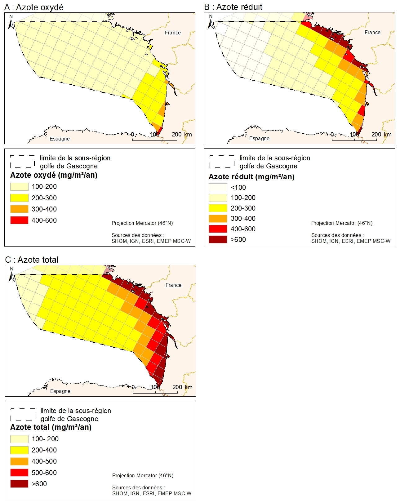
Atmospheric deposition of total nitrogen, oxidized nitrogen and reduced nitrogen in 2008, expressed in mg/m2, following the EMEP model
Data from atmospheric deposition of nitrogen are calculated from emissions data coupled with an atmospheric chemical transport model. Emissions data are from the EMEP program. They are public and available on the EMEP database and are based on emissions data (combustion, waste, transport, agriculture) collected by country. The models estimate atmospheric deposition of oxidized nitrogen, reduced nitrogen and total nitrogen for the period 1995-2008 from the emissions data and meteorological data. Models are driven by EMEP MSC-W (Meteorological Synthesizing Centre West). From the data downloaded from the EMEP, the MPA produced a GIS data format in shp by projecting the data on the EMEP grid projected in North Pole Stereographic
Simple
- Date ( Creation )
- 2008-01-01
- Identifier
- PHY_MET_DCSMM_retombees_atm_azote_EMEP_pol_wgs84
- Credit
- EMEP MSC-E (Meteorological Synthesizing Centre East)
- Thèmes Sextant Thèmes Sextant ( Theme )
-
- /Human Activities/Various
- Keywords ( Theme )
-
- nitrogen; atmospheric deposition; EMEP; MSFD; subregion
- GEMET - INSPIRE themes, version 1.0 GEMET - INSPIRE themes, version 1.0 ( Theme )
-
- atmospheric conditions
- Sous-regions marines Sous-regions marines ( Place )
-
- /Métropole
- Use limitation
- Usage non commercial
- Access constraints
- Other restrictions
- Use constraints
- Other restrictions
- Other constraints
- Utilisation non commerciale autorisée
- Classification
- Unclassified
- Spatial representation type
- Vector
- Metadata language
- fr
- Character set
- UTF8
- Topic category
-
- Environment
- Climatology, meteorology, atmosphere
- Oceans
N
S
E
W
))
- Reference system identifier
- EPSG / WGS 84 (EPSG:4326) / 7.9
- OnLine resource
- DCSMM_RETOMB_ATMO_AZOTE_METRO ( OGC:WMS )
- Protocol
- FILE
- Name
- DCSMM_RETOMB_ATMO_AZOTE_METRO
- Protocol
- OGC:WFS
- Hierarchy level
- Dataset
- Statement
- From the data downloaded from the EMEP, the MPA produced a GIS data format in shp by projecting the data on the EMEP grid projected in North Pole Stereographic
- File identifier
- 3ef4395c-90d1-403c-a79d-3a90200819f0 XML
- Metadata language
- fr
- Character set
- UTF8
- Hierarchy level
- Dataset
- Hierarchy level name
- Jeu de données
- Date stamp
- 2020-06-04T00:59:36
- Metadata standard name
- ISO 19115:2003/19139 - SEXTANT
- Metadata standard version
- 1.0
Overviews
Spatial extent
N
S
E
W
Provided by

Associated resources
Not available