 Mon GéoSource
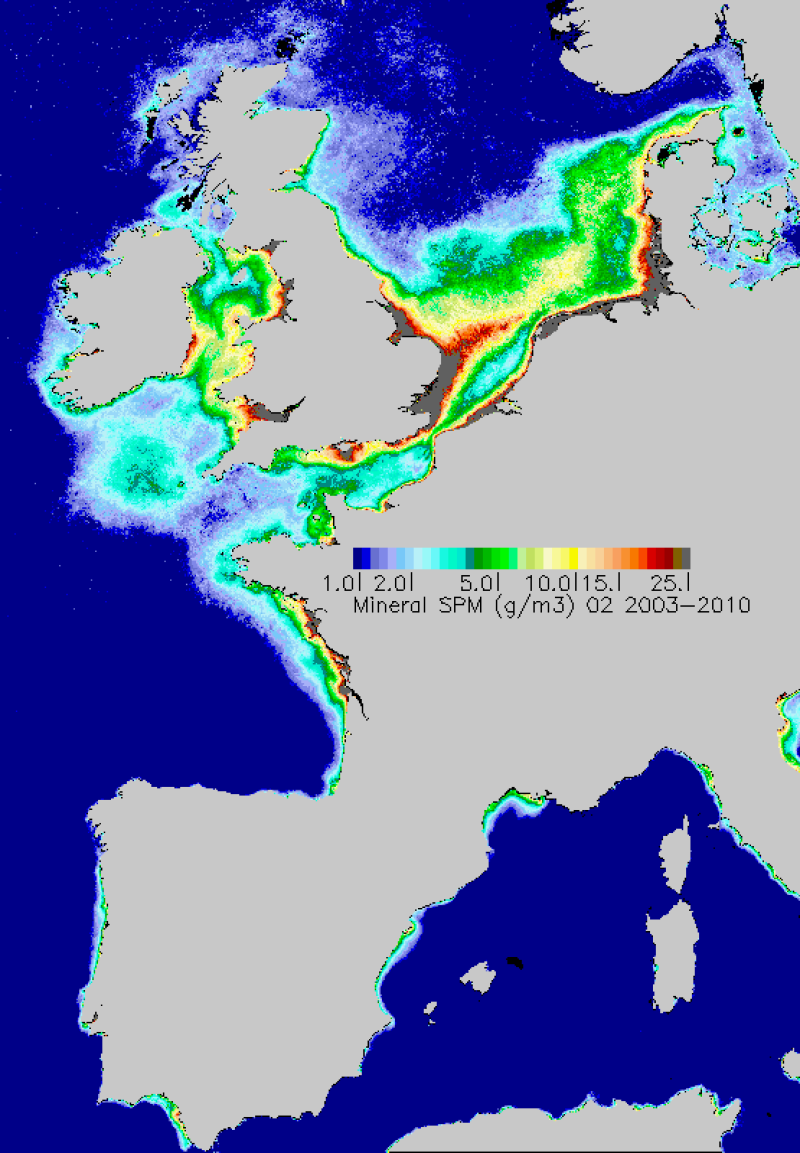
Non-algal Suspended Solids 2003-2010
Simple
- Alternate title
- MES
- Date ( Creation )
- 2011-09-14T17:05:00
- Identifier
- suspended_matters_2003_2010_03
- Identifier
- DOI:10.12770/4a64d155-79fe-441d-8238-76a883effaf7
- Presentation form
- Digital map
- Other citation details
- MODIS/NASA capteur AQUA
- Credit
- NASA, Marcoast, Myocean
- Status
- Completed
02 98 22 45 48
02 98 22 45 48
- Maintenance and update frequency
- As needed
- Thèmes Sextant Thèmes Sextant ( Theme )
-
- /Imagery/Satellite Imagery
- GEMET - INSPIRE themes, version 1.0 GEMET - INSPIRE themes, version 1.0 ( Theme )
-
- Oceanographic geographical features
- external.theme.gemet external.theme.gemet ( Theme )
-
- suspended matter
- Keywords ( Theme )
-
- spm
- Satellite
- Données ouvertes
- Open Data
- DCSMM : Descripteurs DCSMM : Descripteurs ( Theme )
-
- D7: Hydrographical Conditions
- D5: Eutrophication
- GEMET - INSPIRE themes, version 1.0 GEMET - INSPIRE themes, version 1.0 ( Theme )
-
- Oceanographic geographical features
- Sous-regions marines Sous-regions marines ( Place )
-
- Channel-North Sea
- Bay of Biscay
- /Métropole
- Western Mediterranean
- Celtic Seas
- Cadre Réglementaire - SIMM Cadre Réglementaire - SIMM ( Theme )
-
- Directive Cadre pour la Planification de l'Espace Maritime (DCPEM)
- Directive Cadre Stratégie pour le Milieu Marin (DCSMM)
- Type de jeux de donnée ODATIS Type de jeux de donnée ODATIS ( Theme )
-
- /Remote sensing
- Thématiques - SIMM Thématiques - SIMM ( Theme )
-
- /Etat du Milieu/Biogéochimie
- Use limitation
- Conditions inconnues
- Access constraints
- Copyright
- Use constraints
- Copyright
- Spatial representation type
- Grid
- Distance
- 1200 m
- Metadata language
- fr
- Metadata language
- en
- Character set
- UTF8
- Topic category
-
- Oceans
- Environment description
- Microsoft Windows XP ; ESRI ArcGIS 9.x
- Geographic identifier
- Plateau Ouest-Européen
- Begin date
- 2003-01-01T11:32:00
- End date
- 2010-12-31T09:00:00
))
- Supplemental Information
- Gohin, F., Loyer, S., Lunven, M., Labry, C., Froidefond, J. M., Delmas, D., Huret, M., and Herbland, A.: Satellite-derived parameters for biological modelling in coastal waters: Illustration over the eastern continental shelf of the bay of biscay, Remote Sensing of Environment, 95, 29-46, 10.1016/j.rse.2004.11.007, 2005.
- Reference system identifier
- WGS 84 (EPSG:4326)
- Number of dimensions
- 2
- Dimension name
- Column
- Dimension size
- 1667
- Resolution
- 0.015 degree
- Dimension name
- Row
- Dimension size
- 2401
- Resolution
- 0.01 degree
- Cell geometry
- Area
- Transformation parameter availability
- No
Distributor
- OnLine resource
-
suspended_matters_2003_2010_01
(
OGC:WMS
)
January
- Protocol
- COPYFILE
- Name
- suspended_matters_2003_2010_01
- Description
- January
- OnLine resource
-
suspended_matters_2003_2010_02
(
OGC:WMS
)
Février
- Protocol
- COPYFILE
- Name
- suspended_matters_2003_2010_02
- Description
- Février
- OnLine resource
-
suspended_matters_2003_2010_03
(
OGC:WMS
)
Mars
- Protocol
- COPYFILE
- Name
- suspended_matters_2003_2010_03
- Description
- Mars
- OnLine resource
-
suspended_matters_2003_2010_04
(
OGC:WMS
)
Avril
- Protocol
- COPYFILE
- Name
- suspended_matters_2003_2010_04
- Description
- Avril
- OnLine resource
-
suspended_matters_2003_2010_05
(
OGC:WMS
)
Mai
- Protocol
- COPYFILE
- Name
- suspended_matters_2003_2010_05
- Description
- Mai
- OnLine resource
-
suspended_matters_2003_2010_06
(
OGC:WMS
)
Juin
- Protocol
- COPYFILE
- Name
- suspended_matters_2003_2010_06
- Description
- Juin
- OnLine resource
-
suspended_matters_2003_2010_07
(
OGC:WMS
)
Juillet
- Protocol
- COPYFILE
- Name
- suspended_matters_2003_2010_07
- Description
- Juillet
- OnLine resource
-
suspended_matters_2003_2010_08
(
OGC:WMS
)
Aout
- Protocol
- COPYFILE
- Name
- suspended_matters_2003_2010_08
- Description
- Aout
- OnLine resource
-
suspended_matters_2003_2010_09
(
OGC:WMS
)
Septembre
- Protocol
- COPYFILE
- Name
- suspended_matters_2003_2010_09
- Description
- Septembre
- OnLine resource
-
suspended_matters_2003_2010_10
(
OGC:WMS
)
Octobre
- Protocol
- COPYFILE
- Name
- suspended_matters_2003_2010_10
- Description
- Octobre
- OnLine resource
-
suspended_matters_2003_2010_11
(
OGC:WMS
)
Novembre
- Protocol
- COPYFILE
- Name
- suspended_matters_2003_2010_11
- Description
- Novembre
- OnLine resource
-
suspended_matters_2003_2010_12
(
OGC:WMS
)
Décembre
- Protocol
- COPYFILE
- Name
- suspended_matters_2003_2010_12
- Description
- Décembre
- Hierarchy level
- Dataset
Conformance result
- Date ( Publication )
- 2007-03-14
- Explanation
- not evaluated
- Pass
- No
- Statement
- SPM derived from the spectral reflectance of MODIS/AQUA averaged monthly from January 2003 to December 2010. MODIS data reprocessing NASA 2011
- Description
- SPM estimated by the Ifremer algorithm applied to MODIS. Method developed in Ifremer report:wwz.ifremer.fr/dcsmm/.../DCSMM_rapport-tsm-chl-turb_ifremer-janv2011-V1.pdf
- File identifier
- 4a64d155-79fe-441d-8238-76a883effaf7 XML
- Metadata language
- fr
- Character set
- UTF8
- Hierarchy level
- Dataset
- Date stamp
- 2020-06-04T00:30:32
- Metadata standard name
- ISO 19115:2003/19139 - SEXTANT
- Metadata standard version
- 1.0
02 98 22 45 48
Overviews
Spatial extent
Provided by
