 Mon GéoSource
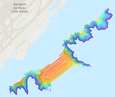
Bathymétrie - mer Ligure, aéroport de Nice (campagne MAROLIS PENFELD, 2020) résolution 2 m
Bathymétrie du plateau au large de l'aéroport de Nice, en Mer Ligure (campagne MAROLIS PENFELD, 2020), au pas de 2 mètres (projection Mercator 43,6°N). Acquisition par le sondeur Reson Seabat 7111 du Pourquoi pas ?.
Référence verticale : niveau moyen des mers.
Traitements réalisés : Gaillot Arnaud (2021). Mission MaRoLiS PENFELD: Traitement des données SMF coque. PDG/REM/GM/CTDI/20210108_AG01_MAROLIS_TraitementSMF. https://archimer.ifremer.fr/doc/00676/78783/
Description de la campagne : GARZIGLIA Sébastien (2020) MaRoLiS PENFELD cruise, RV Pourquoi pas ?, https://doi.org/10.17600/18000671
Simple
- Date ( Creation )
- 2021-05-07
- Identifier
- DOI:10.12770/653e304c-8141-4d68-bcee-5fb9f9ce2059
- Presentation form
- Digital model
- Credit
- Ifremer
08 98 22 45 89
- Maintenance and update frequency
- As needed
- Keywords ( Discipline )
-
- Bathymétrie
- GEMET - INSPIRE themes, version 1.0 ( Theme )
-
- Altitude
- GEMET - Concepts, version 3.1 ( Theme )
-
- Fond marin
- Morphologie sous-marine
- Thèmes Sextant ( Theme )
-
- /Milieu physique/Bathymétrie/MNT
- Keywords ( Place )
-
- Mer Ligure
- Nice
- Use limitation
- Ne pas utiliser pour la navigation
- Access constraints
- Other restrictions
- Use constraints
- License
- Other constraints
- Accès libre
- Spatial representation type
- Grid
- Distance
- 2 m
- Denominator
- 4000
- Metadata language
- Françaisfr
- Character set
- UTF8
- Topic category
-
- Elevation
- Environment description
- Version 6.2 (Build 9200) ; Esri ArcGIS 10.8.1.14362
))
- Reference system identifier
- EPSG / WGS84 / WORLD MERCATOR (EPSG 3395) latitude 43,6°N / 8.2.6
- Number of dimensions
- 2
- Dimension name
- Column
- Dimension size
- 1421
- Resolution
- 2 m
- Dimension name
- Row
- Dimension size
- 1119
- Resolution
- 2 m
- Cell geometry
- Area
- Transformation parameter availability
- Yes
- Checkpoint Availability
- No
Center point
- Point in Pixel
-
- Center
- Distribution format
-
-
Jeu de données Raster
()
-
Jeu de données Raster
()
- OnLine resource
- DOI du jeu de données ( WWW:LINK )
- OnLine resource
- Campagne MaRoLiS PENFELD ( WWW:LINK )
- OnLine resource
- MAROLIS_Aeroport_2m_BATHY ( OGC:WMS )
- Protocol
- COPYFILE
- Name
- MAROLIS_Aeroport_2m_BATHY
- Hierarchy level
- Dataset
- Statement
-
Les données ont été traitées à l’aide du logiciel GLOBE (version 1.16.9).
Aucune correction de marée. La référence verticale du jeu de données est le niveau moyen des mers.
Rapport de traitement : https://archimer.ifremer.fr/doc/00676/78783/
- Content type
- Image
- Descriptor
- Band_1
- Maximum value
- -11.1
- Minimum value
- -99.980003
- Bits per value
- 32
- File identifier
- 653e304c-8141-4d68-bcee-5fb9f9ce2059 XML
- Metadata language
- Françaisfr
- Character set
- UTF8
- Hierarchy level
- Dataset
- Hierarchy level name
- dataset
- Date stamp
- 2022-03-17T10:27:17.566Z
- Metadata standard name
- ISO 19115:2003/19139 - SEXTANT
- Metadata standard version
- V. 1.2
Overviews
Spatial extent
Provided by
