 Mon GéoSource
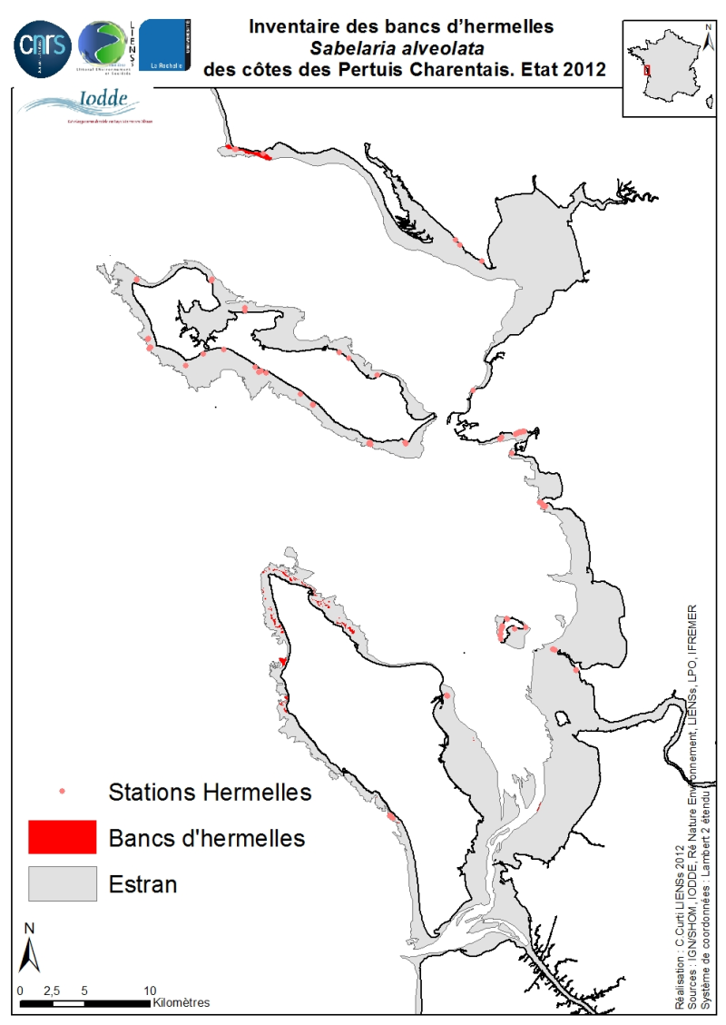
Inventory Hermelles Sabelaria alveolata beds on the coasts of Pertuis Charentais. Environmental state for 2012
The geographical distribution of the main Sabellaria Hermelles alveolata beds (Linné, 1767) from the coast of the Pertuis Charentais was compiled from 2010 to 2012. The inventory focuses on the tidal beds (+ 6-0 m marine coast) and compiles two cartographic sources from the project CARTHAM Natura 2000 at sea of the Agency of Marine Protected Areas:
1) Hermelles inventories made on 2011 by the Association IODDE on the west of Oleron Island and
2) mapping inventory of intertidal marine habitats by LIENSs (in cooperation with CREOCEAN, Ré Nature Environnement, GEO-Transfert et la LPO Moëze-Oléron).
Methodologies used by IODDE on Oléron combine ground truths with reports with Geographic Information System (GIS). The methodologies used by LIENSs to estimate the extension of the intertidal habitats throughout the Pertuis Charentais combine aerial image analysis, remote sensing, field validations by differential GPS and thematic analysis using GIS (Cajeri et al., 2012). It is during these ground truths that the presence of tackles or small Hermelles reefs was noted.
The IODDE results have allowed an almost exhaustive inventory of Hermelles reefs west of Oleron. Those of LIENSs have clarified the distribution of Hermelles on most of the Pertuis Charentais foreshores.
Simple
- Date ( Creation )
- 2012-09-30T16:00:00
- Identifier
- FR-330-715-368-00198-ifr-ANN-SABEALV-PERTUIS
- Purpose
- This shape file was created in order to make a specific cartographic inventory of the main Hermelles Sabellaria alveolata beds in Pertuis Charentais.
- Credit
- IODDE : A. Privat, digitalisation et validation biologique. LIENSs-CNRS-Université de la Rochelle : C. Curti, digitalisation, P. Cajeri, F. Aubert et P.-G. Sauriau, validation biologique.
- Status
- On going
- Maintenance and update frequency
- As needed
- Thèmes Sextant Thèmes Sextant ( Theme )
-
- /Biological Environment/Key Habitats/Honeycomb Worm
- Keywords ( Discipline )
-
- Biology, benthos, marine culture, Sabellaria alveolata
- Keywords ( Place )
-
- Pertuis Charentais Sea
- Keywords ( Stratum )
-
- 0 à +6 m CM
- Keywords ( Temporal )
-
- 2010-2012
- Keywords ( Theme )
-
- Biology, fauna, species distribution
- GEMET - INSPIRE themes, version 1.0 GEMET - INSPIRE themes, version 1.0 ( Theme )
-
- Species distribution
- Type de jeux de donnée ODATIS Type de jeux de donnée ODATIS ( Theme )
-
- /Processed data/Composite products
- Thématiques - SIMM Thématiques - SIMM ( Theme )
-
- /Etat du Milieu/Habitats
- Sous-regions marines Sous-regions marines ( Place )
-
- Bay of Biscay
- Use limitation
- Ce fichier est destiné à un usage personnel et non commercial. Pour tout usage autre que personnel, veuillez prendre contact avec le distributeur. Toute modification de cette donnée est soumise à une autorisation préalable. Pour cela, veuillez prendre contact avec le gestionnaire de la donnée
- Access constraints
- Other restrictions
- Access constraints
- Copyright
- Use constraints
- Copyright
- Other constraints
- Obligation de citation sur la carte : « Sources : LIENSs, IODDE. Réalisation : C. Curti, 2012 ; produit numérique LIENSs / CNRS / Université de la Rochelle / IODDE »
- Other constraints
- Obligation de citation dans la bibliographie : Cajeri P., Curti C., Lafon V., Launay R. & Sauriau P.-G. (2012). Cartographie des habitats intertidaux des sites Natura 2000 des Pertuis charentais : complémentarité des approches inventaire terrain, télédétection et SIG. In: Actes des XIIèmes Journées Nationales Génie Côtier – Génie Civil. D. Levachez, Sanchez M. & Guillou S., (eds), Cherbourg : pp. 855-864.
- Spatial representation type
- Vector
- Denominator
- 200000
- Metadata language
- fr
- Character set
- UTF8
- Topic category
-
- Biota
- Environment description
- Relevés DGPS puis digitalisation à partir des ortho 2000 sous ArcGis 10
- Begin date
- 2009-01-01T14:00:00
- End date
- 2012-09-30T14:00:00
))
- Reference system identifier
- EPSG / WGS 84 (EPSG:4326) / 7.4
- Topology level
- Geometry only
- Geometric object type
- Surface
- Geometric object count
- 106
- Geometric object type
- Point
- Geometric object count
- 88
- Distribution format
-
-
shp
(
10
)
-
shp
(
10
)
- OnLine resource
- sextant@ifremer.fr ( WWW:LINK )
- Hierarchy level
- Attribute
Conformance result
- Date ( Creation )
- 2012-01-16
- Explanation
- not evaluated
- Pass
- No
- Statement
- This map was produced from mapping done by LIENSs and IODDE through GIS in the project CARTHAM.
- File identifier
- 731f30bc-ce55-4086-af67-76cf698b804c XML
- Metadata language
- fr
- Character set
- UTF8
- Hierarchy level
- Dataset
- Date stamp
- 2020-06-04T01:09:15
- Metadata standard name
- ISO 19115:2003/19139 - SEXTANT
- Metadata standard version
- 1.0
Overviews
Spatial extent
Provided by
