 Mon GéoSource
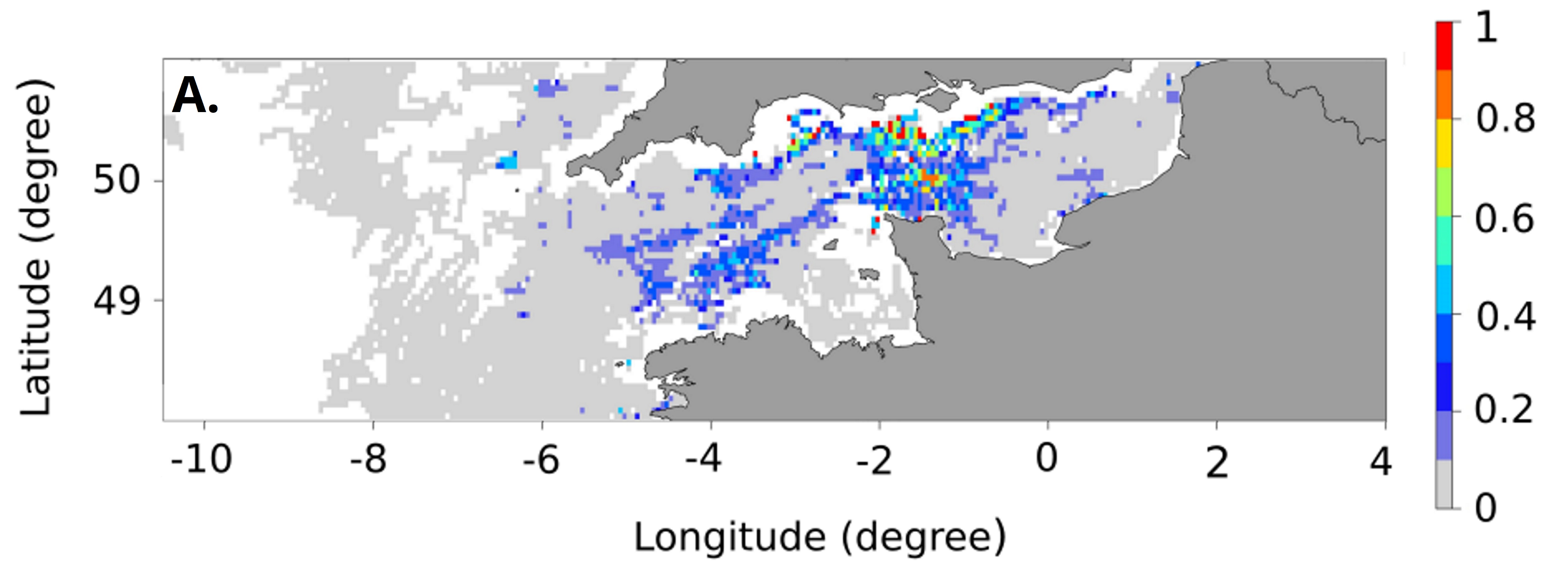
Spawning areas of Dicentrarchus labrax in the English Channel - Celtic Sea
Simple
- Date ( Publication )
- 2020-12-20
- Identifier
- DOI:10.12770/763b125d-afbe-4d32-bd0f-707c1f4474a8
- Credit
- IFREMER - STH - LBH
- Thèmes Sextant Thèmes Sextant ( Theme )
-
- /Biological Environment/Species/Fish Species of Commercial Interest
- GEMET - INSPIRE themes, version 1.0 GEMET - INSPIRE themes, version 1.0 ( Theme )
-
- Habitats and biotopes
- Keywords
-
- seabass
- sea bass
- essential fish habitat
- zone fonctionnelle
- Use limitation
- CC-BY-NC-ND (Creative Commons - Attribution, Pas d’utilisation commerciale, Pas de modification)
- Access constraints
- License
- Use constraints
- License
- Spatial representation type
- Vector
- Denominator
- 5000
- Metadata language
- en
- Character set
- UTF8
- Topic category
-
- Oceans
))
- Unique resource identifier
- EPSG:4326
- Geometric object type
- Surface
- Distribution format
-
-
(
)
-
(
)
- OnLine resource
-
Main publication
(
WWW:LINK-1.0-http--publication-URL
)
Dambrine, C., Woillez, M., Huret, M. and de Pontual, H. (2021), Characterising Essential Fish Habitat using spatio-temporal analysis of fishery data: A case study of the European seabass spawning areas. Fish Oceanogr, 30: 413-428. https://doi.org/10.1111/fog.12527
- OnLine resource
-
DOI of the dataset
(
WWW:LINK-1.0-http--metadata-URL
)
DOI of the dataset
- OnLine resource
-
IFR_STH_FRAYERES_BAR_MANCHE_MER_CELTIQUE_JANVIER
(
OGC:WMS
)
Frayères du bar - Janvier
- OnLine resource
-
IFR_STH_FRAYERES_BAR_MANCHE_MER_CELTIQUE_JANVIER
(
OGC:WFS
)
Frayères du bar - Janvier
- OnLine resource
-
IFR_STH_FRAYERES_BAR_MANCHE_MER_CELTIQUE_FEVRIER
(
OGC:WMS
)
Frayères du bar - Février
- OnLine resource
-
IFR_STH_FRAYERES_BAR_MANCHE_MER_CELTIQUE_FEVRIER
(
OGC:WFS
)
Frayères du bar - Février
- OnLine resource
-
IFR_STH_FRAYERES_BAR_MANCHE_MER_CELTIQUE_MARS
(
OGC:WMS
)
Frayères du bar - Mars
- OnLine resource
-
IFR_STH_FRAYERES_BAR_MANCHE_MER_CELTIQUE_MARS
(
OGC:WFS
)
Frayères du bar - Mars
- OnLine resource
-
IFR_STH_FRAYERES_BAR_MANCHE_MER_CELTIQUE_AVRIL
(
OGC:WMS
)
Frayères du bar - Avril
- OnLine resource
-
IFR_STH_FRAYERES_BAR_MANCHE_MER_CELTIQUE_AVRIL
(
OGC:WFS
)
Frayères du bar - Avril
- OnLine resource
-
IFR_STH_FRAYERES_BAR_MANCHE_MER_CELTIQUE_MOYENNE
(
OGC:WMS
)
Frayères du bar - Moyenne
- OnLine resource
-
IFR_STH_FRAYERES_BAR_MANCHE_MER_CELTIQUE_MOYENNE
(
OGC:WFS
)
Frayères du bar - Moyenne
- Hierarchy level
- Dataset
Conformance result
- Date ( Publication )
- 2010-12-08
- Explanation
- See the referenced specification
- Statement
-
These data were produced during a thesis carried out within the framework of the Barfray project financed by the European Fund for Fisheries and the Sea (FEAMP-OSIRIS N °: PFEA 400017DM0720006), France Filière Pêche (FFP), the French Ministry of Agriculture and Food (MAF) and Ifremer.
The idea was to improve the knowledge available on the spawning areas of European seabass (Dicentrarchus labrax) in the northeast Atlantic. To do so, we characterized the seabass spawning areas along the French Atlantic coast (English Channel and Bay of Biscay) using fishing data from geolocated vessels (VMS data provided by the Direction des Pêches Maritimes et de l'Aquaculture (DPMA) and the Système d'Informations Halieutiques (SIH) of Ifremer). A non-linear geostatistical approach was carried out over the years 2008-2013 to detect areas where seabass aggregate to reproduce. Spawning areas occurrence maps were produced for each month of the spawning season. These occurrence maps were summarised in average maps representing the probability of being a spawning area. These maps allow quantifying the seasonal and interannual variability, and highlight the recurrent, occasional and unfavourable spawning areas. An average map over all months of the spawning season was also produced to summarise the results and simplify the use.
- File identifier
- 763b125d-afbe-4d32-bd0f-707c1f4474a8 XML
- Metadata language
- en
- Character set
- UTF8
- Parent identifier
- 55b44ab3-0b69-4bc4-8d4d-0ad2e022005c 55b44ab3-0b69-4bc4-8d4d-0ad2e022005c
- Hierarchy level
- Dataset
- Date stamp
- 2022-03-16T15:20:21.921Z
- Metadata standard name
- ISO 19115:2003/19139 - SEXTANT
- Metadata standard version
- 1.0
Overviews
Spatial extent
Provided by
