 Mon GéoSource
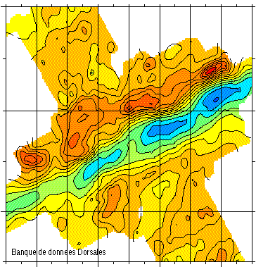
Free Air Gravity Anomaly grid - Mohns Ridge 71.75°-73°N - 900m
Simple
- Date ( Creation )
- 1993-12-23
- Identifier
- IFR_MBAN_DORSALES_MOHN_GRAVI_FAA_900_R
- Identifier
- DOI:10.12770/7cbb6c48-2fe0-40ed-ad23-0293a19d5b83
- Credit
- The project is part of the national program Dorsales and represents the French contribution to the InterRidge Data Banks project (see InterRidge News 1997, vol. 6/1 and 1999, vol. 8/1).
+33 (0)2 98.22.46.44
http://www.ifremer.fr/sismer/
- Thèmes Sextant Thèmes Sextant ( Theme )
-
- /Physical Environment/Sedimentology Geology/Geomorphology
- GEMET - INSPIRE themes, version 1.0 GEMET - INSPIRE themes, version 1.0 ( Theme )
-
- Oceanographic geographical features
- Thématiques - SIMM Thématiques - SIMM ( Theme )
-
- /Etat du Milieu/Géologie
- /Etat du Milieu/Bathymétrie
- Type de jeux de donnée ODATIS Type de jeux de donnée ODATIS ( Theme )
-
- /Processed data/Model outputs
- Thématiques - SIMM Thématiques - SIMM ( Theme )
-
- Recherche
- Use limitation
- CC-BY (Creative Commons - Attribution)
- Access constraints
- Other restrictions
- Use constraints
- License
- Other constraints
-
The project is part of the national program Dorsales and represents the French contribution to the InterRidge Data Banks project (see InterRidge News 1997, vol. 6/1 and 1999, vol. 8/1).
Géli L., Renard V., Rommevaux C., 1994 - Ocean crust formation processes at the Mohns Ridge, near 72°N: a model, for a very slow spreading ridge, based on magnetic, gravity and tomographic data - J. Geophys. Res., 99, 2995-3013.
- Spatial representation type
- Grid
- Denominator
- 25000
- Metadata language
- fr
- Character set
- UTF8
- Topic category
-
- Oceans
))
- Reference system identifier
- EPSG / WGS 84 (EPSG:4326) / 8.6
- Number of dimensions
- 2
- Dimension name
- Column
- Resolution
- 1 minutes
- Dimension name
- Row
- Resolution
- 0.5 minutes
- Cell geometry
- Area
- Distribution format
-
-
(
)
-
(
)
- OnLine resource
-
MOHNS_BATHY
(
OGC:WMS
)
Bathymetry (WMS)
- Protocol
- FILE
- Name
- MOHNS_BATHY
- Description
- Bathymétrie - format .tif and .grd
- OnLine resource
-
DOI du jeu de données
(
WWW:LINK-1.0-http--metadata-URL
)
DOI du jeu de données
- Protocol
- COPYFILE
- Name
- IFR_MBAN_DORSALES_MOHN_GRAVI_FAA_900_R_GRD
- Description
- Gravimétrie 900m - format .grd
- OnLine resource
- DOI de la campagne - MOHNS RIDGE 1 ( WWW:LINK )
- Hierarchy level
- Dataset
- Statement
- Sources : Données de la campagne J. Charcot 1988, données Seabeam
- Description
- 0 spline en tension (surface)
- Rationale
- Interpolation
- Description
- Masquage à partir des données bathymétriques avec l’opérateur grdmask (rayon 5 km)
- Rationale
- Masquage
Content Information
- File identifier
- 7cbb6c48-2fe0-40ed-ad23-0293a19d5b83 XML
- Metadata language
- fr
- Character set
- UTF8
- Hierarchy level
- Dataset
- Date stamp
- 2020-08-31T11:19:00
- Metadata standard name
- ISO 19115:2003/19139 - SEXTANT
- Metadata standard version
- 1.0
Overviews
Spatial extent
Provided by
