 Mon GéoSource
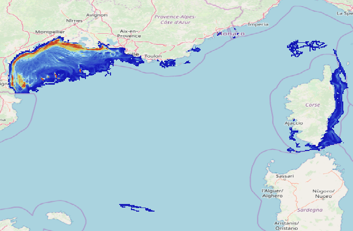
Surface abrasion of seabeds by bottom contacting fishing gears - Mediterranean Sea (surface Swept Area Ratio)
Simple
- Date ( Creation )
- 2020-06-01
- Identifier
- FR-330-715-368-00032-IFR_MARBEC_Surf_SAR_MED_FR
- Identifier
- DOI:10.12770/8bed2328-a0fa-4386-8a3e-d6d146cafe54
- Credit
- This work was supported by the IDEM (EU), Benthchal (EC2CO) projects and the Occitanie region
- Thèmes Sextant Thèmes Sextant ( Theme )
-
- /Human Activities/Recreational Fishing
- GEMET - INSPIRE themes, version 1.0 GEMET - INSPIRE themes, version 1.0 ( Theme )
-
- Habitats and biotopes
- Sous-regions marines Sous-regions marines ( Place )
-
- Western Mediterranean
- Cadre Réglementaire - SIMM Cadre Réglementaire - SIMM ( Theme )
-
- Directive Cadre Stratégie pour le Milieu Marin (DCSMM)
- Thématiques - SIMM Thématiques - SIMM ( Theme )
-
- /Activités et Usages/Pêche et Aquaculture
- /Etat du Milieu/Habitats
- Type de jeux de donnée ODATIS Type de jeux de donnée ODATIS ( Theme )
-
- /Processed data/Composite products
- DCSMM : Descripteurs DCSMM : Descripteurs ( Theme )
-
- D6: Sea-floor Integrity
- D1: Coastal benthic habitats
- D1: Biodiversité - Poissons
- D1: Fish and Cephalopods
- Ocean Hackathon - Ville Ocean Hackathon - Ville ( Place )
-
- Toulon
- Use limitation
- Données sous Licence Creative Commons - Attribution + Pas d’Utilisation Commerciale + Partage dans les mêmes conditions (BY-NC-SA) : http://creativecommons.fr/licences/
- Access constraints
- Other restrictions
- Use constraints
- Copyright
- Spatial representation type
- Grid
- Distance
- 0.0166667 degree
- Metadata language
- fr
- Character set
- UTF8
- Topic category
-
- Imagery base maps earth cover
))
- Begin date
- 2008-01-01
- End date
- 2017-12-31
- Reference system identifier
- EPSG / WGS 84 (EPSG:4326) / 8.6
- Distribution format
-
-
(
)
-
(
)
- OnLine resource
-
Publication 1
(
WWW:LINK
)
Eigaard Ole R., Bastardie Francois, Breen Mike, Dinesen Grete E., Hintzen Niels T., Laffargue Pascal, Mortensen Lars O., Nielsen J. Rasmus, Nilsson Hans C., O'Neill Finbarr G., Polet Hans, Reid David G., Sala Antonello, Skold Mattias, Smith Chris, Sorensen Thomas K., Tully Oliver, Zengin Mustafa, Rijnsdorp Adriaan D. (2016). Estimating seabed pressure from demersal trawls, seines, and dredges based on gear design and dimensions . Ices Journal Of Marine Science , 73, 27-43. https://doi.org/10.1093/icesjms/fsv099
- OnLine resource
-
The footprint of bottom trawling in European waters: distribution, intensity, and seabed integrity
(
WWW:LINK
)
Ole R. Eigaard, Francois Bastardie, Niels T. Hintzen, Lene Buhl-Mortensen, Pål Buhl-Mortensen, Rui Catarino, Grete E. Dinesen, Josefine Egekvist, Heino O. Fock, Kerstin Geitner, Hans D. Gerritsen, Manuel Marín González, Patrik Jonsson, Stefanos Kavadas, Pascal Laffargue, Mathieu Lundy, Genoveva Gonzalez-Mirelis, J. Rasmus Nielsen, Nadia Papadopoulou, Paulette E. Posen, Jacopo Pulcinella, Tommaso Russo, Antonello Sala, Cristina Silva, Christopher J. Smith, Bart Vanelslander, Adriaan D. Rijnsdorp, Handling editor: Michel Kaiser; The footprint of bottom trawling in European waters: distribution, intensity, and seabed integrity, ICES Journal of Marine Science, Volume 74, Issue 3, 1 March 2017, Pages 847–865, https://doi.org/10.1093/icesjms/fsw194
- OnLine resource
-
Surf_SAR_MED_FR_P90_08_2020
(
OGC:WMS
)
Swept Area Ratio - Méditerranée - 2008 à 2020
- Protocol
- COPYFILE
- Name
- Surf_SAR_MED_FR_P90_08_2020
- Description
- Swept Area Ratio - Méditerranée - 2008 à 2020
- OnLine resource
-
Surf_SAR_MED_FR_2008
(
OGC:WMS
)
Swept Area Ratio - Méditerranée - 2008
- Protocol
- COPYFILE
- Name
- Surf_SAR_MED_FR_2008
- Description
- Swept Area Ratio - Méditerranée - 2008
- OnLine resource
-
Surf_SAR_MED_FR_2009
(
OGC:WMS
)
Swept Area Ratio - Méditerranée - 2009
- Protocol
- COPYFILE
- Name
- Surf_SAR_MED_FR_2009
- Description
- Swept Area Ratio - Méditerranée - 2009
- OnLine resource
-
Surf_SAR_MED_FR_2010
(
OGC:WMS
)
Swept Area Ratio - Méditerranée - 2010
- Protocol
- COPYFILE
- Name
- Surf_SAR_MED_FR_2010
- Description
- Swept Area Ratio - Méditerranée - 2010
- OnLine resource
-
Surf_SAR_MED_FR_2011
(
OGC:WMS
)
Swept Area Ratio - Méditerranée - 2011
- Protocol
- COPYFILE
- Name
- Surf_SAR_MED_FR_2011
- Description
- Swept Area Ratio - Méditerranée - 2011
- OnLine resource
-
Surf_SAR_MED_FR_2012
(
OGC:WMS
)
Swept Area Ratio - Méditerranée - 2012
- Protocol
- COPYFILE
- Name
- Surf_SAR_MED_FR_2012
- Description
- Swept Area Ratio - Méditerranée - 2012
- OnLine resource
-
Surf_SAR_MED_FR_2013
(
OGC:WMS
)
Swept Area Ratio - Méditerranée - 2013
- Protocol
- COPYFILE
- Name
- Surf_SAR_MED_FR_2013
- Description
- Swept Area Ratio - Méditerranée - 2013
- OnLine resource
-
Surf_SAR_MED_FR_2014
(
OGC:WMS
)
Swept Area Ratio - Méditerranée - 2014
- Protocol
- COPYFILE
- Name
- Surf_SAR_MED_FR_2014
- Description
- Swept Area Ratio - Méditerranée - 2014
- OnLine resource
-
Surf_SAR_MED_FR_2015
(
OGC:WMS
)
Swept Area Ratio - Méditerranée - 2015
- Protocol
- COPYFILE
- Name
- Surf_SAR_MED_FR_2015
- Description
- Swept Area Ratio - Méditerranée - 2015
- OnLine resource
-
Surf_SAR_MED_FR_2016
(
OGC:WMS
)
Swept Area Ratio - Méditerranée - 2016
- Protocol
- COPYFILE
- Name
- Surf_SAR_MED_FR_2016
- Description
- Swept Area Ratio - Méditerranée - 2016
- OnLine resource
-
Surf_SAR_MED_FR_2017
(
OGC:WMS
)
Swept Area Ratio - Méditerranée - 2017
- Protocol
- COPYFILE
- Name
- Surf_SAR_MED_FR_2017
- Description
- Swept Area Ratio - Méditerranée - 2017
- Protocol
- COPYFILE
- Name
- Surf_SAR_MED_FR_2018
- Description
- Swept Area Ratio - Méditerranée - 2018
- Protocol
- COPYFILE
- Name
- Surf_SAR_MED_FR_2019
- Description
- Swept Area Ratio - Méditerranée - 2019
- Protocol
- COPYFILE
- Name
- Surf_SAR_MED_FR_2020
- Description
- Swept Area Ratio - Méditerranée - 2020
- OnLine resource
-
DOI du jeu de donnée
(
WWW:LINK-1.0-http--metadata-URL
)
DOI du jeu de donnée
- OnLine resource
-
Surf_SAR_MED_FR_2018
(
OGC:WMS
)
Swept Area Ratio - Méditerranée - 2018
- OnLine resource
-
Surf_SAR_MED_FR_2019
(
OGC:WMS
)
Swept Area Ratio - Méditerranée - 2019
- OnLine resource
-
Surf_SAR_MED_FR_2020
(
OGC:WMS
)
Surf_SAR_MED_FR_2020
- Hierarchy level
- Dataset
Conformance result
- Date ( Publication )
- 2010-12-08
- Explanation
- See the referenced specification
- Statement
- This work attempts to approximate the approach used by Eigaard et al (2016-2017) based on aggregated VMS data on a 1'x1' grid.
- Description
- The raw data used were produced by Ifremer’s SIH (Système d’Information Halieutique) AlgoPesca procedure in order to keep only positions corresponding to fishing operations (non-null speed <= 4 kts, away from return harbour routes). Data was expressed in number of fishing hours and aggregated in 1’x1’ grid by flag, month, size class of vessel and gear type (corresponding to landing declarations or main fishing gear recorded in the Community Fishing Fleet Register.
- Description
-
Abrasion depending on both vessel speed and type of gear used, different values of speed or horizontal trawl opening were attributed according to vessel’s length and flag thanks to bibliography, law regulations and experts’ knowledge (local trawl manufacturers, trawl owners and captains and fishery organization representatives). In the case of dredges (French ; ≤ 15m) speed was set at 3kt and opening to 4m before 2013 (included) and 3m after (JORF 2013; https://www.legifrance.gouv.fr/eli/arrete/2013/4/12/TRAM1309072A/jo/texte/fr ). Speed of Italian vessels was also set at 3 kts and the horizontal trawl opening was estimated following Eigaard et al. (2016). Thus, Italian trawling had a horizontal trawl opening range between 77 m and 50 m depending on vessels’ length :
- ≥ 24 m : 77 m
- ]18-24] : 72 m
- ]15-18] : 58 m
- ]12-15] : 50 m
For all French and Spanish vessels < 24m, speed was set at 3.5 kt and at 4 kt for vessels equal or larger than 24m.
Horizontal trawl opening for Spanish vessels was fixed to 100m regardless their length. French twin-rig otter trawls used on vessel large or equal to 24 m were set vith a horizontal trawl opening of 110 m and vessels between 18 and 24m had a 95m opening. Other French bottom otter trawls opening range between 100 and 55 m depending on the vessel length :
- ≥ 24 m : 100 m
- ]18-24] : 75 m
- ]15-18] : 55 m
- ≤ 15 m : 55 m
Distance traveled by each vessel category inside a 1'x1' cell was determined by multiplying the speed of the ship by the number of hour spent in the cell. The area swept by each vessel was calculated for each cell by multiplying the distance traveled by the horizontal trawl opening (or dredge width). Ratio between cell‘s swept area and cell surface allows to obtain the abrasion caused by each flag/vessel length/gear type in each cell per month (Eigaard et al. 2016, 2017). These abrasions are summed by cell over each year to get an annual abrasion value for each cell. Inter-annual 90th percentile was calculated for each cell allowing to get a spatial representation of the maximum abrasion values experienced in the study area over a 10-year period, while avoiding extreme values or outliers.
- File identifier
- 8bed2328-a0fa-4386-8a3e-d6d146cafe54 XML
- Metadata language
- fr
- Character set
- UTF8
- Hierarchy level
- Dataset
- Date stamp
- 2021-06-14T12:05:09
- Metadata standard name
- ISO 19115:2003/19139 - SEXTANT
- Metadata standard version
- 1.0
Overviews
Spatial extent
Provided by
