 Mon GéoSource
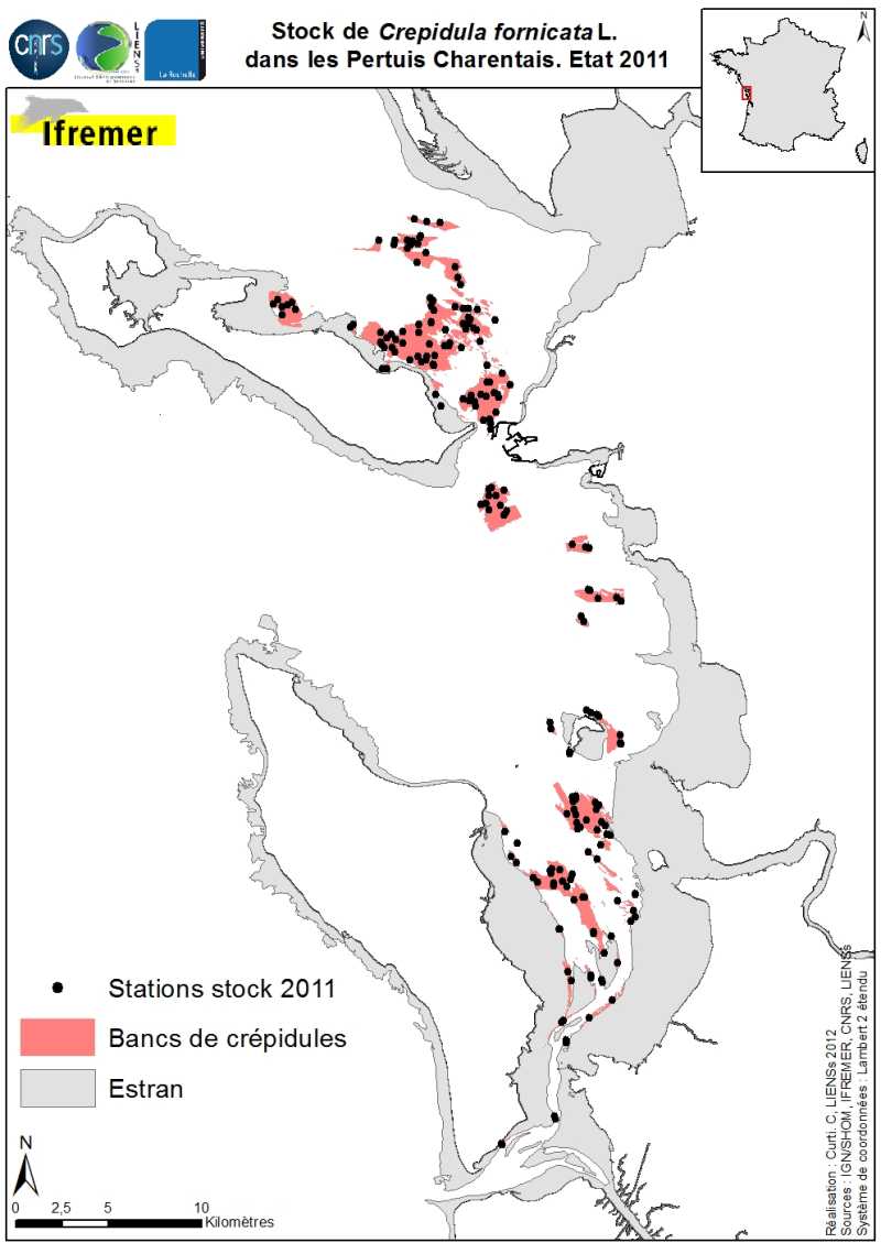
Stocks of Crepidula fornicata Linnaeus, 1758 in the Pertuis Charentais. Environmental state for 2011
Stocks (abundance and biomass) of the slipper limpet Crepidula fornicata Linnaeus, 1758 in the Pertuis Charentais shallows were estimated in 2011 and mapped (Sauriau et al., 2011). The influence of the estimate includes the Pertuis Breton, the eastern part Pertuis Antioch Fouras peninsula and the Bay of Marennes-Oléron where the latter earlier estimates are available. Contours and surface areas of the crepidula were previously determined by acoustic imaging performed aboard the VO/Haliotis in 2008 and 2009, interpreted and validated by spot sampling in 2009 (Curti, 2009). Sampling stocks of 2011 is based on a stratified random sample of 40 banks with a proportional distribution of sampling of 200 stations between banks. The listing for each crepidula bank stocks (abundance in millions, biomass in tonnes) both living and dead, these shells may provide support to potential new colonization.
Simple
- Date ( Creation )
- 2011-12-31T16:44:00
- Identifier
- FR-330-715-368-00198-ifr-CREPFOR-2011
- Purpose
- Ce shape a été créé dans le but de cartographier les stocks 2011 de la crépidule Crepidula fornicata dans l’ensemble des Pertuis Charentais depuis le Pertuis Breton, le Pertuis d’Antioche jusqu’en baie de Marennes-Oléron.
- Credit
- LIENSs/Ifremer : acquisition des données LIENSs-CNRS/Ifremer : Pierre-Guy Sauriau, Cécile Curti, chefs de mission LIENSs-CNRS-Université de la Rochelle : Pierre Guy Sauriau, Cécile Curti, numérisation et validation scientifique
- Status
- On going
Custodian
LIENSs, CNRS, Université de la Rochelle
-
P.-G. Sauriau
(
)
2 rue Olympe de Gouges 17000 La Rochelle
,
Point of contact
LIENSs, CNRS, Université de la Rochelle
-
P.-G. Sauriau
(
)
2 rue Olympe de Gouges 17000 La Rochelle
,
Principal investigator
Ifremer
-
O. Le Moine
(
)
Ifremer, Laboratoire Environnement-Ressources des Pertuis Charentais Station de la Tremblade Ronce-Les-Bains 17390 La Tremblade
,
- Maintenance and update frequency
- As needed
- Keywords ( Discipline )
-
- Benthos, Crepidula fornicata
- Keywords ( Place )
-
- Pertuis Charentais
- Keywords ( Stratum )
-
- 15 à 0 m (cote marine)
- Keywords ( Temporal )
-
- 2011
- Keywords ( Theme )
-
- Répartition des espèces
- Type de jeux de donnée ODATIS Type de jeux de donnée ODATIS ( Theme )
-
- /Processed data/Composite products
- Thématiques - SIMM Thématiques - SIMM ( Theme )
-
- /Etat du Milieu/Habitats
- Sous-regions marines Sous-regions marines ( Place )
-
- Bay of Biscay
- Use limitation
- Ce fichier est destiné à un usage personnel et non commercial. Pour tout usage autre que personnel, veuillez prendre contact avec le distributeur. Toute modification de cette donnée est soumise à une autorisation préalable. Pour cela, veuillez prendre contact avec le gestionnaire de la donnée.
- Access constraints
- Copyright
- Use constraints
- Copyright
- Other constraints
- Obligation de citation sur la carte : « Sources : P.-G. Sauriau, C. Curti, 2011 ; Réalisation : P.-G. Sauriau, C. Curti, 2012 ; produit numérique CNRS/LIENSs/Université de la Rochelle
- Other constraints
- Obligation de citation dans la bibliographie : Sauriau P.-G., Curti C., Cajeri P., Aubert F., Sauriau F., Sauriau M., Leguay D., Pineau D., Gouesbier C., Jourde J. & Latry L. (2011). Estimation du stock de crépidules dans les Pertuis Charentais. Rapport LIENSs, CNRS, Université de La Rochelle, La Rochelle, Contrat Ifremer 2011 5 53526118 : 47 p. Curti C. (2009). Cartographie des bancs de crépidules du bassin de Marennes-Oléron : analyse par imagerie acoustique et sondeur de sédiment. Mémoire Master professionnel « Environnement Marin », Université de la Méditerranée : 36 p.
- Spatial representation type
- Vector
- Denominator
- 200000
- Metadata language
- fr
- Character set
- UTF8
- Topic category
-
- Biota
- Environment description
- Acquisition : benne Smith McIntyre Traitement : import sous ArcGis 10.0
- Begin date
- 2010-09-01T16:57:00
- End date
- 2012-09-30T16:57:00
N
S
E
W
))
- Reference system identifier
- EPSG / WGS 84 (EPSG:4326) / 7.4
- Topology level
- Geometry only
- Geometric object type
- Surface
- Geometric object count
- 40
- Geometric object type
- Point
- Geometric object count
- 200
- Distribution format
-
-
shp
(
10
)
-
shp
(
10
)
- Hierarchy level
- Dataset
Conformance result
- Date ( Creation )
- 2012-01-16
- Explanation
- Non évalué
- Pass
- No
- Statement
- Non renseignée
- File identifier
- d295e6f6-731d-4dfe-95f7-81be627f7082 XML
- Metadata language
- fr
- Character set
- UTF8
- Hierarchy level
- Dataset
- Date stamp
- 2020-06-04T00:37:08
- Metadata standard name
- ISO 19115:2003/19139 - SEXTANT
- Metadata standard version
- 1.0
Overviews
Spatial extent
N
S
E
W
Provided by

Associated resources
Not available