 Mon GéoSource
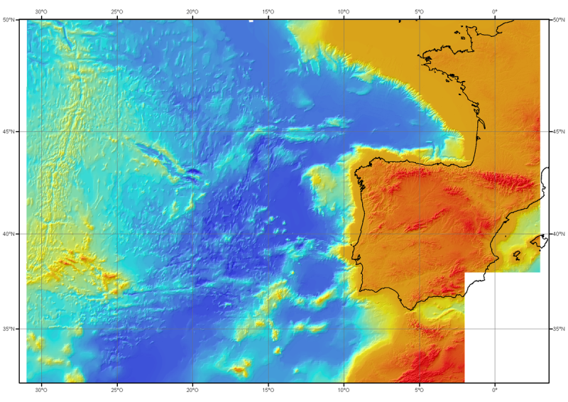
Bathy-morphology of the North-East Atlantic (2006 edition, resolution 1000 m)
Bathymetric model (DTM) of the North-East Atlantic, generated from conventional multibeam bathymetry data, prior to the year 2000.
The grid spacing is 1000 meters.
Bibliographic reference : Sibuet J.C. & al., (2004) - Carte bathymétrique de l'Atlantique nord-est et du golfe de Gascogne : implications cinématiques. Bull. Soc. géol. Fr.T. 175, n°5, pp. 429-442
Simple
- Alternate title
- Synthese_AtlantiqueNordEst_1000m_2004_BATHY
- Date ( Publication )
- 2004-10-01
- Date ( Creation )
- 2004-10-01
- Edition
- édition Ifremer
- Edition date
- 2004-10-01T00:00:00
- Identifier
- FR-330-715-368-00032-Synthese_AtlantiqueNordEst_1000m_2004_BATHY
- Identifier
- DOI:10.12770/e07a0ef0-a453-11de-8853-000086f6a603
- Presentation form
- Digital map
- Credit
- Ifremer, Géosciences Marines, 2004
- Status
- On going
0298224570
02 98 22 45 49
- Maintenance and update frequency
- Not planned
- Thèmes Sextant Thèmes Sextant ( Theme )
-
- /Physical Environment/Bathymetry/Digital Terrain Model
- GEMET - INSPIRE themes, version 1.0 GEMET - INSPIRE themes, version 1.0 ( Theme )
-
- Elevation
- external.theme.gemet external.theme.gemet ( Theme )
-
- seabed
- underwater morphology
- Keywords ( Theme )
-
- bathymetry
- Digital Terrain Model
- Keywords ( Place )
-
- North-East Atlantic
- Keywords ( Discipline )
-
- geophysics
- Sous-regions marines Sous-regions marines ( Place )
-
- Bay of Biscay
- Channel-North Sea
- Celtic Seas
- Thématiques - SIMM Thématiques - SIMM ( Theme )
-
- /Etat du Milieu/Bathymétrie
- Recherche
- Type de jeux de donnée ODATIS Type de jeux de donnée ODATIS ( Theme )
-
- /Processed data/Composite products
- Use limitation
- Commercial use is prohibited.
- Use limitation
- Change and distribution of data prohibited without the consent of the distributor.
- Use limitation
- Do not use for navigation
- Access constraints
- Other restrictions
- Use constraints
- Copyright
- Other constraints
- Required citation : SIBUET J.C. & al., Carte bathymétrique de l'Atlantique nord-est et du golfe de Gascogne : implications cinématiques. Bulletin de la Société Géologique de France, 2004, T. 175, n°5, pp. 429-442
- Spatial representation type
- Grid
- Denominator
- 2400000
- Metadata language
- fr
- Character set
- UTF8
- Topic category
-
- Elevation
- Description
- period of data acquisition
- Begin date
- 1970-01-01T15:53:00
- End date
- 2000-01-01T15:53:00
))
- Reference system identifier
- EPSG / WGS 84 / World Mercator (EPSG:3395) / 7.4
- Number of dimensions
- 2
- Dimension name
- Row
- Dimension size
- 2021
- Resolution
- 1000 mètre,
- Dimension name
- Column
- Dimension size
- 2861
- Resolution
- 1000 mètre,
- Cell geometry
- Point
- Transformation parameter availability
- No
Distributor
- OnLine resource
-
Campagne à la mer : Cadisar1
(
WWW:LINK
)
Campagne à la mer : Cadisar1
- OnLine resource
-
Campagne à la mer : ImagesV Leg 1-MD114
(
WWW:LINK
)
Campagne à la mer : ImagesV Leg 1-MD114
- OnLine resource
-
Campagne à la mer : ImagesV Leg 4-MD114
(
WWW:LINK
)
Campagne à la mer : ImagesV Leg 4-MD114
- OnLine resource
-
Campagne à la mer : Erable
(
WWW:LINK
)
Campagne à la mer : Erable
- OnLine resource
-
DOI of the dataset
(
WWW:LINK-1.0-http--metadata-URL
)
DOI of the dataset
- OnLine resource
- Synthese_AtlantiqueNordEst_1000m_2004_BATHY ( OGC:WMS )
- Protocol
- COPYFILE
- Name
- Synthese_AtlantiqueNordEst_1000m_2004_BATHY
- Hierarchy level
- Dataset
- Description
- vertical extent of the DTM and period of raw data acquisition
- Begin date
- 1970-01-01T15:58:00
- End date
- 2000-12-31T15:58:00
Vertical extent
- Minimum value
- -5994
- Maximum value
- 3593
Vertical CS
Vertical datum
- Statement
- Compilation of multibeam data and digitized historical maps
- Description
- Data processing and interpolation with GMT and Caraïbes software
- Description
- Mercator projection, reference latitude 46N, WGS_84 ellipsoid
- File identifier
- e07a0ef0-a453-11de-8853-000086f6a603 XML
- Metadata language
- fr
- Character set
- UTF8
- Hierarchy level
- Dataset
- Date stamp
- 2021-06-03T16:39:35
- Metadata standard name
- ISO 19115:2003/19139 - SEXTANT
- Metadata standard version
- 1.0
0298224570
Overviews
Spatial extent
Provided by
