 Mon GéoSource
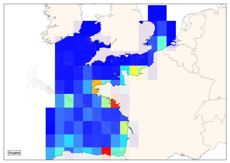
Spatial distribution of all data of the vertically integrated oxygen for the geographic area of the Bay of Biscay - English Channel
Spatial distribution of all oxygen data in degrees integrated vertically and horizontally for all sub-regions of the English Channel, the North Sea, the Celtic Seas and the Bay of Biscay.
Simple
- Date ( Creation )
- 2011-06-01
- Date ( Publication )
- 2011-06-01
- Identifier
- DOXY
- Credit
- Ifremer
Point of contact
IFREMER
-
Sourisseau Marc
02 98 22 45 48
Centre Bretagne - ZI de la Pointe du Diable - CS 10070 - 29280 Plouzané
,
Brest
,
France
02 98 22 43 61
02 98 22 45 48
- Thèmes Sextant Thèmes Sextant ( Theme )
-
- /Human Activities/Scientific Activities
- Keywords ( Theme )
-
- concentration
- nutrients
- monthly climatology
- GEMET - INSPIRE themes, version 1.0 GEMET - INSPIRE themes, version 1.0 ( Theme )
-
- Oceanographic geographical features
- Keywords ( Place )
-
- English Channel
- Bay of Biscay
- Sous-regions marines Sous-regions marines ( Place )
-
- Channel-North Sea
- Bay of Biscay
- Celtic Seas
- Access constraints
- Copyright
- Use constraints
- Copyright
- Classification
- Unclassified
- Spatial representation type
- Grid
- Distance
- 111120 metre
- Metadata language
- fr
- Character set
- UTF8
- Topic category
-
- Geoscientific information
N
S
E
W
))
- Begin date
- 1930-01-01T16:10:00
- End date
- 2010-01-01T16:10:00
- Reference system identifier
- EPSG / WGS84 géographiques / 7.4
- Distribution format
-
-
ESRI grid
(
ArcGIS 9.3.1
)
-
ESRI grid
(
ArcGIS 9.3.1
)
- OnLine resource
- site internet Ifremer dédié à la Directive Cadre Stratégie pour le Milieu Marin ( WWW:LINK )
- OnLine resource
-
carthothèque DCSMM
(
WWW:LINK
)
Spatio-temporal distribution of oxygen
- OnLine resource
- DCSMM_OXY_VERTI_MANCHE_GASC_R ( OGC:WMS )
- Hierarchy level
- Dataset
- Statement
-
Data from of the existing databases of the Quadriga, SeaDataNet, Somlit, Ices and the Modycott campaign.
Processed with Matlab to achieve a single file without duplicates.
Creation of a climatology baseline starting from the median vertical interpolation on a standard grid recovered through Levitus then refined with the ISAS tool adapted to the SLCA parameter.
- File identifier
- e0a28f76-5ffd-4fe6-b94c-7edd92f6c587 XML
- Metadata language
- fr
- Character set
- UTF8
- Hierarchy level
- Series
- Hierarchy level name
- Ensemble de jeux de données
- Date stamp
- 2020-06-04T01:14:35
- Metadata standard name
- ISO 19115:2003/19139 - SEXTANT
- Metadata standard version
- 1.0
Point of contact
Ifremer Brest - Geosciences Marines
-
Etienne Laffay
(
Coordination cartographique
)
BP 70
,
Plouzané
,
29280
,
France
Overviews
Spatial extent
N
S
E
W
Provided by

Associated resources
Not available