 Mon GéoSource
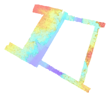
Bathymétrie - Eventail du Congo, site F (campagne CONGOLOBE, 2011)
Bathymétrie du site F du complexe de lobes de l'éventail du Congo (Campagne CONGOLOBE, 2011), au pas de 75 cm. Les données ont été acquises par le sondeur multifaisceaux Reson Seabat 7125 (400kHz) du ROV Victor 6000, opéré à partir du N/O Pourquoi Pas? Ce jeu de données correspond aux plongées 485 et 488 du ROV.
Description de la campagne :RABOUILLE Christophe (2011) CONGOLOBE cruise, RV Pourquoi pas ?, https://doi.org/10.17600/11030170
Projet CongoLobe, de l'ANR : https://anr.fr/Projet-ANR-11-BS56-0030
Publications :
- Rabouille C, Olu K, Baudin F, Khripounoff A, Dennielou B et al. 2017. The Congolobe project, a multidisciplinary study of Congo deep-sea fan lobe complex: Overview of methods, strategies, observations and sampling. Deep-Sea Research Part Ii-Topical Studies in Oceanography. 2017 Aug;142:7-24.
Open Access version : https://archimer.ifremer.fr/doc/00335/44580/
- Sen A, Dennielou B, Tourolle J, Arnaubec A, Rabouille C, Olu K. 2017. Fauna and habitat types driven by turbidity currents in the lobe complex of the Congo deep-sea fan. Deep-Sea Research Part Ii-Topical Studies in Oceanography.
Open Access version : https://archimer.ifremer.fr/doc/00385/49614/
Simple
- Date ( Revision )
- 2018-12-27
- Date ( Creation )
- 2013-01-11
- Date ( Publication )
- 2022-01-21
- Identifier
- FR-330715-368-00032-CONGOLOBE_Pl485_Pl488_75cm_BATHY
- Presentation form
- Digital model
- Credit
- UPMC Université Paris VI (Pierre et Marie Curie) / LSCE Centre national de la recherche scientifique, délégation régionale Ile-De-France secteur sud / Ifremer, Institut français de recherche pour l'exploitation de la mer
02 98 22 45 70
- Maintenance and update frequency
- As needed
- Keywords ( Discipline )
-
- Bathymétrie
- Keywords ( Place )
-
- Congo
- Keywords ( Temporal )
-
- 2012
- GEMET - INSPIRE themes, version 1.0 ( Theme )
-
- Altitude
- GEMET - Concepts, version 3.1 ( Theme )
-
- Fond marin
- Morphologie sous-marine
- Thèmes Sextant ( Theme )
-
- /Milieu physique/Bathymétrie/MNT
- Use limitation
- CC BY. Licence Creative Commons Attribution 4.0 International https://creativecommons.org/licenses/by/4.0/
- Use limitation
- Ne pas utiliser pour la navigation
- Access constraints
- Other restrictions
- Use constraints
- License
- Other constraints
- Pas de restriction d'accès public
- Use constraints
- Restricted
- Spatial representation type
- Grid
- Distance
- 0.75 m
- Denominator
- 1500
- Metadata language
- Françaisfr
- Character set
- UTF8
- Topic category
-
- Elevation
- Environment description
- Version 6.2 (Build 9200) ; Esri ArcGIS 10.8.1.14362
))
- Reference system identifier
- EPSG / WGS84 - World Mercator (EPSG3395) latitude 6°Sud / 8.2.6
- Number of dimensions
- 2
- Dimension name
- Column
- Dimension size
- 6023
- Resolution
- 0.750000 m
- Dimension name
- Row
- Dimension size
- 5289
- Resolution
- 0.750000 m
- Cell geometry
- Area
- Transformation parameter availability
- Yes
- Checkpoint Availability
- No
Center point
- Point in Pixel
-
- Center
- Distribution format
-
-
Jeu de données Raster
()
-
Jeu de données Raster
()
- OnLine resource
- Campagne CONGOLOBE ( WWW:LINK )
- OnLine resource
- CONGOLOBE_Pl485_Pl488_75cm_BATHY ( OGC:WMS )
- Protocol
- COPYFILE
- Name
- CONGOLOBE_Pl485_Pl488_75cm_BATHY
- OnLine resource
- Digital Object Identifier (DOI) ( WWW:LINK-1.0-http--metadata-URL )
- Hierarchy level
- Dataset
- Statement
-
Profils1 à 6 de la plongée 485-5 et profils 1 à 4 de la plongée 488-8.
Rapport de traitement: Saout Johan (2014). Projet "ZAIRE" : Traitement des données Multi-faisceaux de la campagne "Congolobes". DIT.REM/GM/CTDI-20140114-CG01.
- Attribute description
- Profondeur
- Content type
- Image
- Descriptor
- Band_1
- Maximum value
- -4840.164062
- Minimum value
- -4902.390137
- Bits per value
- 32
- Triangulation indicator
- No
- Radiometric calibration data availability
- No
- Camera calibration information availability
- No
- Film distortion information availability
- No
- Lens distortion information availability
- No
- File identifier
- eab39d3a-2165-457b-a4ea-848fa32d2360 XML
- Metadata language
- Françaisfr
- Character set
- UTF8
- Hierarchy level
- Dataset
- Hierarchy level name
- dataset
- Date stamp
- 2022-08-19T12:16:46.554Z
- Metadata standard name
- ISO 19115:2003/19139 - SEXTANT
- Metadata standard version
- V. 1.2
Overviews
Spatial extent
Provided by
