 Mon GéoSource
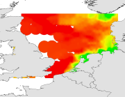
Physical environment - In situ data - Surface salinity collected during the International Bottom Trawl Survey in summer (1991-2009)
Simple
- Autres appellations ou acronymes
- IBTS_environment_geostatS
- Date ( Publication )
- 2012-04-10T00:00:00
- Identificateur
- CHARM_SSAL_IBTS_1991-2009
- Forme de la présentation
- Carte numérique
- Autres informations de référence
- Source CHARM Consortium
- Reconnaissance
- IFREMER
- Reconnaissance
- CHARM consortium
- Etat
- Finalisé
- Fréquence de mise à jour
- Lorsque nécessaire
- Thèmes Sextant ( Thème )
-
- /Physical Environment/Physical Habitats
- Mots clés ( Discipline )
-
- Environment data set
- CHARM
- external.theme.gemet ( Thème )
-
- ressource halieutique
- GEMET - INSPIRE themes, version 1.0 ( Thème )
-
- Oceanographic geographical features
- Limitation d'utilisation
- research-only
- Contraintes d'accès
- Licence
- Autres contraintes
- Has to be cited this way in maps : "Source CHARM Consortium"
- Autres contraintes
- Has to be cited this way in bibliography : "Carpentier A, Martin CS, Vaz S (Eds.), 2009. Channel Habitat Atlas for marine Resource Management, final report / Atlas des habitats des ressources marines de la Manche orientale, rapport final (CHARM phase II). INTERREG 3a Programme, IFREMER, Boulogne-sur-mer, France. 626 pp. & CD-rom"
- Type de représentation spatiale
- Raster
- Dénominateur de l'échelle
- 2500
- Langue
- fr
- Langue
- en
- Jeu de caractères
- Utf8
- Catégorie ISO
-
- Océans
- Biote
- Environnement
- Description de l'environnement de travail
- Microsoft Windows XP ; ESRI ArcGIS 9.x
- Identifiant géographique
- Eastern English Channel
))
- Date de début
- 1989-01-01
- Date de fin
- 2007-12-31
- Nom du système de référence
- WGS 84 (EPSG:4326)
- Dimensions
- 2
- Noms des axes
- Axe - X
- Nombre de pixel
- 768
- Résolution
- 0.009 degree
- Noms des axes
- Axe - Y
- Nombre de pixel
- 660
- Résolution
- 0.009 degree
- Type de raster
- Surface
- Disponibilité des paramètres de transformation
- Non
Distributeur
- Ressource en ligne
-
CHARMIII_IBTSQ3_mssal_q3
(
OGC:WMS
)
Mean
- Ressource en ligne
-
CHARMIII_IBTSQ3_sdssal_q3
(
OGC:WMS
)
Standard deviation
- Ressource en ligne
-
CHARMIII_SSAL_IBTS_1991
(
OGC:WMS
)
1991
- Ressource en ligne
-
CHARMIII_SSAL_IBTS_1992
(
OGC:WMS
)
1992
- Ressource en ligne
-
CHARMIII_SSAL_IBTS_1993
(
OGC:WMS
)
1993
- Ressource en ligne
-
CHARMIII_SSAL_IBTS_1994
(
OGC:WMS
)
1994
- Ressource en ligne
-
CHARMIII_SSAL_IBTS_1995
(
OGC:WMS
)
1995
- Ressource en ligne
-
CHARMIII_SSAL_IBTS_1996
(
OGC:WMS
)
1996
- Ressource en ligne
-
CHARMIII_SSAL_IBTS_1997
(
OGC:WMS
)
1997
- Ressource en ligne
-
CHARMIII_SSAL_IBTS_1998
(
OGC:WMS
)
1998
- Ressource en ligne
-
CHARMIII_SSAL_IBTS_1999
(
OGC:WMS
)
1999
- Ressource en ligne
-
CHARMIII_SSAL_IBTS_2000
(
OGC:WMS
)
2000
- Ressource en ligne
-
CHARMIII_SSAL_IBTS_2001
(
OGC:WMS
)
2001
- Ressource en ligne
-
CHARMIII_SSAL_IBTS_2002
(
OGC:WMS
)
2002
- Ressource en ligne
-
CHARMIII_SSAL_IBTS_2003
(
OGC:WMS
)
2003
- Ressource en ligne
-
CHARMIII_SSAL_IBTS_2004
(
OGC:WMS
)
2004
- Ressource en ligne
-
CHARMIII_SSAL_IBTS_2005
(
OGC:WMS
)
2005
- Ressource en ligne
-
CHARMIII_SSAL_IBTS_2006
(
OGC:WMS
)
2006
- Ressource en ligne
-
CHARMIII_SSAL_IBTS_2007
(
OGC:WMS
)
2007
- Ressource en ligne
-
CHARMIII_SSAL_IBTS_2008
(
OGC:WMS
)
2008
- Ressource en ligne
-
CHARMIII_SSAL_IBTS_2009
(
OGC:WMS
)
2009
- Protocole
- COPYFILE
- Nom
- 1991
- Description
- 1991
- Protocole
- COPYFILE
- Nom
- 1992
- Description
- 1992
- Protocole
- COPYFILE
- Nom
- 1993
- Description
- 1993
- Protocole
- COPYFILE
- Nom
- 1994
- Description
- 1994
- Protocole
- COPYFILE
- Nom
- 1995
- Description
- 1995
- Protocole
- COPYFILE
- Nom
- 1996
- Description
- 1996
- Protocole
- COPYFILE
- Nom
- 1997
- Description
- 1997
- Protocole
- COPYFILE
- Nom
- 1998
- Description
- 1998
- Protocole
- COPYFILE
- Nom
- 1999
- Description
- 1999
- Protocole
- COPYFILE
- Nom
- 2000
- Description
- 2000
- Protocole
- COPYFILE
- Nom
- 2001
- Description
- 2001
- Protocole
- COPYFILE
- Nom
- 2002
- Description
- 2002
- Protocole
- COPYFILE
- Nom
- 2003
- Description
- 2003
- Protocole
- COPYFILE
- Nom
- 2004
- Description
- 2004
- Protocole
- COPYFILE
- Nom
- 2005
- Description
- 2005
- Protocole
- COPYFILE
- Nom
- 2006
- Description
- 2006
- Protocole
- COPYFILE
- Nom
- 2007
- Description
- 2007
- Protocole
- COPYFILE
- Nom
- 2008
- Description
- 2008
- Protocole
- COPYFILE
- Nom
- 2009
- Description
- 2009
- Niveau
- Jeu de données
- Généralités sur la provenance
- The data was extracted by year and quarter from the ICES oceanographic database.
- Description
- Geostatistical interpolation : the spatial variation of data were analysed using GENSTAT (GENSTAT 7 Committee, 2004), which is a GENeral STATistics package including the main geostatistical tools. It computes experimentala variograms, fits these with various authorised mathematical models and uses them to calculate kriged estimates on a fine regular grid (of latitudes and longitudes). The grid of points was imported into ArcMap and interpolated with the Spatial Analyst extension in order to create a continuous raster of 1 km² resolution. The resulting maps illustrate the spatial distributions and the variations over time for variables studied in CHARM's area. For legends of maps, approximates of the 5th and the 95th quantiles were used for the minimales and maximales values respectively. Average and standard deviation maps were computed based on all interpolated maps over all the period studied
- Description
- North Sea oceanography
- Identifiant de la fiche
- 5116d93a-590d-4bc5-9d0a-96a3ac955267 XML
- Langue
- en
- Jeu de caractères
- Utf8
- Type de ressource
- Jeu de données
- Date des métadonnées
- 2020-06-04T00:41:07
- Nom du standard de métadonnées
- ISO 19115:2003/19139 - SEXTANT
- Version du standard de métadonnées
- 1.0
Aperçus
Étendue spatiale
Fourni par
