 Mon GéoSource
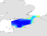
Species and habitats - Merlangius merlangus - Immature - Mean abundance in October, standard deviation maps during CGFS (1988-2009)
Biologic data have been expressed in abundance (numbers or density values (nbr/km²)) and always required to be log-transformed using a log10(x+1) transformation. Abundance mean (mean) and standard deviation (st) have been calculated.
Simple
- Autres appellations ou acronymes
- CGFS_species_geostatS
- Date ( Publication )
- 2012-04-13T00:00:00
- Identificateur
- CHARM_MERNMER_0_CGFS_MEAN_SD
- Forme de la présentation
- Carte numérique
- Autres informations de référence
- Source CHARM Consortium
- Reconnaissance
- IFREMER
- Reconnaissance
- CHARM consortium
- Etat
- Finalisé
- Fréquence de mise à jour
- Lorsque nécessaire
- Thèmes Sextant ( Thème )
-
- /Biological Environment/Species/Fish Species of Commercial Interest
- Mots clés ( Discipline )
-
- Species data set
- CHARM
- Merlan
- Whiting
- european squid
- GEMET - INSPIRE themes, version 1.0 ( Thème )
-
- Répartition des espèces
- external.theme.gemet ( Thème )
-
- ressource halieutique
- Limitation d'utilisation
- research-only
- Contraintes d'accès
- Licence
- Autres contraintes
- Has to be cited this way in maps : "Source CHARM Consortium"
- Autres contraintes
- Has to be cited this way in bibliography : "Carpentier A, Martin CS, Vaz S (Eds.), 2009. Channel Habitat Atlas for marine Resource Management, final report / Atlas des habitats des ressources marines de la Manche orientale, rapport final (CHARM phase II). INTERREG 3a Programme, IFREMER, Boulogne-sur-mer, France. 626 pp. & CD-rom"
- Type de représentation spatiale
- Raster
- Dénominateur de l'échelle
- 2500
- Langue
- fr
- Langue
- en
- Jeu de caractères
- Utf8
- Catégorie ISO
-
- Océans
- Biote
- Environnement
- Description de l'environnement de travail
- Microsoft Windows XP ; ESRI ArcGIS 9.x
- Identifiant géographique
- Eastern English Channel
N
S
E
W
))
- Date de début
- 1988-01-01
- Date de fin
- 2006-12-31
- Nom du système de référence
- WGS 84 (EPSG:4326)
- Dimensions
- 2
- Noms des axes
- Axe - X
- Nombre de pixel
- 1288
- Résolution
- 0.009 degree
- Noms des axes
- Axe - Y
- Nombre de pixel
- 618
- Résolution
- 0.009 degree
- Type de raster
- Surface
- Disponibilité des paramètres de transformation
- Non
Distributeur
- Ressource en ligne
- Site Sextant CHARM ( WWW:LINK )
- Niveau
- Jeu de données
- Généralités sur la provenance
- The survey extends from the Eastern English Channel to the south of the North Sea, which corresponds to ICES divisions VIId and IVc. The study area is divided into rectangles of 15¿ latitude and 15¿ longitude using a systematic sampling strategy. The sampling gear is a high opening bottom trawl well adapted for catching demersal species, with a 10 mm mesh size (side knot) for catching juveniles. This sampling gear is polyvalent and is well adapted to the varying seabed types encountered in the study area.One or two 30 minutes hauls are performed within each rectangle of the CGFS grid (two in the coastal zone and one offshore). The fishing hauls are chosen using professional fishing plans or found by prospecting. The fishing method is standardised: sampling stations have been each year at similar locations and identical sampling gear is used. Since 1997, temperature and salinity (surface and bottom) are measured using a probe attached on the headrope of the trawl. At each sampling station, all the fish species are sorted, weighed, counted and measured. For certain commercial species, bony structures (otoliths) are collected.
- Description
- For each species, the average (mean) and the standard deviation (sd) are computed from kriged annual maps over all the available period. The sum of all annual kriging error over the same period (v) is also computed. The resulting grids of points were imported into ArcMap and interpolated with the Spatial Analyst extension in order to create a continuous raster of 1 km² resolution. The resulting maps illustrate the average pattern (mean), its interannual variability (sd) and its overall interpolation error (summed kriging error) of each parameter.
- Description
- CGFS, annual scientific survey of IFREMER
- Identifiant de la fiche
- 98534679-ffa8-438b-abdf-f0d4b763227e XML
- Langue
- en
- Jeu de caractères
- Utf8
- Type de ressource
- Jeu de données
- Date des métadonnées
- 2020-06-04T00:22:51
- Nom du standard de métadonnées
- ISO 19115:2003/19139 - SEXTANT
- Version du standard de métadonnées
- 1.0
Aperçus
Étendue spatiale
N
S
E
W
Fourni par

Ressources associées
Not available