 Mon GéoSource
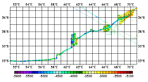
Southwest indian ridge between 57°E and 70°E - 500m
Acquirement of multibim bathymetric datas along the south-west indian ridge between 57°E ans the Rodrigues triple junction.
Simple
- Date ( Creation )
- 2000-08-04
- Identifier
- IFR_MBAN_DORSALES_INDIEN_SWIR57_70_BATHY_500_R
- Identifier
- DOI:10.12770/f4e288cd-6291-4f53-b597-9209e24db202
- Credit
- The project is part of the national program Dorsales and represents the French contribution to the InterRidge Data Banks project (see InterRidge News 1997, vol. 6/1 and 1999, vol. 8/1).
Publisher
Ifremer
+33 (0)2 98.22.46.44
http://www.ifremer.fr/sismer/
Centre IFREMER de Brest BP 70
,
PLOUZANE
,
29280
,
France
+33 (0)2 98.22.49.16
+33 (0)2 98.22.46.44
http://www.ifremer.fr/sismer/
- Thèmes Sextant Thèmes Sextant ( Theme )
-
- /Physical Environment/Bathymetry/Digital Terrain Model
- GEMET - INSPIRE themes, version 1.0 GEMET - INSPIRE themes, version 1.0 ( Theme )
-
- Elevation
- Type de jeux de donnée ODATIS Type de jeux de donnée ODATIS ( Theme )
-
- /Processed data/Composite products
- Thématiques - SIMM Thématiques - SIMM ( Theme )
-
- /Environmental Status/Geology
- /Environmental Status/Bathymetry
- Sous-regions marines Sous-regions marines ( Place )
-
- /Overseas France/Indian Ocean
- Thématiques - SIMM Thématiques - SIMM ( Theme )
-
- Research
- Use limitation
- CC-BY (Creative Commons - Attribution)
- Access constraints
- Other restrictions
- Use constraints
- License
- Other constraints
- Mendel, V., and Sauter, D., 1997 - Seamount volcanism at the super slow spreading Southwest Indian Ridge between 57˚E and 70˚E. Geology, 25, p. 99-102. (2) Parson L., Sauter D., Mendel V., Patriat P and Searle R., 1997. Evolution of the axial geometry of the South-West Indian Ridge between the Melville fracture zone and the Indian Ocean Triple Junction - Implications for segmentation on very slow-spreading ridges. Mar. Geophys. Res., 19, p. 535-552. (3) Patriat P., Sauter D., Munschy M. and Parson L.M. , 1997, A survey of the South-West Indian Ridge between the Atlantis II fracture zone and the Indian Ocean Triple Junction: regional setting and large scale segmentation. Mar. Geophys. Res., 19, p. 457-480.
- Spatial representation type
- Grid
- Denominator
- 25000
- Metadata language
- fr
- Character set
- UTF8
- Topic category
-
- Elevation
N
S
E
W
))
- Begin date
- 1984-01-01
- End date
- 1993-12-31
- Reference system identifier
- EPSG / WGS 84 (EPSG:4326) / 8.6
- Number of dimensions
- 2
- Dimension name
- Column
- Resolution
- 0.004983 degres
- Dimension name
- Row
- Resolution
- 0.004333 degres
- Cell geometry
- Area
- Distribution format
-
-
(
)
-
(
)
- OnLine resource
- DOI de la campagne - HYDROAMSTERDAM ( WWW:LINK )
- OnLine resource
- DOI de la campagne - CAPSING ( WWW:LINK )
- OnLine resource
- DOI de la campagne - RODRIGUEZ(1ER LEG) ( WWW:LINK )
- OnLine resource
- DOI de la campagne - RODRIGUEZ(2EME LEG) ( WWW:LINK )
- OnLine resource
-
DOI du jeu de données
(
WWW:LINK-1.0-http--metadata-URL
)
DOI du jeu de données
- OnLine resource
-
IFR_MBAN_DORSALES_INDIEN_SWIR57_70_BATHY_500_R
(
OGC:WMS
)
Bathymétrie à 500m de résolution
OnLine resource
No information provided.
- Protocol
- COPYFILE
- Name
- IFR_MBAN_DORSALES_INDIEN_SWIR57_70_BATHY_500_R
- Description
- Bathymétrie 500m - format .tif
- Protocol
- COPYFILE
- Name
- IFR_MBAN_DORSALES_INDIEN_SWIR57_70_BATHY_500_R_GRD
- Description
- Bathymétrie 500m - format .grd
- Hierarchy level
- Dataset
- Statement
- Sources : Données de la campagne J. Charcot 1988, données Seabeam
- Description
- 0 spline en tension (surface)
- Rationale
- Interpolation
Content Information
No information provided.
- File identifier
- f4e288cd-6291-4f53-b597-9209e24db202 XML
- Metadata language
- fr
- Character set
- UTF8
- Hierarchy level
- Dataset
- Date stamp
- 2022-04-06T12:53:59.24Z
- Metadata standard name
- ISO 19115:2003/19139 - SEXTANT
- Metadata standard version
- 1.0
Overviews
capture1.png
Spatial extent
N
S
E
W
Provided by

Associated resources
Not available