 Mon GéoSource
/Environmental Status/Pollution
Type of resources
Available actions
Topics
INSPIRE themes
Keywords
Contact for the resource
Provided by
Representation types
Update frequencies
status
Scale
-
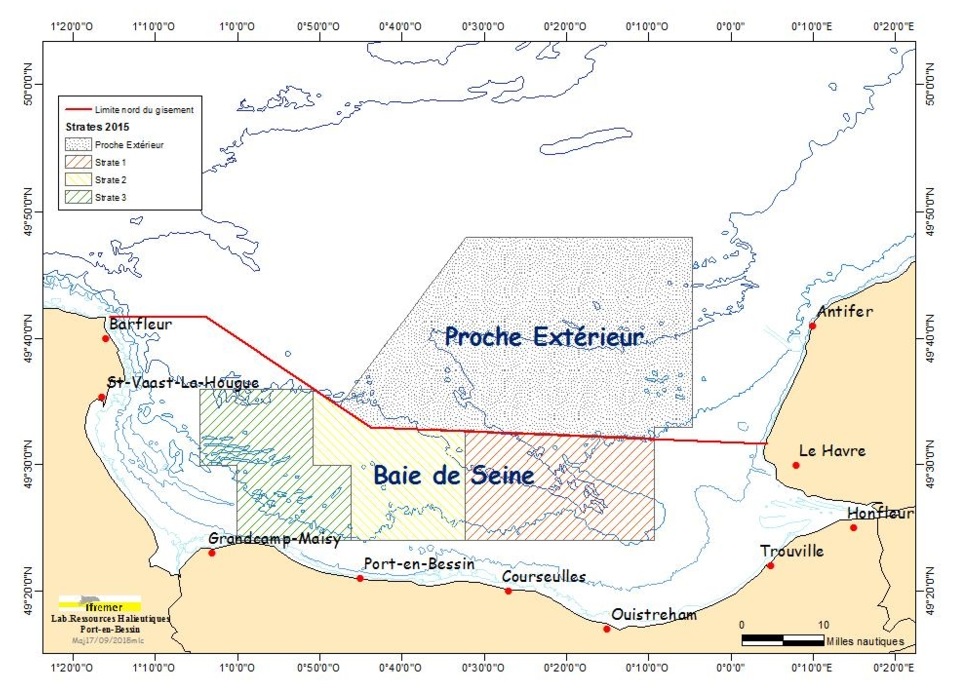
The COMOR cruises, which took place on the Thalia, aim to assess the abundance of the scallop stock (and if necessary to determine the presence of toxic algae) in the Seine Bay.
-
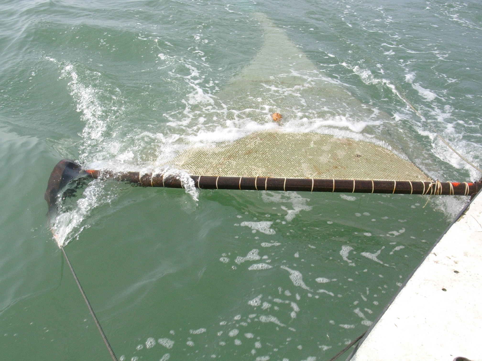
The objective of this cruise, which has been taking place in the English Channel - Baie de somme since 1980, over 5 days in September, is to evaluate the natural multi-year fluctuations of the stands and to analyze the possible impact of the nuclear power plant on the marine environment and resources. It makes it possible to determine annual indices of abundance and distribution of flatfish and other species (shrimp, pout, whiting).
-
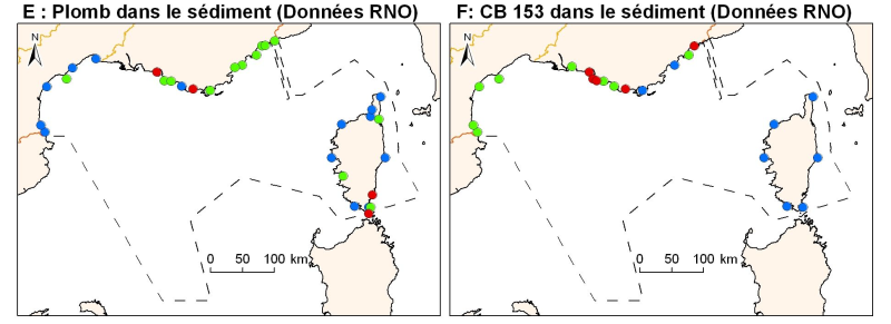
Concentrations of metals, organochlorines in surficial sediments (1st cm) in the Mediterranean coast, from RNO data.
-

The definitive coastal information system, Quadrige stores coastal observation and monitoring network data. In order to manage coastal monitoring data, Ifremer developed the Quadrige² information system. Quadrige is one element of the Water Information System (SIE) http:// www.eaufrance.fr, et à ce titre, contribue aux travaux du Secrétariat d'Administration National des Données Relatives à l'Eau (SANDRE) http://www.sandre.eaufrance.fr. Quadrige Marine Zones is a reference source unique to the Quadrige system. It is used to break down the coast of the French mainland and overseas territories into large areas and to connect each one with observation and monitoring locations.
-
In order to manage coastal monitoring data, Ifremer has developed the Quadrige information system which connects a database to a wide array of tools for interpreting and designing information products. Quadrige is just one element of the Water Information System (SIE) www.eaufrance.fr and, as such, contributes toward the work of the French National Adminitrative Service for Water-Related Data (SANDRE) www.sandre.eaufrance.fr. The main aim of the Quadrige thematic databank is to manage and enhance data from coastal observation and monitoring networks. On a national level, Quadrige is today designated by the French Environment Ministry as the definitive information system for coastal waters, and the tool is therefore common to all of those working in the marine environment sector. The Quadrige databank is composed of data from the Quadrige database and products described or made available on the Envlit website. The Quadrige database contains results about most physical, chemical and biological environmental description parameters. The first data for example dates back to 1974 for the parameters relating to general water quality and contaminants, 1987 for phytoplankton and phycotoxins, 1989 for microbiology, from the early 2000s for the benthic zone. The data is permanently being updated. In Quadrige, an observation location is a geographical location where observations, measurements and/or samples will be taken. These locations can be located in a unique way thanks to their appearance on a map (polygon, line or point). A measurement location can be used by multiple programmes.
-
Since 2008, the Coastal Chemical Contamination Observation Network (ROCCH) has taken over from RNO (French National Observation Network for Quality in Marine Environments), which had existed since 1974. ROCCH aims to meet national, community and international obligations relating to monitoring chemicals in marine environments. It is therefore more of a control network than a heritage network as RNO once was. The backbone of ROCCH is to apply the European Water Framework Directive (WFD) and to meet the obligations set out in OSPAR Conventions and in Barcelona. As the WFD insisted on decentralization, ROCCH has gone from having just one project leader (the Ministry for the Environment) to having many decision-makers (water agencies, DIREN etc.). Chemical analyses are no longer conducted by Ifremer alone, but are attributed to other partners following calls for tender. ROCC also includes the monitoring of chemicals in shellfish production areas for the Food safety agency (DGAL) and the Ministry for Agriculture and Fisheries. Monitoring focuses on the three regulated metals: mercury, lead and cadmium in the given areas. Monitoring of these chemical contaminants is conducted in the three marine matrices: water, biota and sediment. Testing also includes imposex, the biological effect of tributyltin (TBT), as required by the OSPAR convention.
-
The French national network (REMI) includes a regular monitoring system and a warning system: - The regular monitoring system checks that the level of microbiological contamination in each production area remains within the limits set by the classification defined in the prefectural decree and tests unusual occurrences of contamination. - The warning system is triggered when results of the monotoring programme exceed or are at risk of exceeding the norms defining the quality classes and thresholds, or in case of contamination risk (pollution spillage, storms, etc.), or even in the case of a suspected or confirmed epidemic in shellfish.
-
REPHY is a national network covering the coast of the French mainland along with that of three of its overseas departments: Martinique, Guadeloupe and Reunion Island. The aims are as follows: - to observe all phytoplankton species in the coastal waters and to monitor events such as coloured water, exceptional blooms, and the proliferation of species which are toxic or disruptive to marine fauna, - Particularly to monitor species producing toxins which are dangerous to shellfish consumers . These objectives are complementary, as the regular monitoring of all phytoplankton species makes it possible to detect known toxic and invasive species, but also to detect potentially toxic species. It is the presence of these toxic species in the water which triggers the monitoring of toxins in shellfish. The mission of REPHY is to monitor shellfish in their natural environment (such as parks and deposits). For shellfish removed from marine environments (that is to say in shellfish logistics establishments or on markets prior to export), national monitoring and control plans are organised by the General Food Directive at the French Ministry of Agriculture. Analyses are performed by the accredited departmental veterinary laboratories as organised by the National Reference Laboratory from the French Food Safety Agency.
-
The definitive coastal information system, Quadrige stores coastal observation and monitoring network data. In order to manage coastal monitoring data, Ifremer developed the Quadrige² information system. Quadrige is one element of the Water Information System (SIE) http:// www.eaufrance.fr, et à ce titre, contribue aux travaux du Secrétariat d'Administration National des Données Relatives à l'Eau (SANDRE) http://www.sandre.eaufrance.fr. Quadrige Marine Zones is a reference source unique to the Quadrige system. It is used to break down the coast of the French mainland and overseas territories into large areas and to connect each one with observation and monitoring locations.