 Mon GéoSource
2010-2012
Type of resources
INSPIRE themes
Provided by
Years
Formats
Representation types
Update frequencies
status
Scale
-

A la demande de l’Agence des Aires Marines Protégées, un inventaire cartographique des habitats des sites Natura 2000 en mer de l’estuaire de la Gironde et des Pertuis charentais a été réalisé afin d’établir un état initial de référence des milieux naturels. Est ici présenté l’inventaire cartographique dévolu aux zones intertidales meubles et rocheuses des Pertuis Charentais comprenant le littoral depuis la Tranche sur Mer jusqu’à Bonne Anse. S’inspirant des protocoles REBENT et MESH, trois méthodes complémentaires ont été combinées pour cartographier ces habitats intertidaux (Cajeri et al., 2012). Elles combinent les inventaires terrain avec relevés GPS différentiel, la télédétection couplant analyse d’ortho littorales et de scènes du satellite KOMPSAT-2 puis l’intégration sous système d’information géographique (SIG). Le rendu cartographique est basé sur la typologie EUNIS de niveau 4. Les structures délimitées sur photographies aériennes et validées par les inventaires terrain sont interprétées à partir de scènes satellite soumises à classification hiérarchique permettant une discrimination en termes de nature de sol, type de végétation et présence de mares. La compilation des informations est réalisée sous SIG en respectant les contraintes d’échelle et de topologie. Cette étude permet de combler un vide majeur de connaissances en particulier pour les habitats rocheux et les habitats d’espèces dans les Pertuis Charentais, les habitats de substrats meubles ayant été décrits par Hily (1976) et interprétés en typologie EUNIS par le REBENT. La carte proposée des habitats intertidaux n’est cependant pas définitive. Elle devrait bénéficier d’ajouts apportés à la typologie EUNIS par l’incorporation de nouveaux habitats en cours de validation à l’échelle européenne.
-
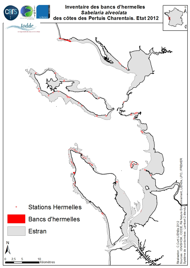
The geographical distribution of the main Sabellaria Hermelles alveolata beds (Linné, 1767) from the coast of the Pertuis Charentais was compiled from 2010 to 2012. The inventory focuses on the tidal beds (+ 6-0 m marine coast) and compiles two cartographic sources from the project CARTHAM Natura 2000 at sea of the Agency of Marine Protected Areas: 1) Hermelles inventories made on 2011 by the Association IODDE on the west of Oleron Island and 2) mapping inventory of intertidal marine habitats by LIENSs (in cooperation with CREOCEAN, Ré Nature Environnement, GEO-Transfert et la LPO Moëze-Oléron). Methodologies used by IODDE on Oléron combine ground truths with reports with Geographic Information System (GIS). The methodologies used by LIENSs to estimate the extension of the intertidal habitats throughout the Pertuis Charentais combine aerial image analysis, remote sensing, field validations by differential GPS and thematic analysis using GIS (Cajeri et al., 2012). It is during these ground truths that the presence of tackles or small Hermelles reefs was noted. The IODDE results have allowed an almost exhaustive inventory of Hermelles reefs west of Oleron. Those of LIENSs have clarified the distribution of Hermelles on most of the Pertuis Charentais foreshores.
-
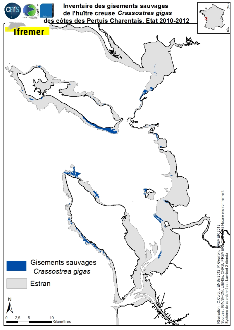
The geographical distribution of the main sources of wild Pacific oysters (Crassostrea gigas) (Thunberg, 1793) on the coasts of the Pertuis Charentais was compiled from 2010 to 2012. The inventory focuses on natural foreshore deposits (+ 6-0 m sea coast) and compiles two cartographic sources: 1) quantitative inventories made in 2010 by Ifremer from the Tranche sur Mer (Vendée) to Vaux-sur-Mer in 21 representative sites to estimate wild stocks of Pacific oysters and 2) inventory mapping of intertidal marine habitats mainly made by LIENSs (in cooperation with CREOCEAN, IODDE, Ré Nature Environnement and GEO-Transfert) under the project CARTHAM Natura 2000at sea of the Agency of Marine Protected Areas. Methodologies used by Ifremer to estimate the areas colonized combine thematic analysis in Geographic Information System (GIS) and field validations (Soletchnik et al., 2012). The methodologies used to estimate LIENSs extension of the intertidal habitat of the oysters combined aerial image analysis, remote sensing, field validations and thematic analysis using GIS (Cajeri et al., 2012).