 Mon GéoSource
Geolocation data from the VMS
Simple
- Date ( Publication )
- 2022-02-08
- Identifier
- 0c644ef6-30a8-4f0e-a227-abe57ad16943
- Presentation form
- Digital profile
- Credit
- IFREMER, DPMA
- Status
- On going
- Maintenance and update frequency
- Continual
- Keywords ( Theme )
-
- VMS
- Fishing vessels
- Fishing effort
- Position
- GEMET - INSPIRE themes, version 1.0 GEMET - INSPIRE themes, version 1.0 ( Theme )
-
- Environmental monitoring facilities
- Sous-regions marines Sous-regions marines ( Place )
-
- /Metropolitan France/Bay of Biscay
- /Metropolitan France/Bay of Biscay
- /Metropolitan France/Western Mediterranean
- /Metropolitan France/Celtic Seas
- /Metropolitan France/Channel-North Sea
- DCSMM : Descripteurs DCSMM : Descripteurs ( Theme )
-
- D3: Commercially Exploited Species
- DCSMM : Méthodes de recueil des données DCSMM : Méthodes de recueil des données ( Theme )
-
- Piégeage, capture
- Observation directe
- Thèmes Sextant Thèmes Sextant ( Theme )
-
- /Human Activities/Industrial Fishing
- SIH - Façade maritime SIH - Façade maritime ( Theme )
-
- Manche - Mer du Nord
- Guadeloupe
- Guyane
- La Réunion
- Martinique
- Mayotte
- Saint-Pierre-et-Miquelon
- Méditerranée
- Atlantique
- SIH - Types de jeu de données SIH - Types de jeu de données ( Theme )
-
- /Declarative data/VMS
- Access constraints
- Restricted
- Use constraints
- Restricted
- Metadata language
- fr
- Character set
- UTF8
- Topic category
-
- Biota
- Begin date
- 1970-01-01
))
))
))
))
))
))
))
))
))
- Supplemental Information
-
Funders :
IFREMER
Direction des Pêches Maritimes et de l'Aquaculture (DPMA)
- Distribution format
-
-
(
)
-
(
)
- OnLine resource
- Information on VMS data on the SIH website ( WWW:LINK )
- OnLine resource
- Access to SIH VMS data ( WWW:LINK )
- OnLine resource
- Digital Object Identifier (DOI) ( WWW:LINK-1.0-http--metadata-URL )
- Hierarchy level
- Dataset
Conformance result
- Date ( Creation )
- 2012-01-16
- Explanation
- Non rated
- Pass
- No
- Statement
-
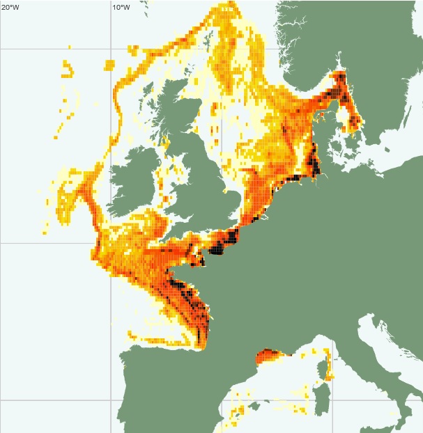
The Vessel Monitoring System (VMS) is an EU satellite-based fishing vessel monitoring system that provides data on vessel position, course and speed to the fisheries authorities at regular intervals. It is mandatory for EU-flagged professional fishing vessels over 12 metres since 1 January 2012 (over 15 metres since 2005, over 18 metres since 2004). In addition, non-EU vessels of this size must be equipped with a functioning satellite tracking device when in EU waters.
The National Fisheries Monitoring Centre based in Etel (CNSP 56) transmits VMS data from French and foreign vessels to Ifremer on a daily basis to carry out its fisheries expertise in the framework of the Common Fisheries Policy, and not for control purposes. For this scientific use, the VMS data are confidential and access is strictly reserved for Ifremer staff. The use of the data in a different context is subject to prior agreement from the Direction des Pêches Maritimes et de l'Aquaculture (DPMA - Ministry of Agriculture and Food).
VMS data improves knowledge of the fine spatial distribution of fishing effort and catches, and therefore contributes to the assessment of the state of exploited resources and their management.
• Precision on the type of data:
Position data (under the WGS84 geodetic system, with a margin of error of less than 100 metres and a confidence interval of 99%), speed and instantaneous route of French (whatever their area of activity) and foreign (when they are in the French EEZ) professional fishing vessels are transmitted daily by the CNSP 56.
• Declared parameter(s) :
The VMS beacons transmit the following elements of the vessel at least every hour in French waters (compared to 2 hours for other European countries), sometimes every quarter of an hour for certain fisheries:
- flag
- name
- international registration
- external marking
- position (longitude and latitude)
- date and time of issue
- instantaneous speed
- heading
• Resolution of parameter(s) :
The data is banked by vessel, position, date and time.
• Format(s):
The available data exists in the format: csv.
- File identifier
- 0c644ef6-30a8-4f0e-a227-abe57ad16943 XML
- Metadata language
- fr
- Character set
- UTF8
- Hierarchy level
- Dataset
- Date stamp
- 2022-02-17T15:06:39.698Z
- Metadata standard name
- ISO 19115:2003/19139 - SEXTANT
- Metadata standard version
- 1.0
Overviews
Spatial extent
Provided by
