 Mon GéoSource
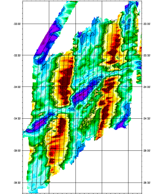
Southwest indian ridge between 54°30°E and 57°25'E - 120m
Geophysical survey of 2 sections of the South West Indian Ridge from the axis to a distance of about 100 km, corresponding to more than 10Ma. Profiles were 4 miles apart to ensure correct interpretation of gravimetry and magnetism data. The first zone studied was located around 38S and 50E, and was along a straight axis with shallow depths. The second zone was located around 34S and 56E, and was along a highly fragmented and very oblique axis.
Simple
- Date ( Creation )
- 2002-01-30
- Identifier
- IFR_MBAN_DORSALES_INDIEN_54_57_BATHY_120_R
- Identifier
- DOI:10.12770/0e272094-3c67-49d6-ba5c-a73875c849d9
- Credit
- The project is part of the national program Dorsales and represents the French contribution to the InterRidge Data Banks project (see InterRidge News 1997, vol. 6/1 and 1999, vol. 8/1).
Publisher
Ifremer
+33 (0)2 98.22.46.44
http://www.ifremer.fr/sismer/
Centre IFREMER de Brest BP 70
,
PLOUZANE
,
29280
,
France
+33 (0)2 98.22.49.16
+33 (0)2 98.22.46.44
http://www.ifremer.fr/sismer/
- Thèmes Sextant Thèmes Sextant ( Theme )
-
- /Physical Environment/Bathymetry/Digital Terrain Model
- GEMET - INSPIRE themes, version 1.0 GEMET - INSPIRE themes, version 1.0 ( Theme )
-
- Elevation
- Type de jeux de donnée ODATIS Type de jeux de donnée ODATIS ( Theme )
-
- /Processed data/Composite products
- Thématiques - SIMM Thématiques - SIMM ( Theme )
-
- /Etat du Milieu/Géologie
- /Etat du Milieu/Bathymétrie
- Sous-regions marines Sous-regions marines ( Place )
-
- /Outre-mer/Océan Indien
- Thématiques - SIMM Thématiques - SIMM ( Theme )
-
- Recherche
- Use limitation
- CC-BY (Creative Commons - Attribution)
- Access constraints
- Other restrictions
- Use constraints
- License
- Other constraints
- D. Sauter, P. Patriat, C. Rommevaux-Jestin, M. Cannat, A. Briais, the Gallieni Shipboard Scientific Party, The Southwest Indian Ridge between 49˚15’E and 57˚E: focused accretion and magma redistribution, Earth Planet. Sci. Lett. 192 (2001) 303-317
- Spatial representation type
- Grid
- Denominator
- 25000
- Metadata language
- fr
- Character set
- UTF8
- Topic category
-
- Elevation
N
S
E
W
))
- Reference system identifier
- EPSG / WGS 84 (EPSG:4326) / 8.6
- Number of dimensions
- 2
- Dimension name
- Column
- Resolution
- 0.001316 degres
- Dimension name
- Row
- Resolution
- 0.001083 degres
- Cell geometry
- Area
- Distribution format
-
-
(
)
-
(
)
- OnLine resource
-
MOHNS_BATHY
(
OGC:WMS
)
Bathymetry (WMS)
- Protocol
- FILE
- Name
- MOHNS_BATHY
- Description
- Bathymétrie - format .tif and .grd
- OnLine resource
-
DOI du jeu de données
(
WWW:LINK-1.0-http--metadata-URL
)
DOI du jeu de données
- Protocol
- COPYFILE
- Name
- IFR_MBAN_DORSALES_INDIEN_54_57_BATHY_120_R_GRD
- Description
- Bathymétrie 120m - format .grd
- OnLine resource
- DOI de la campagne - GALLIENI ( WWW:LINK )
- Hierarchy level
- Dataset
- Statement
- Sources : Données de la campagne J. Charcot 1988, données Seabeam
- Description
- 0 spline en tension (surface)
- Rationale
- Interpolation
Content Information
No information provided.
- File identifier
- 0e272094-3c67-49d6-ba5c-a73875c849d9 XML
- Metadata language
- fr
- Character set
- UTF8
- Hierarchy level
- Dataset
- Date stamp
- 2020-08-31T11:24:01
- Metadata standard name
- ISO 19115:2003/19139 - SEXTANT
- Metadata standard version
- 1.0
Overviews
Capture.PNG
Spatial extent
N
S
E
W
Provided by

Associated resources
Not available