 Mon GéoSource
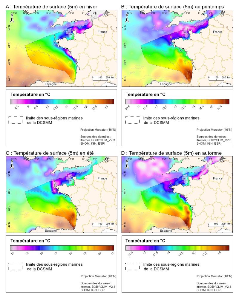
Hydrological climatology Channel - Bay of Biscay: Seasonal temperature at a depth of 5m (BOBYCLIM_V2.3)
3D seasonal temperature range (in ° C) obtained by objective analysis (interpolation) of the raw data in situ, at a depth of 5m.
Within the Bay of Biscay Challenge and the programme of the Operational Coastal Oceanographic Centre Prévimer, the services of SISMER DYNECO-PHYSED of IFREMER have built a joint hydrological database of the Bay of Biscay, from CTD measurements, Bouteilles, XBT / MBT and Profileurs from multiple global data centres to achieve a climatological atlas of the region for temperature and salinity.
Simple
- Date ( Creation )
- 2011-06-27
- Identifier
- BOBYCLIM_V2.3_climato
- Credit
- Ifremer, BOBYCLIM_V2.3
- Thèmes Sextant Thèmes Sextant ( Theme )
-
- /Physical Environment/Climatology
- Keywords ( Theme )
-
- climatologie saisonnière ; température de surface
- Keywords ( Discipline )
-
- hydrologie
- GEMET - INSPIRE themes, version 1.0 GEMET - INSPIRE themes, version 1.0 ( Theme )
-
- Caractéristiques géographiques océanographiques
- Keywords ( Place )
-
- Manche
- Gascogne
- Sous-regions marines Sous-regions marines ( Place )
-
- Bay of Biscay
- Channel-North Sea
- Celtic Seas
- Access constraints
- Copyright
- Use constraints
- Copyright
- Classification
- Restricted
- Spatial representation type
- Grid
- Metadata language
- fr
- Character set
- UTF8
- Topic category
-
- Climatology, meteorology, atmosphere
- Oceans
))
- Reference system identifier
- EPSG / WGS84 géographiques / 7.4
- Distribution format
-
-
Netcdf
(
)
-
Netcdf
(
)
- OnLine resource
- Bobyclim - Bay of Biscay Climatology ( WWW:LINK )
- OnLine resource
- site internet Ifremer dédié à la Directive Cadre Stratégie pour le Milieu Marin ( WWW:LINK )
- OnLine resource
-
carthothèque DCSMM
(
WWW:LINK
)
Régime de la température et de la salinité
- Hierarchy level
- Dataset
- Statement
-
http://www.ifremer.fr/climatologie-gascogne/index.php
Bay of Biscay climatology is the synthesis of almost all in situ data for the area of the Bay of Biscay to 15 ° W, for the 20th century, primarily collected by IFREMER, the SHOM, and the WDCA (approximately 100000 stations T and/or S for the period from 1862 to 2006). It provides information on temperature and salinity of the entire water column. The atlas obtained by objective analysis has the distinction of having respected the different scales depending on the area, shelf and abyssal plain, with a variable radius of influence depending on the area. A fine scale (small radius of influence) on the coast shows local effects such as plumes, up swellings and a large scale (large radius of influence) on the plain providing the longer signal linked to the large scale circulation.
- File identifier
- 0faf5c13-f14a-4973-8da7-d78925ba383a XML
- Metadata language
- fr
- Character set
- UTF8
- Hierarchy level
- Series
- Hierarchy level name
- Ensemble de jeux de données
- Date stamp
- 2020-06-04T01:04:59
- Metadata standard name
- ISO 19115:2003/19139 - SEXTANT
- Metadata standard version
- 1.0
Overviews
Spatial extent
Provided by
