 Mon GéoSource
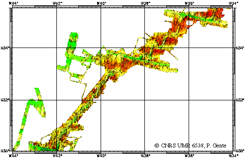
Mid-Atlantic Ridge between 30 and 35°N - 500m
Identification d'une manière géophysique (magnétisme, gravimétrie et bathymétrie), les segments de la dorsale Atlantique entre 30 et 35N, actuels et passés (jusqu'à 10 millions d'années), en précisant leur géométrie et leurs frontières.
Simple
- Date ( Creation )
- 1998-01-01
- Identifier
- IFR_MBAN_DORSALES_ATLAN_30_35_BATHY_500_R
- Identifier
- DOI:10.12770/19694f8f-31db-40d2-b2b0-6629839e3d0b
- Credit
- The project is part of the national program Dorsales and represents the French contribution to the InterRidge Data Banks project (see InterRidge News 1997, vol. 6/1 and 1999, vol. 8/1).
Publisher
Ifremer
+33 (0)2 98.22.46.44
http://www.ifremer.fr/sismer/
Centre IFREMER de Brest BP 70
,
PLOUZANE
,
29280
,
France
+33 (0)2 98.22.49.16
+33 (0)2 98.22.46.44
http://www.ifremer.fr/sismer/
- Thèmes Sextant Thèmes Sextant ( Theme )
-
- /Physical Environment/Bathymetry/Digital Terrain Model
- GEMET - INSPIRE themes, version 1.0 GEMET - INSPIRE themes, version 1.0 ( Theme )
-
- Elevation
- Thématiques - SIMM Thématiques - SIMM ( Theme )
-
- /Etat du Milieu/Bathymétrie
- Type de jeux de donnée ODATIS Type de jeux de donnée ODATIS ( Theme )
-
- /Processed data/Model outputs
- Thématiques - SIMM Thématiques - SIMM ( Theme )
-
- Recherche
- Use limitation
- CC-BY (Creative Commons - Attribution)
- Access constraints
- Other restrictions
- Use constraints
- License
- Other constraints
- THIBAUD R., GENTE P. and MAIA M., 1998. A systematic analysis of the Mid-Atlantic Ridge morphology and gravity between 15°N and 40°N : constraints of the thermal structure. J. Geophys. Res., 103, 24223-24243
- Spatial representation type
- Grid
- Denominator
- 25000
- Metadata language
- fr
- Character set
- UTF8
- Topic category
-
- Elevation
N
S
E
W
))
- Reference system identifier
- EPSG / WGS 84 (EPSG:4326) / 8.6
- Number of dimensions
- 2
- Dimension name
- Column
- Resolution
- 0.00449113 degres
- Dimension name
- Row
- Resolution
- 0.0045214 degres
- Cell geometry
- Area
- Distribution format
-
-
(
)
-
(
)
- OnLine resource
-
IFR_MBAN_DORSALES_ATLAN_30_35_BATHY_500_R
(
OGC:WMS
)
Bathymetry (WMS)
- Protocol
- FILE
- Name
- IFR_MBAN_DORSALES_ATLAN_30_35_BATHY_500_R
- Description
- Bathymétrie - format .tif and .grd
- OnLine resource
-
DOI du jeu de données
(
WWW:LINK-1.0-http--metadata-URL
)
DOI du jeu de données
- Protocol
- COPYFILE
- Name
- IFR_MBAN_DORSALES_ATLAN_30_35_BATHY_500_R_GRD
- Description
- Bathymétrie 500m - format .grd
- OnLine resource
- DOI de la campagne - FARA - SEADMA I ( WWW:LINK )
- Hierarchy level
- Dataset
- Statement
- Sources : Données de la campagne J. Charcot 1988, données Seabeam
Content Information
No information provided.
- File identifier
- 19694f8f-31db-40d2-b2b0-6629839e3d0b XML
- Metadata language
- fr
- Character set
- UTF8
- Hierarchy level
- Dataset
- Date stamp
- 2020-08-31T11:20:30
- Metadata standard name
- ISO 19115:2003/19139 - SEXTANT
- Metadata standard version
- 1.0
Overviews
Capture.PNG
Spatial extent
N
S
E
W
Provided by

Associated resources
Not available