 Mon GéoSource
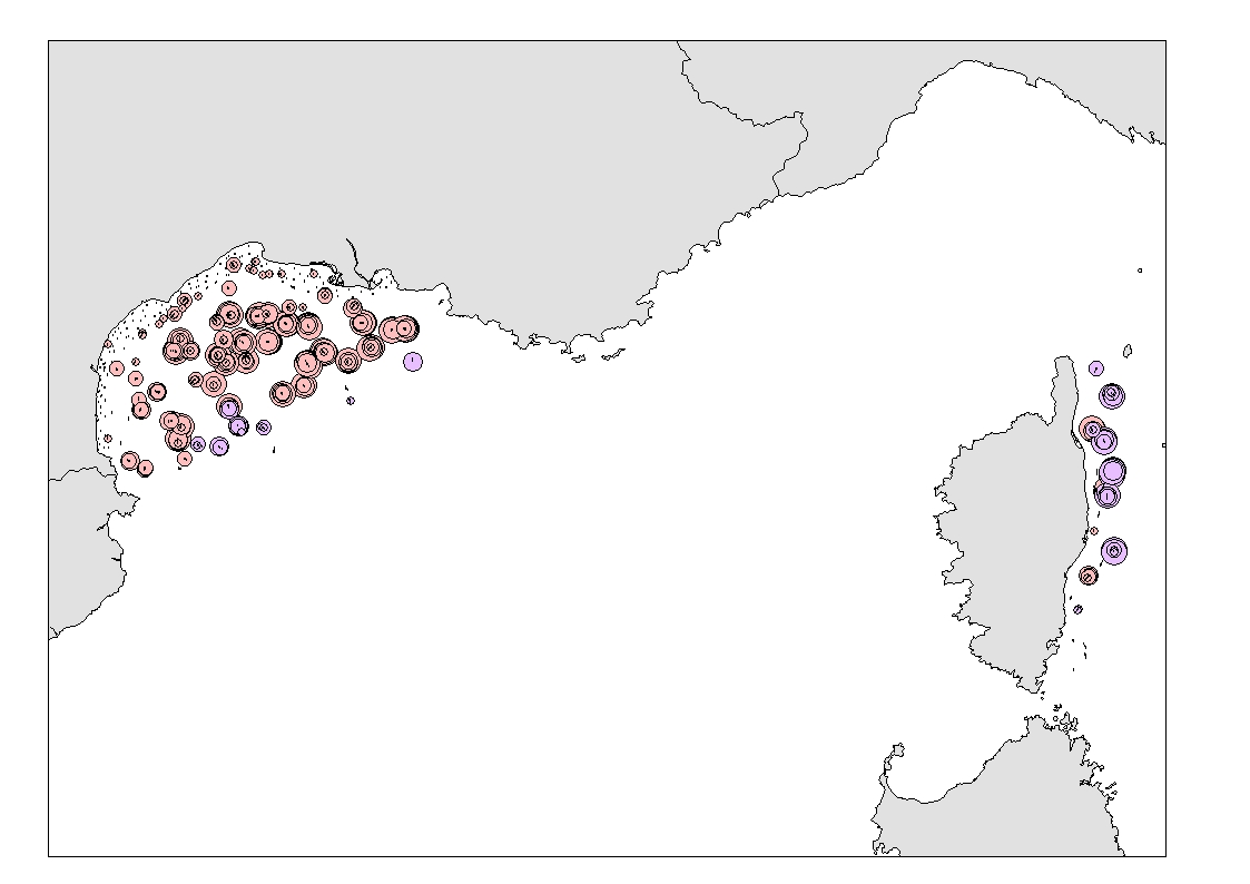
Funiculina quadrangularis (Pennatulacea) and Isidella elongata (Alcyonacea) distributions from scientific trawl surveys by-catches
Simple
- Date ( Publication )
- 2020-03-15
- Identifier
- DOI:10.12770/27ad8f32-bd15-417c-b08d-064a713c9409
- Credit
- Marbec
04 99 57 32 95
- Thèmes Sextant Thèmes Sextant ( Theme )
-
- /Biological Environment/Species/Rare, Protected Species, and Species in Danger of Extinction
- GEMET - INSPIRE themes, version 1.0 GEMET - INSPIRE themes, version 1.0 ( Theme )
-
- Species distribution
- DCSMM : Descripteurs DCSMM : Descripteurs ( Theme )
-
- D1: Coastal benthic habitats
- Sous-regions marines Sous-regions marines ( Place )
-
- /Metropolitan France/Western Mediterranean
- Keywords
-
- MSFD - Marine Strategy Framework Directive
- Benthic habitats
- VME - Vulnerable Marine Ecosystem
- Thématiques - SIMM Thématiques - SIMM ( Theme )
-
- /Environmental Status/Habitats
- Cadre Réglementaire - SIMM Cadre Réglementaire - SIMM ( Theme )
-
- Directive Cadre Stratégie pour le Milieu Marin (DCSMM)
- Ocean Hackathon - Ville Ocean Hackathon - Ville ( Place )
-
- Toulon
- Sète
- Use limitation
- CC-BY-NC-SA (Creative Commons - Attribution, No commercial usage, Sharing under the same conditions)
- Access constraints
- Other restrictions
- Use constraints
- Copyright
- Other constraints
-
Refer to MEDITS survey DOI
JADAUD Angélique (1994) MEDITS, https://doi.org/10.18142/7
VAZ Sandrine (2018) NOURMED, https://doi.org/10.18142/296
- Unique resource identifier
- https://doi.org/10.18142/296
- Association Type
- Cross reference
- Initiative Type
- Platform
- Unique resource identifier
- https://doi.org/10.18142/7
- Association Type
- Cross reference
- Initiative Type
- Platform
- Spatial representation type
- Vector
- Metadata language
- en
- Character set
- UTF8
- Topic category
-
- Biota
))
- Begin date
- 2012-06-01
- End date
- 2019-06-30
- Reference system identifier
- EPSG / WGS 84 (EPSG:4326) / 7.4
- Geometric object type
- Point
- Distribution format
-
-
(
)
-
(
)
- OnLine resource
-
IFR_IDEM_FUNIC_DENSITY
(
OGC:WMS
)
Funiculina quadrangularis (Pennatulacea) - Density
- Protocol
- FILE
- Name
- IFR_IDEM_FUNIC_DENSITY
- Description
- Funiculina quadrangularis (Pennatulacea) - Density
- OnLine resource
-
IFR_IDEM_FUNIC_BIOMASS
(
OGC:WMS
)
Funiculina quadrangularis (Pennatulacea) - Biomass
- Protocol
- FILE
- Name
- IFR_IDEM_FUNIC_BIOMASS
- Description
- Funiculina quadrangularis (Pennatulacea) - Biomass
- OnLine resource
-
IFR_IDEM_ISID_DENSITY
(
OGC:WMS
)
Isidella elongata (Alcyonacea) - Density
- Protocol
- FILE
- Name
- IFR_IDEM_ISID_DENSITY
- Description
- Isidella elongata (Alcyonacea) - Density
- OnLine resource
-
IFR_IDEM_ISID_BIOMASS
(
OGC:WMS
)
Isidella elongata (Alcyonacea) - Biomass
- Protocol
- FILE
- Name
- IFR_IDEM_ISID_BIOMASS
- Description
- Isidella elongata (Alcyonacea) - Biomass
- OnLine resource
-
DOI of the dataset
(
WWW:LINK-1.0-http--metadata-URL
)
DOI of the dataset
- Hierarchy level
- Dataset
Conformance result
- Date ( Publication )
- 2010-12-08
- Explanation
- See the referenced specification
- Statement
-
Bottom and beam trawling mostly targets fish and cephalopods while mega-zooplancton and most other benthic invertebrates are considered as by-catches of this fishing technique. The mesh size of bottom trawl, generally decreasing from opening to cod-end, and the ground gear used (usually only scratching the seabed surface) result in mostly mega-(>2cm) epifauna being captured. Although bottom trawl is seldom recognised as a valid sampling device for benthic invertebrate species, such observations are nonetheless believed to be particularly relevant as 1) they represent the benthic fauna fraction the most likely affected by bottom fishing 2) they integrate assemblages’ composition over large areas (1-4 km long and 3-20 m large) and are more representative of larger scale habitat structure and 3) they are particularly suited to collect over-dispersed or motile species.
IFREMER contributes to the collection of basic biological data in the french waters of the Mediterranean through its annual bottom trawl survey MEDITS (Mediterranean International Trawl Survey, carried out in June since 1994) and beam trawl survey NOURMED (Nourriceries Méditerranée, carried out in September since 2018) on board of the RV L'Europe.
For MEDITS, the sampling gears used an internationally standardised bottom trawl (GOC73), well adapted for catching demersal species (in particular fish and cephalopods), with a 10 mm mesh size at the cod-end for catching juveniles. The sampling strategy was using standard 30 or 60 minutes hauls (above and below 200m depth respectively) at 4 knots speed during daylight, evenly distributed over the whole study area. Demersal species and megafauna/epifauna caught in the bottom trawl were sorted, identified, counted and weighed (MEDITS, 2017). For NOURMED, the sampling gear was a standardised 3m beam trawl (CP3M), designed for catching benthic species (in particular flat fish and juveniles), with a 10 mm mesh size at the cod-end. The sampling strategy was using standard 15 minutes hauls at 2 knots speed during daylight, evenly distributed over the whole study area. Benthic species and megafauna/epifauna caught in the beam trawl were sorted, identified, counted and weighed (Vaz et al., 2019)
The present dataset focuses on vulnerable benthic invertebrates and is composed of one attribute table. It gives information about each operation (survey, date, location, gear type, swept area in km², horizontal opening in m, depth in m). Species catch were raised as total number or total weight (g) per km². When broken, species could not be counted and the value “1” was used to mark the presence of the species in the catch. Absence from the catch are reported as 0.
MEDITS (2017) MEDITS - International Bottom Trawl Survey in the Mediterranean : Instruction Manual Version 9.
Vaz Sandrine, Brind'Amour Anik, Delaunay Damien, Baudrier Jerome (2019). Rapport de campagne de nourriceries côtières : Campagne NOURMED 2018 . R.RBE / MARBEC-2019 . https://archimer.ifremer.fr/doc/00506/61742/
- File identifier
- 27ad8f32-bd15-417c-b08d-064a713c9409 XML
- Metadata language
- en
- Character set
- UTF8
- Hierarchy level
- Dataset
- Date stamp
- 2022-07-20T14:21:25.076Z
- Metadata standard name
- ISO 19115:2003/19139 - SEXTANT
- Metadata standard version
- 1.0
Overviews
Spatial extent
Provided by
