 Mon GéoSource
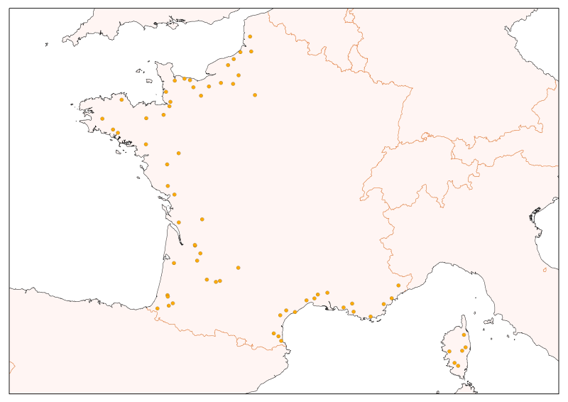
Flow gauging stations of the French rivers – Along the English Channel-Atlantic and Mediterranean
Selection of flow gauging stations of the French rivers (accessible via the central bank administered by the HYDRO SCHAPI) on the basis of hydrological function and monitoring stations.
The data bank HYDRO stores measurements of water depth (variable time step) from 3500 stations (including 2400 which are currently in service) located on French rivers and provides access to descriptive data stations (main purpose, precise location, measurement quality, history, data available ...)
Simple
- Date ( Revision )
- 2008-01-01
- Identifier
- FA_FM_StationsHydro_wgs84
- Credit
- Central service for Hydrometeorology and support for flood forecasting
- Thèmes Sextant Thèmes Sextant ( Theme )
-
- /Physical Environment/Terrestrial Hydrography/Hydrographic Network
- Keywords ( Theme )
-
- stations jaugeage
- streamflow
- Hydro data bank, Sandre, Schapi
- GEMET - INSPIRE themes, version 1.0 GEMET - INSPIRE themes, version 1.0 ( Theme )
-
- Installations de suivi environnemental
- Sous-regions marines Sous-regions marines ( Place )
-
- /Métropole
- Access constraints
- Copyright
- Use constraints
- Copyright
- Classification
- Unclassified
- Spatial representation type
- Vector
- Metadata language
- fr
- Character set
- UTF8
- Topic category
-
- Inland waters
- Location
))
- Reference system identifier
- EPSG / WGS84 géographiques / 7.4
- Distribution format
-
-
shape ESRI
(
ArcGIS 9.3.1
)
-
shape ESRI
(
ArcGIS 9.3.1
)
- OnLine resource
- site internet Ifremer dédié à la Directive Cadre Stratégie pour le Milieu Marin ( WWW:LINK )
- OnLine resource
-
carthothèque DCSMM
(
WWW:LINK
)
streamflow
- OnLine resource
- http://www.hydro.eaufrance.fr/ ( WWW:LINK )
- OnLine resource
-
Geoportail
(
WWW:LINK
)
Stations hydrométriques Métropole (geoportail, SANDRE)
- Hierarchy level
- Dataset
- Statement
-
Who provides data to the Hydro data bank?
It is mainly state departments, regional offices of Environment, flood forecasting services, departmental directorates for agriculture and forestry, water agencies, but also Electricité de France or research organization (CEMAGREF, universities, ...), as well as landscaping companies (la Compagnie d'aménagement des coteaux de Gascogne, la Compagnie nationale du Rhône, la Société du canal de Provence, la Compagnie d'aménagement du Bas-Rhône-Languedoc...).
These data producers install monitoring stations in the river, ensuring their maintenance, collect data, and check the feed the data bank. They make the gauging right at measuring stations and establish calibration curves that are also in the data bank. Then they validate and possibly correct the data. They are responsible for and ensure the data quality.
The Central Hydrometeorological Service and Support to Flood Forecasting Service (Ministry of Ecology and Sustainable Development) located in Toulouse, administers and manages the data bank services related to HYDRO. It also ensures the changes.
- File identifier
- 290b802d-418f-49c1-8c40-676ccd6f5d0a XML
- Metadata language
- fr
- Character set
- UTF8
- Hierarchy level
- Dataset
- Hierarchy level name
- Jeu de données
- Date stamp
- 2020-06-04T01:13:31
- Metadata standard name
- ISO 19115:2003/19139 - SEXTANT
- Metadata standard version
- 1.0
Overviews
Spatial extent
Provided by
