 Mon GéoSource
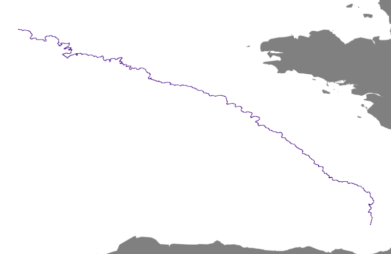
Continental shelf break in the Bay of Biscay
This is the path of the continental shelf break of the Bay of Biscay’s northwestern border.
Simple
- Alternate title
- FR-330-715-368-00032-Rebord_plateau_GDG_Arc_wgs84
- Date ( Creation )
- 2008-03-01T13:10:00
- Identifier
- FR-330-715-368-00032-Rebord_plateau_GDG_Arc_wgs84
- Presentation form
- Digital map
- Credit
- Ifremer, Géosciences Marines
- Status
- On going
Author
IFREMER
-
Satra Le Bris Catherine
02 98 22 45 70
Centre Bretagne - ZI de la Pointe du Diable - CS 10070 - 29280 Plouzané
,
Brest
,
France
02 98 22 46 32
02 98 22 45 70
- Maintenance and update frequency
- As needed
- Thèmes Sextant Thèmes Sextant ( Theme )
-
- /Physical Environment/Sedimentology Geology/Geomorphology
- Keywords ( Theme )
-
- Morphology
- Sedimentology
- Keywords ( Place )
-
- Bay of Biscay
- Atlantic
- Keywords ( Discipline )
-
- geophysics
- external.theme.gemet external.theme.gemet ( Theme )
-
- morphology underwater
- GEMET - INSPIRE themes, version 1.0 GEMET - INSPIRE themes, version 1.0 ( Theme )
-
- Geology
- Sous-regions marines Sous-regions marines ( Place )
-
- Bay of Biscay
- Use limitation
- Restricted access
- Access constraints
- Other restrictions
- Use constraints
- Restricted
- Other constraints
- Obligation de citation : Bourillet J-F., Reynaud J.-Y., Baltzer A. and Zaragosi S., 2003. The “Fleuve Manche”: the sub-marine sedimentary features from the outer shelf to the deep-sea fans. Journal of Quaternary Science, 18(3-4): 261-282.
- Spatial representation type
- Vector
- Denominator
- 100000
- Metadata language
- fr
- Character set
- UTF8
- Topic category
-
- Oceans
- Geoscientific information
N
S
E
W
))
- Reference system identifier
- 4326
- Topology level
- Geometry only
- Geometric object type
- Curve
- Geometric object count
- 1
Distributor
Distributor
Ifremer - Centre de Brest
-
Sextant server administrator
(
Appointed custodian for digital data
)
- Name
- fichier Shape ESRI
- Version
- ArcGIS 9.3.1
- OnLine resource
- DCSMM_REBORD_PLATEAU_GDGASC_A ( OGC:WMS )
- Hierarchy level
- Dataset
- Statement
-
Shelf edges extracted from the GIS linear morphology layer of the Gulf of Biscay.
Morphological interpretation of imagery, bathymetry and slope in the Bay of Biscay.
- Description
- The border of the shelf-slope is selected at 2° from the DTM Atlantic EEZ.
- File identifier
- 2cbb2286-07ec-417a-b725-7fc74f0cc470 XML
- Metadata language
- fr
- Character set
- UTF8
- Hierarchy level
- Dataset
- Date stamp
- 2020-06-04T00:54:14
- Metadata standard name
- ISO 19115:2003/19139 - SEXTANT
- Metadata standard version
- 1.0
Point of contact
IFREMER
-
Satra Le Bris Catherine
02 98 22 45 70
Centre Bretagne - ZI de la Pointe du Diable - CS 10070 - 29280 Plouzané
,
Brest
,
France
02 98 22 46 32
02 98 22 45 70
Overviews
Spatial extent
N
S
E
W
Provided by

Associated resources
Not available