 Mon GéoSource
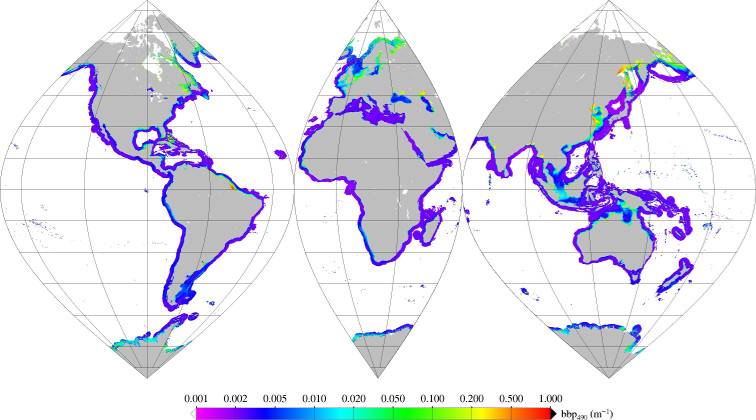
GlobCoast Monthly mean of particulate backscattering coefficient (bbp) at 490nm
Monthly mean of backscattering coefficient (bbp) at 490nm (2002-2012) for coastal areas, at global scale, for MERIS sensor, with POLYMER atmospheric corrections.
Ref: Loisel in prep.
Simple
- Date ( Publication )
- 2016-06-29
- Identifier
- LOG_GLOBCOAST_MO_BBP490_MERIS_FR
- Credit
- Université du Littoral Côte d'Opale - Laboratoire d'Océanologie et Géosciences
- Thèmes Sextant Thèmes Sextant ( Theme )
-
- /Imagery/Satellite Imagery
- GEMET - INSPIRE themes, version 1.0 GEMET - INSPIRE themes, version 1.0 ( Theme )
-
- Hydrography
- Keywords
-
- Open data
- Cadre Réglementaire - SIMM Cadre Réglementaire - SIMM ( Theme )
-
- Directive Cadre pour la Planification de l'Espace Maritime (DCPEM)
- Directive Cadre Stratégie pour le Milieu Marin (DCSMM)
- Type de jeux de donnée ODATIS Type de jeux de donnée ODATIS ( Theme )
-
- /Remote sensing
- Thématiques - SIMM Thématiques - SIMM ( Theme )
-
- /Environmental Status/Biogeochemistry
- Sous-regions marines Sous-regions marines ( Place )
-
- National
- Use limitation
- Données sous Licence Creative Commons - Attribution + Pas d’Utilisation Commerciale + Partage dans les mêmes conditions (BY-NC-SA) : http://creativecommons.fr/licences/
- Access constraints
- Copyright
- Use constraints
- Copyright
- Spatial representation type
- Grid
- Distance
- 1000 meter
- Metadata language
- fr
- Character set
- UTF8
- Topic category
-
- Oceans
))
- Begin date
- 2002-04-15
- End date
- 2012-02-15
- Reference system identifier
- EPSG / WGS 84 (EPSG:4326) / 8.6
- Distribution format
-
-
(
)
-
(
)
- OnLine resource
-
FTP GLOBCOAST_TOOLS
(
WWW:DOWNLOAD-1.0-link--download
)
Tools access
- OnLine resource
-
DOI du jeu de donnée
(
WWW:LINK
)
DOI du jeu de donnée
- OnLine resource
-
volume_backwards_scattering_coefficient_of_radiative_flux_in_sea_water
(
OGC:WMS
)
volume_backwards_scattering_coefficient_of_radiative_flux_in_sea_water
- OnLine resource
-
volume_backwards_scattering_coefficient_of_radiative_flux_in_sea_water
(
WWW:DOWNLOAD-1.0-link--download
)
Acces aux fichiers au format HDF
- Hierarchy level
- Dataset
- Statement
-
Particulate backscattering coefficient (bbp) at 490nm according to Loisel (in prep). Processed from MERIS sensor Rrs with POLYMER (steinmetz(2011)) atmospheric corrections.
Version 1.0
GlobCoast coastal mask may sometime include case 1 water (like in the mostly oligotrophic Mediteranean sea). GlobCoast algorithms can reach their validity range for this water.
- File identifier
- 30ccf558-1280-44e1-b979-d5f735701132 XML
- Metadata language
- fr
- Character set
- UTF8
- Hierarchy level
- Dataset
- Date stamp
- 2019-11-19T16:15:08
- Metadata standard name
- ISO 19115:2003/19139 - SEXTANT
- Metadata standard version
- 1.0
Overviews
Spatial extent
Provided by
