 Mon GéoSource
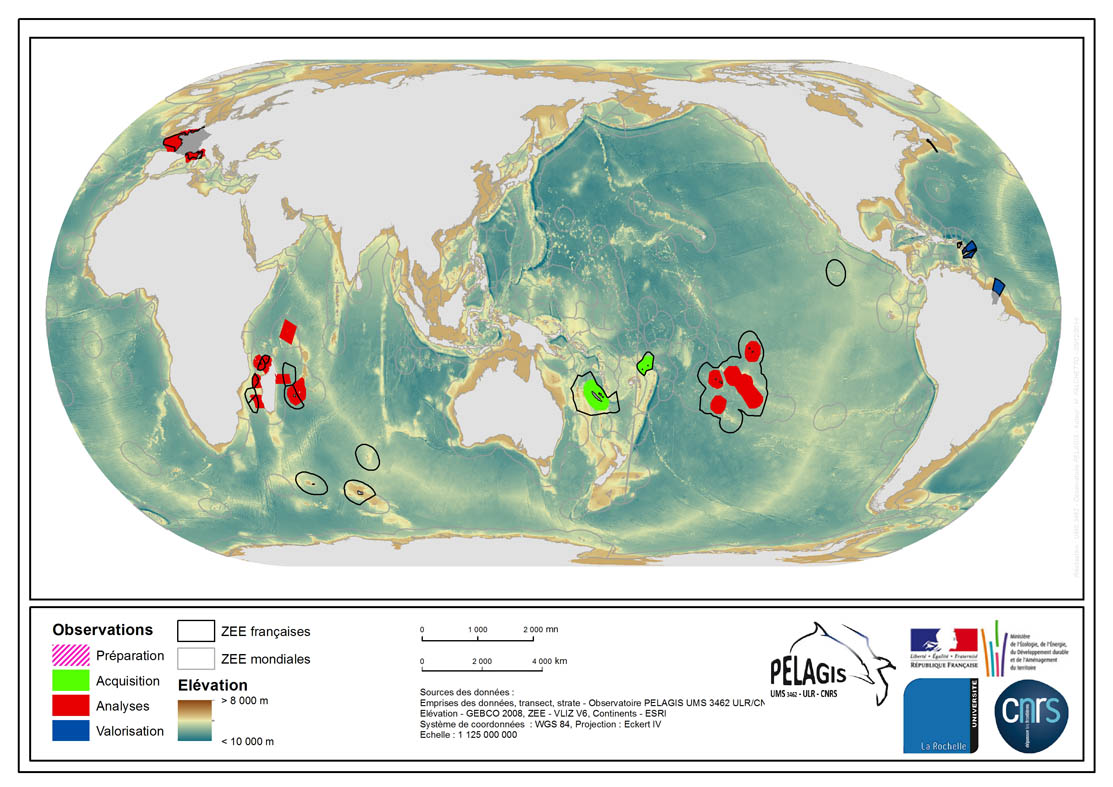
Visual Observations from Aerial Platforms- 1. Range
The associated data highlights the spatial influence of the dataset of the type “Visual Observations from an Aerial Platform” from the PELAGIS Observatory.
These ranges represent the different areas of study on which the PELAGIS observatory conducted campaigns of visual observations from aerial platforms.
Each area of study is associated with at least one campaign, with observers and geographical sectors linked to that campaign. Each sector is associated with bathymetric strips and transects related to each of the strips, with a few exceptions for the Indian Ocean region.
Description of fields and values of the attribute tables :
(- field name, meaning : value, description of values)
- region, area of study specific to the PELAGIS observatory PELAGIS : OI/FRM/ AGFR/SOP/SP, region_lbl
- programme, associated programme of which the campaign is a part: REMMOA/PACOMM, REcensement de la Mégafaune Marine par Observation Aérienne/Programme d'Acquisition sur les Oiseaux et Mammifères Marins
- idCampagne, abbreviated name of the data collection campaign: OI/SAMM/ ANT/SOP/PF/GUY, Campagne Océan Indien/Suivi Aérien de la Mégafaune Marine/Sud Ouest Pacifique/Polynésie Française/ Guyane française
- progress, current state of the campaigns, from collection to scientific optimisation : Preparation/Acquisition/ Analysis/Enhancement, campaign being prepared/under acquisition/being analysed/data enhanced within the context of a scientific publication.
Simple
- Alternate title
- PELAGIS_2013_1_EMPRISES_OVIPA
- Date ( Creation )
- 2013-03-07
- Identifier
- FR_19170032700015_2670_PELAGIS_2013_1_EMPRISES_OVIPA
+33(0)5 46 44 99 45
http://crmm.univ-lr.fr/
- Presentation form
- Digital map
- Purpose
-
To produce an inventory of the spatial distribution and abundance of these species and to assess their spatial and temporal variability in order to provide information for a common reflection on the designation and management of Marine Protected Areas.
General presentation of data of the type “Visual Observations from Aerial Platforms”: the datasets are created by marine flyovers which observe marine birds, marine mammals, other species of pelagic megafauna, and human activity (floating waste, vessels, etc.). This type of data is a collection of many types of datasets: REMMOA Antilles (2008), REMMOA French Guyana (2008), REMMOA OI (2009-2010), REMMOA PF (2011), SAMM1 (winter 2011) and SAMM2 (summer 2012).
- Credit
- PELAGIS observatory- UMS 3462 ULR/CNRS, marine protection agency
- Status
- Under development
- Maintenance and update frequency
- Irregular
- Maintenance note
- Mise à jour de la valeur d'avancement de l'id 2, passage de l'avancement "en cours d'acquisition" à "Analyse".
- Name
- ESRI Shapefile
- Version
- 0.1
- Keywords ( Stratum )
-
- Occurrence
- Presence
- Distribution
- Density
- Abundance
- Habitat
- Keywords ( Place )
-
- French West Indies
- French Guyana
- Indian Ocean Commission
- French Polynesia
- France
- New Caledonia
- Keywords ( Discipline )
-
- Natura 2000 en mer
- Protected Marine Area
- MSFD
- Pelagos
- Habitat directive
- Birds directive
- GEMET - INSPIRE themes, version 1.0 GEMET - INSPIRE themes, version 1.0 ( Theme )
-
- Species distribution
- Sous-regions marines Sous-regions marines ( Place )
-
- National
- Cadre Réglementaire - SIMM Cadre Réglementaire - SIMM ( Theme )
-
- Directive Cadre Stratégie pour le Milieu Marin (DCSMM)
- Directive Cadre pour la Planification de l'Espace Maritime (DCPEM)
- Directive Habitat, Faune et Flore
- Directive Oiseaux
- Directive Cadre sur les Déchets
- DCSMM : Descripteurs DCSMM : Descripteurs ( Theme )
-
- D10: Marine Litter
- D1: Biodiversité - Mammifères
- D1: Biodiversity
- D1: Birds, Marine Mammals and Turtles
- Thématiques - SIMM Thématiques - SIMM ( Theme )
-
- /Etat du Milieu/Espèces
- Type de jeux de donnée ODATIS Type de jeux de donnée ODATIS ( Theme )
-
- /in-situ observations/Sea cruises
- Specific usage
- For information only. The range of the aerial observation data only provides records of the progress of the data, from initial processing to scientific publication.
- Use limitation
- Non commercial use only and on the condition that the source is referenced (at least the name of the data producer) along with the date of the most recent update.
- Access constraints
- Intellectual property rights
- Use constraints
- Copyright
- Use constraints
- Other restrictions
- Other constraints
-
Mandatory citation "Observatoire PELAGIS, UMS 3462 ULR/
CNRS, AAMP, 'database name'"
Users must make contact with the data providers prior to all use, scientific publication and/or "coauthorship" if considered necessary by data owners
- Spatial representation type
- Vector
- Metadata language
- fr
- Character set
- UTF8
- Topic category
-
- Biota
- Environment description
- FME 2013+; Microsoft Windows 7 Version 6.1 (Build 7601) Service Pack 1; ESRI ArcGIS 10+, Access 2003, VOR
))
- Reference system identifier
- CRS:84
- Reference system identifier
- EPSG:4326
- Reference system identifier
- EPSG:27582
- Reference system identifier
- EPSG:3395
- Reference system identifier
- EPSG:2154
- Topology level
- Geometry only
- Geometric object type
- Complex
- Geometric object count
- 6
- Distribution format
-
-
(
)
-
(
)
- OnLine resource
- PELAGIS_OBSVI_PLATEFORME_AERIEN_EMPRISES_P ( OGC:WMS )
- Protocol
- FILE
- Name
- PELAGIS_OBSVI_PLATEFORME_AERIEN_EMPRISES_P
- Hierarchy level
- Dataset
- Statement
- Fusion of bathymetric strata for all aerial observation campaigns
- Included with dataset
- No
- Feature catalogue citation
- File identifier
- 339f6f3f-5fb0-4d4b-b819-b5d988e6aedd XML
- Metadata language
- fr
- Character set
- UTF8
- Hierarchy level
- Series
- Date stamp
- 2020-06-04T00:23:02
- Metadata standard name
- ISO 19115:2003/19139 - SEXTANT
- Metadata standard version
- 1.0
05 46 44 99 45
Overviews
Spatial extent
Provided by
