 Mon GéoSource
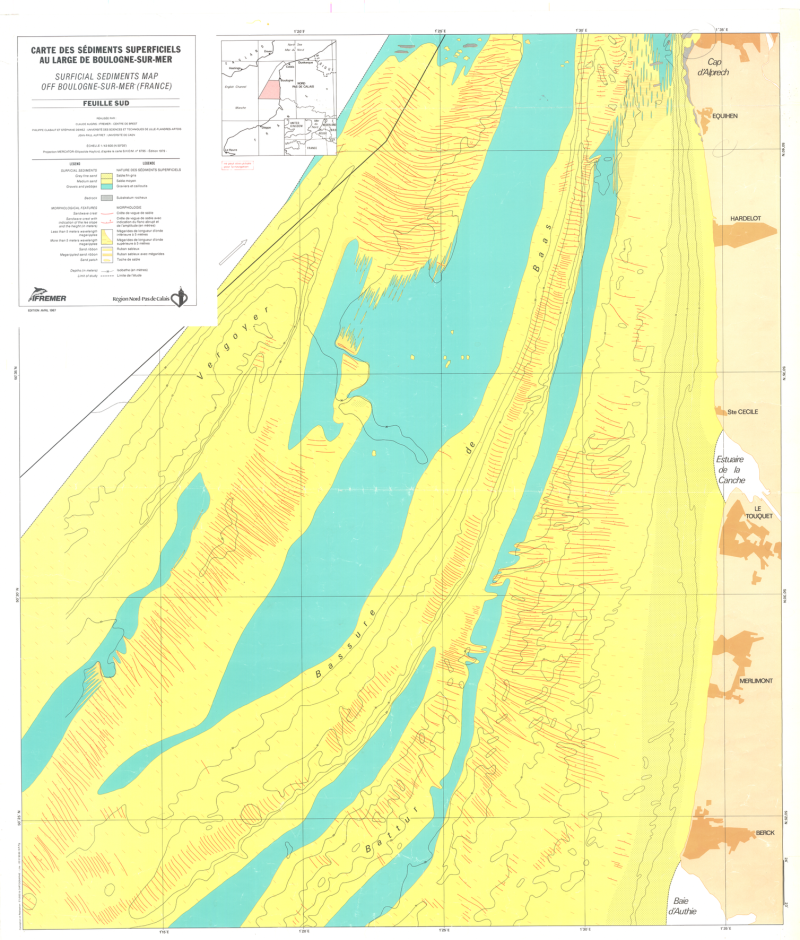
Carte des sédiments superficiels au large de Boulogne - sur - mer (scan géoréférencé)
Scan de la carte des sédiments superficiels au large de Boulogne-sur-mer (édition 1987 ; Echelle 1/43 400)
Simple
- Alternate title
- IFR_SED_BOULOGNE_1987_R
- Alternate title
- boulogne_georef = IFR_SED_BOULOGNE -> IFR_SED_BOULOGNE_1987_R
- Date ( Publication )
- 1987-01-01T00:00:00
- Date ( Creation )
- 2006-08-01T00:00:00
- Edition
- carte papier, édition Ifremer
- Edition date
- 1987-01-01T00:00:00
- Identifier
- FR-330-715-368-00032-IFR_SED_BOULOGNE_1987_R
- Presentation form
- Digital image
- Credit
- Ifremer, Géosciences Marines, 1987
- Status
- Completed
Author
Ifremer - Géosciences Marines
-
Claude Augris
(
Géologue
)
0298224570
BP 70
,
Plouzané
,
29280
,
France
0298224242
0298224570
Point of contact
Ifremer - Géosciences Marines
-
Catherine SATRA LE BRIS
(
Cartographe
)
BP 70
,
Plouzané
,
29280
,
France
0298224632
- Maintenance and update frequency
- Not planned
- Thèmes Sextant ( Theme )
-
- /Cartes scannées/Ifremer/Sédimentologie
- GEMET - INSPIRE themes, version 1.0 ( Theme )
-
- Géologie
- external.theme.gemet ( Theme )
-
- fond marin
- sédiment marin
- Keywords ( Theme )
-
- formations superficielles
- nature des fonds
- Keywords ( Place )
-
- Nord-Pas de Calais
- Boulogne-sur-mer
- Manche
- Keywords ( Discipline )
-
- géophysique
- sédimentologie
- Use limitation
- Utilisation interdite pour un usage commercial.
- Use limitation
- Modification et diffusion interdite de la donnée sans l'accord du distributeur.
- Access constraints
- Other restrictions
- Use constraints
- Copyright
- Other constraints
- Obligation de citation : AUGRIS C., CLABAUT P., DEWEZ S., AUFFRET J. P. (1987) - Carte des sédiments superficiels au large de Boulogne-sur-mer (Nord-Pas de Calais). Echelle 1/43 400. Ed. Ifremer - Région Nord-Pas de Calais.
- Spatial representation type
- Grid
- Denominator
- 40000
- Metadata language
- fr
- Character set
- UTF8
- Topic category
-
- Geoscientific information
- Description
- période d'acquisition des données
- Begin date
- 1983-07-03T00:00:00
- End date
- 1988-07-04T00:00:00
N
S
E
W
))
- Reference system identifier
- EPSG / ED50 (EPSG:4230) / 7.4
- Number of dimensions
- 2
- Dimension name
- Column
- Dimension size
- 2000
- Resolution
- 16.79097 m
- Dimension name
- Row
- Dimension size
- 2350
- Resolution
- 16.62772 m
- Cell geometry
- Area
- Transformation parameter availability
- No
- Distribution format
-
-
(
)
-
(
)
- OnLine resource
-
IFR_SED_BOULOGNE
(
OGC:WMS
)
Scan géoréférencé
- Hierarchy level
- Dataset
Conformance result
- Date ( Publication )
- 2007-03-14
- Explanation
- Non évalué
- Pass
- No
- Statement
- Carte originale papier
- Description
- Carte originale papier scannée
- File identifier
- 3e553d40-bc0b-11df-a9b6-005056987263 XML
- Metadata language
- fr
- Character set
- UTF8
- Parent identifier
- 683f9e80-bbec-11df-a9b6-005056987263 683f9e80-bbec-11df-a9b6-005056987263
- Hierarchy level
- Dataset
- Date stamp
- 2020-12-04T14:22:59
- Metadata standard name
- ISO 19115:2003/19139 - SEXTANT
- Metadata standard version
- 1.0
Point of contact
Ifremer - Géosciences Marines
-
Catherine Satra Le Bris
(
Cartographe
)
BP 70
,
Plouzané
,
29280
,
France
Overviews
Spatial extent
N
S
E
W
Provided by

Associated resources
Not available