 Mon GéoSource
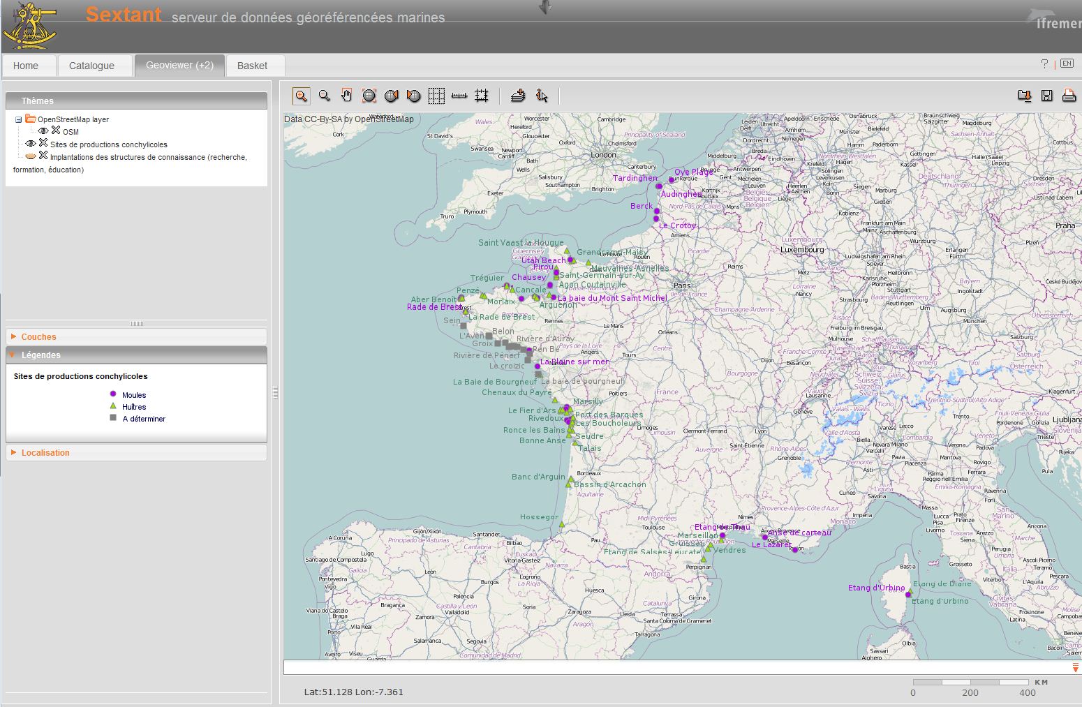
EUROSHELL - Shellfish production areas
Shellfish farming areas can have different meanings. Sometimes their identification is prescribed and used for health classification of production areas. In Euroshell project, the choice was made to map the production areas whose identification makes sense for both scientists and professionals. A limited number of areas is then showed, often corresponding to a hydrographic reality. Indeed, the shellfish industry is mainly installed in estuaries, river mouths, bays, fjords, estuaries or lagoons.
This map shows the shellfish production sites, which include several areas. Some information is given on species produced, the number of companies and / or concessions and / or producers, the approximate amount of production.
Simple
- Date ( Creation )
- 2013-01-18T00:00:00
- Identifier
- SITES_PRODUCTIONS_CONCHYLICOLES_P
- Credit
- Ifremer
- Status
- On going
- Maintenance and update frequency
- As needed
- Thèmes Sextant Thèmes Sextant ( Theme )
-
- /Human Activities/Marine cultures
- Keywords ( Theme )
-
- conchyliculture
- shellfish production area
- oysters, mussels, clams
- GEMET - INSPIRE themes, version 1.0 GEMET - INSPIRE themes, version 1.0 ( Theme )
-
- Installations agricoles et aquacoles
- Keywords ( Theme )
-
- Open Data
- Access constraints
- Copyright
- Access constraints
- Other restrictions
- Other constraints
- EUROSHELL
- Other constraints
- Partenaires du projet EUROSHELL
- Spatial representation type
- Vector
- Metadata language
- fr
- Character set
- UTF8
- Topic category
-
- Oceans
))
- Reference system identifier
- / 4326 /
- Reference system identifier
- EPSG / WGS 84 (EPSG:4326) / 7.9
- Topology level
- Geometry only
- Geometric object type
- Complex
- Geometric object count
- 69
- Distribution format
-
-
(
)
-
(
)
- OnLine resource
-
EUROSHELL_ZONES_PRODUCTION_FRANCE_PT
(
OGC:WMS
)
France
- OnLine resource
-
EUROSHELL_ZONES_PRODUCTION_FRANCE_PT
(
OGC:WFS
)
France
- OnLine resource
-
EUROSHELL_ZONES_PRODUCTION_IRLANDE_PT
(
OGC:WMS
)
Irlande
- OnLine resource
-
EUROSHELL_ZONES_PRODUCTION_IRLANDE_PT
(
OGC:WFS
)
Irlande
- OnLine resource
-
EUROSHELL_ZONES_PRODUCTION_ITALY_PT
(
OGC:WMS
)
Italy
- OnLine resource
-
EUROSHELL_ZONES_PRODUCTION_ITALY_PT
(
OGC:WFS
)
Italy
- OnLine resource
-
EUROSHELL_ZONES_PRODUCTION_NETHERLANDS_PT
(
OGC:WMS
)
Netherlands
- OnLine resource
-
EUROSHELL_ZONES_PRODUCTION_NETHERLANDS_PT
(
OGC:WFS
)
Netherlands
- OnLine resource
-
EUROSHELL_ZONES_PRODUCTION_UK_PT
(
OGC:WMS
)
UK
- OnLine resource
-
EUROSHELL_ZONES_PRODUCTION_UK_PT
(
OGC:WFS
)
UK
- Hierarchy level
- Dataset
Conformance result
- Date ( Creation )
- 2012-01-16
- Explanation
- Non évalué
- Pass
- No
- Statement
- The data were provided by the professional organisations of each country partner of Euroshell. These national partners have generated the data or used existing data.
- File identifier
- 4a7d3d79-edb8-45f5-b8ce-3b9bcd271b4f XML
- Metadata language
- fr
- Character set
- UTF8
- Hierarchy level
- Dataset
- Date stamp
- 2020-06-04T00:36:57
- Metadata standard name
- ISO 19115:2003/19139 - SEXTANT
- Metadata standard version
- 1.0
Overviews
Spatial extent
Provided by
