 Mon GéoSource
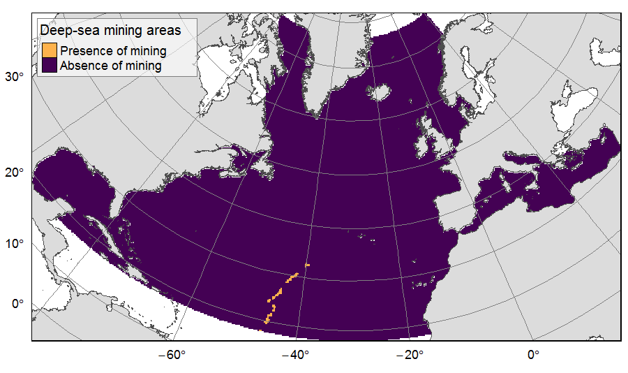
Deep-sea mining activities on the North Atlantic
Presence of deep-sea mining exploration zones on the North Atlantic (18°N to 76°N and 36°E to 98°W). These areas correspond to the three polymetallic sulphides exploration contracts on the Mid-Atlantic Ridge, attributed to Poland, France and Russia. Each of the three contract areas is divided into 100 squares of 10km by 10km. Source polygons originated from the International Seabed Authority. The presence (value=1) of deep-sea mining was extracted in 25km * 25km gridsquares.
This dataset was built to feed a basin-wide spatial conservation planning exercise, targeting the deep sea of the North Atlantic. The goal of this approach was to identify conservation priority areas for Vulnerable Marine Ecosystems (VMEs) and deep fish species, based on the distribution of species and habitats, human activities and current spatial management.
Simple
- Date ( Publication )
- 2019-08-14
- Identifier
- FR-330-715-368-00032-IFR_MARBEC_ATLAS_Mining
- Identifier
- DOI:10.12770/4ab2fb42-ba5b-418d-9675-a642edfaca70
- Credit
- Horizon 2020 ATLAS project (EU)
- Thèmes Sextant ( Theme )
-
- /Human Activities/Various
- GEMET - INSPIRE themes, version 1.0 ( Theme )
-
- Mineral resources
- Use limitation
- CC-BY-NC-SA (Creative Commons - Attribution, Pas d’utilisation commerciale, Partage dans les mêmes conditions)
- Access constraints
- License
- Use constraints
- License
- Spatial representation type
- Grid
- Distance
- 25 km
- Metadata language
- en
- Character set
- UTF8
- Topic category
-
- Oceans
- Environment
))
- Reference system identifier
- +proj=aea +lat_1=43 +lat_2=62 +lat_0=30 +lon_0=-30 +x_0=0 +y_0=0 +datum=WGS84 +units=m +no_defs +ellps=WGS84 +towgs84=0,0,0
- Number of dimensions
- 2
- Dimension name
- Row
- Dimension size
- 273
- Resolution
- 25 km
- Dimension name
- Column
- Dimension size
- 491
- Resolution
- 25 km
- Cell geometry
- surface
- Transformation parameter availability
- No
- OnLine resource
-
IFR_MARBEC_ATLAS_MINING_NORTHATL
(
OGC:WMS
)
Deep-sea mining exploration - North Atlantic
- Protocol
- COPYFILE
- Name
- IFR_MARBEC_ATLAS_MINING_NORTHATL
- Description
- Deep-sea mining exploration - North Atlantic
- OnLine resource
- International Seabed Authority (2019) Polymetallic Sulphides/Mid Atlantic Ridge. https://www.isa.org.jm/maps ( WWW:LINK )
- OnLine resource
-
DOI of the dataset
(
WWW:LINK-1.0-http--metadata-URL
)
DOI of the dataset
- Hierarchy level
- Dataset
Conformance result
- Date ( Publication )
- 2010-12-08
- Explanation
- See the referenced specification
- Statement
- Source polygons data originated from the International Seabed Authority (ISA). The data was extracted in 25km * 25 km gridsquares of the raster grid used for the ATLAS spatial prioritization. Source data reference: International Seabed Authority (2019). Polymetallic Sulphides/Mid Atlantic Ridge. https://www.isa.org.jm/maps
- Description
- ISA attributed three polymetallic sulphides exploration contracts on the Mid-Atlantic Ridge, to Poland (2018 to 2033), France (2014 to 2029) and Russia (2012 to 2027) (https://www.isa.org.jm/maps). Each of the three contract areas is divided into 100 squares of 10km by 10km.
- Rationale
- Initial dataset
- Description
- Using the R environment, the rasterize function was used to extract the presence mining in 25km *25km gridsquares. Values of output raster cells where no exploration contracts were present were set to 0, while values of cells out of the study zone were set to NA. The Russian contract had 68 exploration squares located south of the study zone, thus only 232 squares out of 300 are included.
- Rationale
- extraction of features on the ATLAS grid
- File identifier
- 4ab2fb42-ba5b-418d-9675-a642edfaca70 XML
- Metadata language
- en
- Character set
- UTF8
- Hierarchy level
- Dataset
- Date stamp
- 2020-02-20T14:23:30
- Metadata standard name
- ISO 19115:2003/19139 - SEXTANT
- Metadata standard version
- 1.0
Overviews
Spatial extent
Provided by
