 Mon GéoSource
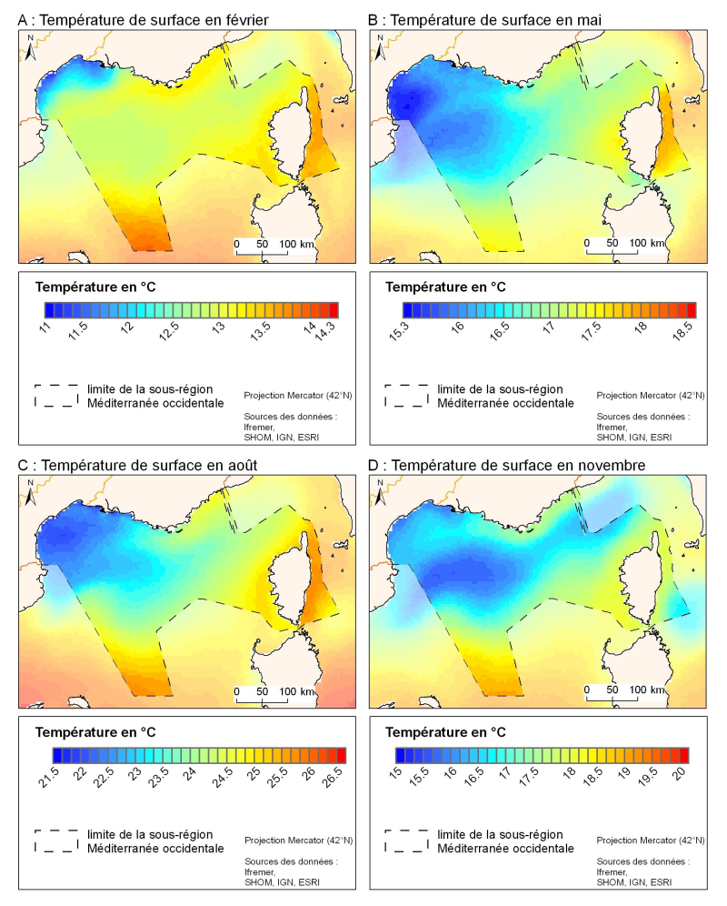
Monthly climatology of surface temperature from satellite images
Simple
- Date ( Publication )
- 2001-11-01
- Identifier
- month-EUR-L4UHRfnd-IBIROOS-v01-fv01-OIAVHRR
- Credit
- Ifremer, MEDAR/MEDATLAS
02 98 22 48 64
- Thèmes Sextant Thèmes Sextant ( Theme )
-
- /Physical Environment/Climatology
- Keywords ( Theme )
-
- spatio-temporal distribution ; surface temperature ; satellite imagery
- Keywords ( Discipline )
-
- Climatology
- GEMET - INSPIRE themes, version 1.0 GEMET - INSPIRE themes, version 1.0 ( Theme )
-
- Oceanographic geographical features
- Keywords ( Place )
-
- Mediterranean Sea
- Sous-regions marines Sous-regions marines ( Place )
-
- Western Mediterranean
- Access constraints
- Copyright
- Use constraints
- Copyright
- Other constraints
- free access, all public
- Classification
- Unclassified
- Spatial representation type
- Grid
- Metadata language
- fr
- Character set
- UTF8
- Topic category
-
- Climatology, meteorology, atmosphere
- Oceans
))
- Reference system identifier
- EPSG / WGS84 géographiques / 7.4
- Distribution format
-
-
Netcdf
(
)
-
Netcdf
(
)
- OnLine resource
- site web du projet Medatlas/Medar ( WWW:LINK )
- OnLine resource
- site web du projet Medatlas/Medar ( WWW:LINK )
- OnLine resource
- site internet Ifremer dédié à la Directive Cadre Stratégie pour le Milieu Marin ( WWW:LINK )
- OnLine resource
-
carthothèque DCSMM
(
WWW:LINK
)
System of temperature and salinity
- Hierarchy level
- Dataset
- Statement
-
Yannice Faugère, Pierre Le Borgne and Hervé Roquet (2001) Construction of a global fine scale climatology of sea surface temperatures. Meteorology No. 35 November 2001.
http://hdl.handle.net/2042/35926.
MEDAR / MEDATLAS Climatomogy. http://modb.oce.ulg.ac.be/backup/medar/medar.html
- File identifier
- 58d91bed-ee7d-4368-84bf-920b5e9de77c XML
- Metadata language
- fr
- Character set
- UTF8
- Hierarchy level
- Series
- Hierarchy level name
- Ensemble de jeux de données
- Date stamp
- 2020-06-04T00:22:30
- Metadata standard name
- ISO 19115:2003/19139 - SEXTANT
- Metadata standard version
- 1.0
Overviews
Spatial extent
Provided by
