 Mon GéoSource
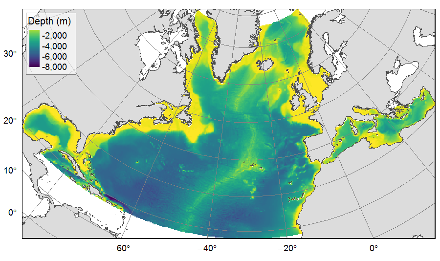
Deep-sea bathymetric variables (slope, depth, BPI) on the North Atlantic
Distribution of three bathymetric terrain variables (depth, slope and Bathymetric Position Index) on the North Atlantic (18°N to 76°N and 36°E to 98°W). This dataset originated from three source layers (3km * 3km resolution) computed within the work package 3 of EU ATLAS project, and based on the EMODnet Digital Bathymetry portal and the General Bathymetric Chart of the Oceans (GEBCO). From these source layers, the mean depth (m), slope (degree) and BPI (no unit) were calculated for each 25km * 25km gridsquare.
This dataset was built to feed a basin-wide spatial conservation planning exercise, targeting the deep sea of the North Atlantic. The goal of this approach was to identify conservation priority areas for Vulnerable Marine Ecosystems (VMEs) and deep fish species, based on the distribution of species and habitats, human activities and current spatial management.
Simple
- Date ( Publication )
- 2019-08-14
- Identifier
- FR-330-715-368-00032-IFR_MARBEC_ATLAS_Bath_Var
- Identifier
- DOI:10.12770/7134e787-416e-4876-b84b-1ac65ca21f0d
- Credit
- Horizon 2020 ATLAS project (EU)
- Thèmes Sextant ( Theme )
-
- /Physical Environment/Bathymetry/Digital Terrain Model
- GEMET - INSPIRE themes, version 1.0 ( Theme )
-
- Elevation
- Use limitation
- CC-BY-NC-SA (Creative Commons - Attribution, Pas d’utilisation commerciale, Partage dans les mêmes conditions)
- Access constraints
- License
- Use constraints
- License
- Spatial representation type
- Grid
- Distance
- 25 km
- Metadata language
- en
- Character set
- UTF8
- Topic category
-
- Oceans
))
- Reference system identifier
- +proj=aea +lat_1=43 +lat_2=62 +lat_0=30 +lon_0=-30 +x_0=0 +y_0=0 +datum=WGS84 +units=m +no_defs +ellps=WGS84 +towgs84=0,0,0
- Number of dimensions
- 2
- Dimension name
- Row
- Dimension size
- 273
- Resolution
- 25 km
- Dimension name
- Column
- Dimension size
- 491
- Resolution
- 25 km
- Cell geometry
- surface
- Transformation parameter availability
- No
- OnLine resource
-
IFR_MARBEC_ATLAS_MEAN_BPI_NORTHATL
(
OGC:WMS
)
Mean Bathymetric Position Index - North Atlantic
- Protocol
- COPYFILE
- Name
- IFR_MARBEC_ATLAS_MEAN_BPI_NORTHATL
- Description
- Mean Bathymetric Position Index - North Atlantic
- OnLine resource
-
Morato, T, González‐Irusta, J‐M, Dominguez‐Carrió, C, et al., 2020
(
WWW:LINK-1.0-http--publication-URL
)
Morato, T, González‐Irusta, J‐M, Dominguez‐Carrió, C, et al. Climate‐induced changes in the suitable habitat of cold‐water corals and commercially important deep‐sea fishes in the North Atlantic. Glob Change Biol. 2020; 26: 2181– 2202. https://doi.org/10.1111/gcb.14996
- OnLine resource
-
IFR_MARBEC_ATLAS_MEAN_DEPTH_NORTHATL
(
OGC:WMS
)
Mean depth - North Atlantic
- Protocol
- COPYFILE
- Name
- IFR_MARBEC_ATLAS_MEAN_DEPTH_NORTHATL
- Description
- Mean depth - North Atlantic
- OnLine resource
-
IFR_MARBEC_ATLAS_MEAN_SLOPE_NORTHATL
(
OGC:WMS
)
Mean slope - north Atlantic
- Protocol
- COPYFILE
- Name
- IFR_MARBEC_ATLAS_MEAN_SLOPE_NORTHATL
- Description
- Mean slope - north Atlantic
- OnLine resource
-
DOI of the dataset
(
WWW:LINK-1.0-http--metadata-URL
)
DOI of the dataset
- Hierarchy level
- Dataset
Conformance result
- Date ( Publication )
- 2010-12-08
- Explanation
- See the referenced specification
- Statement
-
The three terrain variables were initially computed for the ATLAS Deliverable 3.3 by IMAR (Instituto do Mar, Universidade dos Açores, Horta, Portugal). The values of initial layers of 3km * 3km resolution were averaged in 25km * 25 km gridsquares of the raster grid used for the ATLAS spatial prioritization.
Source data reference:
Morato, T, González‐Irusta, J‐M, Dominguez‐Carrió, C, et al. Climate‐induced changes in the suitable habitat of cold‐water corals and commercially important deep‐sea fishes in the North Atlantic. Glob Change Biol. 2020; 26: 2181– 2202. https://doi.org/10.1111/gcb.14996
Telmo Morato, José-Manuel González-Irusta, Carlos Dominguez-Carrió, Chih-Lin Wei, Andrew Davies, Andrew K. Sweetman, Gerald H. Taranto, Lindsay Beazley, Ana García-Alegre, Anthony Grehan, Pascal Laffargue, F. Javier Murillo, Mar Sacau, Sandrine Vaz, Ellen Kenchington, Sophie Arnaud-Haond, Oisin Callery, Giovanni Chimienti, Erik Cordes, Hronn Egilsdottir, André Freiwald, Ryan Gasbarro, Matt Gianni; Kent Gilkinson, Vonda E. Wareham Hayes, Dierk Hebbeln, Kevin Hedges, Lea-Anne Henry, Georgios Kazanidis, Mariano Koen-Alonso, Cam Lirette, Francesco Mastrototaro, Lénaick Menot, Tina Molodtsova, Pablo Durán Muñoz, Bramley Murton, Covadonga Orejas, Maria Grazia Pennino, Patricia Puerta, Stefán Á. Ragnarsson, Berta Ramiro-Sánchez, Jake Rice, Jesús Rivera, Murray Roberts, Luís Rodrigues,
Steve W. Ross, José L. Rueda, Tim Siferd, Paul Snelgrove, David Stirling, Margaret Treble, Javier Urra, Johanne Vad, Les Watling, Wojciech Walkusz, Zeliang Wang, Claudia Wienberg, Mathieu Woillez, Lisa A. Levin, Francis Neat, Diya Das, Laurence Fauconnet, Claudia Viegas, Pedro Afonso, Gui Menezes, Mario Rui Pinho, Helder Silva, Alexandra Rosa, Diana Catarino, Eva Giacomello, Javi Guijarro, Jason Cleland, Isobel Yeo, Joana R. Xavier, Íris Sampaio, Jeremy Spearman, Lissette Victorero, Charles G. Messing, Meri Bilan, Jordi Blasco-Ferre, Jean-François Bourillet, Laurent de Chambure, Jaime S. Davies, Norbert Frank, Brigitte Guillaumont, Konstantinos Georgoulas, Barbara Berx, Karine Olu, Manuela Ramos, Laís Ramalho, Olga Reñones, José Antonio Caballero, Fernando Tempera, Julie Tourolle, Olga Utrilla, Inge van den Beld, Olga Utrilla, Igor Yashayaev, Marina Carreiro-Silva (2019) ATLAS EU D3.3 Biodiversity, biogeography and GOODS classification system under current climate conditions and future IPCC scenarios. https://www.eu-atlas.org/resources/atlas-library
- Description
-
Terrain variable depth (in m) was extracted from a bathymetry grid built from two data sources: the EMODnet Digital Bathymetry portal (EMODnet, 2016) and the General Bathymetric Chart of the Oceans (GEBCO, 2014). The original resolution from EMODnet (0.002°) was up-scaled to the GEBCO resolution (0.008°) using a bilinear interpolation. The bathymetry layers were merged by using EMODnet data when available and completing it with GEBCO 2014, and rescaled to the final resolution of 3x3 km using bilinear interpolation. Slope (in degrees) was derived from the final bathymetry grid using the package raster of the R environment and the Bathymetric Position Index (BPI) was computed using the Benthic Terrain Model 3.0 tool in ArcGIS 10.1 with an inner radius of 3 and an outer radius of 25. In order to avoid extreme values, BPI was standardized using the scale function from the raster package.
References: EMODnet Bathymetry Consortium. (2016). EMODnet Digital Bathymetry (DTM 2016) [Data set]. https://doi.org/10.12770/c7b53704-999d-4721-b1a3-04ec60c87238 ; GEBCO (2014) .General Bathymetric Chart of the Oceans - GEBCO_2014 Grid. https://www.gebco.net/data_and_products/historical_data_sets/#gebco_2014
- Rationale
- Computation of depth, slope and BPI
- Description
- Using the R environment, the ATLAS spatial prioritization raster grid of 25km * 25km resolution was transformed to polygons, each polygon representing a gridsquare in the study area. Mean values of depth, slope and BPI were calculated for each gridsquare using the extract function from the velox package in R, allowing to account for the area of each raster cell overlapping with the gridsquare. Polygon gridsquare were transformed back to raster using the rasterize function from the velox package.
- Rationale
- extraction of variables on the ATLAS grid
- File identifier
- 7134e787-416e-4876-b84b-1ac65ca21f0d XML
- Metadata language
- en
- Character set
- UTF8
- Hierarchy level
- Dataset
- Date stamp
- 2020-03-16T18:50:26
- Metadata standard name
- ISO 19115:2003/19139 - SEXTANT
- Metadata standard version
- 1.0
Overviews
Spatial extent
Provided by
