 Mon GéoSource
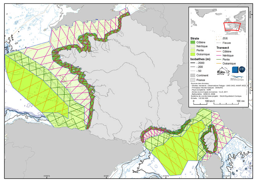
Visual Observations on the Dedicated Aerial Platform - 2. Sampling Programme- PACOMM/SAMM1 and SAMM2
The associated data highlights the sampling programme for the data acquisition campaign of Observation on the Aerial Platform for the SAMM1and SAMM2 campaigns (Aerial Marine Megafauna Monitoring) conducted by the PELAGIS observatory (UMS 3462 ULR/CNRS).
The sampling plan is composed of preestablished sampling strata and transects. These were drawn up according to the specific characteristic of the study area “Mainland France”, or FrM.
Description of fields and values of allocation tables:
: ( - field name, meaning: value, description of values) region char 5 Study area
region_lbl char 50 labelled study area
idCampagne (survey) char 15 Name of the campaign programme
char 20 Programme name
sector char 10 Sampling sector short ID
strate char 5 Sampling strata short ID
strate_lbl char 15 Labelled sampling strata
areaKM double Strata surface area
transect_name char 10 transect sampling
length_km double Transect length
start_x double Coordinates of the start of transect x in decimal degree
start_y double Coordinates of the start of transect y in decimal degree
end_x double Coordinates of the end of transect x in decimal degree
end_y double Coordinates of the end of transect y in decimal degree
Simple
- Alternate title
- PELAGIS_2013_2_ECHANTI_OVIPA_SAMM
- Date ( Creation )
- 2013-03-07
- Identifier
- FR_19170032700015_2670_PELAGIS_2013_2_ECHANTI_OVIPA_SAMM
05 46 44 99 45
www.observatoire-pelagis.cnrs.fr
- Presentation form
- Digital map
- Purpose
- To produce an inventory of spatial distribution and abundance of these species and to evaluate their spatial and temporal variability in order to provide information for common reflection on the identification and management of Marine Conservation Areas.
- Credit
- PELAGIS Observation- UMS 3462 ULR/CNRS, Marine Conservation Agency
- Status
- Under development
- Maintenance and update frequency
- As needed
- Name
- ESRI Shapefile
- Version
- 0.1
- Keywords ( Theme )
-
- Sampling
- Observation
- samm
- samm1
- Transect
- Strata
- Keywords ( Place )
-
- France
- Mainland
- Channel
- Atlantic
- Bay of Biscay
- Mediterranean
- Keywords ( Discipline )
-
- Natura 2000 en mer
- MSFD
- Pelagos
- Habitat directive
- Bird directive
- GEMET - INSPIRE themes, version 1.0 GEMET - INSPIRE themes, version 1.0 ( Theme )
-
- Species distribution
- Cadre Réglementaire - SIMM Cadre Réglementaire - SIMM ( Theme )
-
- Directive Cadre pour la Planification de l'Espace Maritime (DCPEM)
- Directive Cadre Stratégie pour le Milieu Marin (DCSMM)
- Directive Habitat, Faune et Flore
- Directive Oiseaux
- Directive Cadre sur les Déchets
- Type de jeux de donnée ODATIS Type de jeux de donnée ODATIS ( Theme )
-
- /in-situ observations/Sea cruises
- Thématiques - SIMM Thématiques - SIMM ( Theme )
-
- /Etat du Milieu/Espèces
- DCSMM : Descripteurs DCSMM : Descripteurs ( Theme )
-
- D1: Biodiversité - Mammifères
- D1: Biodiversity
- D1: Birds, Marine Mammals and Turtles
- D10: Marine Litter
- Sous-regions marines Sous-regions marines ( Place )
-
- /Métropole
- Bay of Biscay
- Channel-North Sea
- Western Mediterranean
- Celtic Seas
- Use limitation
- Non commercial use only on the condition that the source is cited in all publications (citing at least the name of the producer) along with the date of the latest update.
- Use limitation
- The sampling programme was specifically designed to meet the objectives of the SAMM campaign within the context of the PACOMM programme. Reusing just part of this data is meaniningless.
- Access constraints
- Intellectual property rights
- Use constraints
- Copyright
- Use constraints
- Other restrictions
- Other constraints
-
Mandatory citation "Observatoire PELAGIS, UMS 3462 ULR/
CNRS, AAMP, CEBC, 'database name'"
Users must make contact with the data providers prior to all use, scientific publication and/or "coauthorship" if considered necessary by the owners of the data.
- Spatial representation type
- Vector
- Denominator
- 100000
- Metadata language
- fr
- Character set
- UTF8
- Topic category
-
- Biota
- Oceans
- Environment description
- FME 2013+, Arcgis 10+, Access 2003, VOR, Windows 7
))
- Begin date
- 2011-12-01T00:00:00
- End date
- 2012-01-29T00:00:00
- Reference system identifier
- 4326
- Topology level
- Geometry only
- Geometric object type
- Complex
- Geometric object count
- 6
- Distribution format
-
-
ESRI Shapefile
(
1.0
)
-
ESRI Shapefile
(
1.0
)
- OnLine resource
-
PELAGIS_ECHANTI_OVIPA_SAMM1_A
(
OGC:WMS
)
Plan d'échantillonnage (Transects)
- Protocol
- FILE
- Name
- PELAGIS_ECHANTI_OVIPA_SAMM1_A
- Description
- Plan d'échantillonnage (Transects)
- OnLine resource
-
PELAGIS_ECHANTI_OVIPA_SAMM1_P
(
OGC:WMS
)
Plan d'échantillonnage (Strates)
- Protocol
- FILE
- Name
- PELAGIS_ECHANTI_OVIPA_SAMM1_P
- Description
- Plan d'échantillonnage (Strates)
- Hierarchy level
- Dataset
- Statement
-
- Data taken from the following collection and validation protocol : Methodological guide to observing marine mammals and birds in the France’s mainland coastal waters and adjacent areas – PACOMM – SAMM Programme . G.Dorémus et al. 2011.
- The acquisition protocol for this data on these campaigns was implemented thanks to the experience of the team from the PELAGIS observatory gathered over more than 10 years in the field, and notable through the aerial observation campaigns ROMER( 2000-2002), ATLANCET (2003) and SCANS (2005)
Observations are made from an aeroplane flying over predefined transects at a constant altitude of 600 feet and a speed of 90 knots. Two observers record the environmental conditions and the following observations (at the surface or below the surface):
- Using the strip transect method (200m strips): bird observations
- Using the line transect methods (up to 500m): observations of matine mammals, sharks, rays, bony fish (large fish or shoals of fish) and sea turtles.
- Using the strip transect method: macro waste (200 m strips) and boats (500m strips)
Data is collected and coordinated by the PELAGIS observatory by scientific teams and observers, all of whom are specifically trained in aerial observation protocol (identical protocols for REMMOA and SAMM).
Balance sheet :
SAMM campaigns have made it possible to collect over 20,000 pieces of data of the same type in France’s mainland waters along over 100,000 km of transects.
REMMOA campaigns have made it possible to collect over 58,000 observations of marine megafauna and human activity (waste, vessels and fishing gear) over nearly 205,000 km of transects travelled by plane over the sea.
- flyovers in mainland France – SAMM campaign (Aerial Marine Megafauna Monitoring) – are conducted in the context of the PACOMM programme in order to meet community objectives for conservation and the promotion of maritime areas (Natura 2000, MSFD, regional maritime conventions, etc.).
The dataset is made up of two datasets: samm1 for winter 2011 and samm2 for summer 2012.
Data collected within the framework of scientific research for the implementation of the Natura 2000 network at sea. The operational phase was conducted jointly by UMS 3462 for scientific coordination and by the Marine Protection Agency for the overall coordination of the project.
- Flyovers conducted in overseas territories – REMMOA programme (Monitoring of marine mammals and other pelagic megafauna by aerial observation), made up of four diversity and density mapping campaigns for pelagic megafauna in the EZE of French overseas territories (West Indies, French Guyana, Indian Ocean commission area, French Polynesia and New Caledonia) – aim to add to scientific knowledge (which is abundant and diverse in coastal areas) in the vast swathes of open ocean which make up the majority of French EZE in tropical areas of the Atlantic, Indian and Pacific oceans in order to identify the priority sectors for establishing news Marine Protection Areas and to draw up management programmes.
- Description
-
At least one campaign is attributed to each region of study.
Observers are attributed a campaign and a geographical area. For each sector there are bathymetric strata and transects which are linked to each of these strata (with a few exceptions for the Indian Ocean).
- Definition of sectors: zones corresponding to distinct maritime areas (seaboard, coast, archipelago, etc.)
- Definition of bathymetric strata : areas at the heart of each sector, determined according to bathymetric characteristics such as depth, relief and slope gradient.
- Definition of transects : breakdown of the observation effort between the bathymetric strata was defined according to expected observation rate (available in the literature or from previous unpublished campaigns) in order to obtain a significant number of observations for cetaceans and to make it possible to modify the effort during the campaign according to the real observation rate (increase or decrease of effort. The transects are distributed systematically within the strata.
- Bathymetric strata were divided by the European coastline
- Rationale
- SAMPLING PROGRAMME
- Description
-
Data was acquired during the flights and is also recorded digitally.
Back on land, the data is checked and errors removed. Corresponding codes for species, name, family and genus were verified using the TAXREFv5.0 reference. If need be, species identification is refined using photos taken during the flyovers. Data remains in the initial system of coordinates. Data is acquired within the context of a protocol defined as of acquisition (observers trained) for technical and scientific validation overseen by the PELAGIS observatory.
- Rationale
- ACQUISITION
- Description
-
On returning from the campaign, the data is subject to technical and scientific checks and revalidation but the experts and the PELAGIS observatory.
The effort is then adjusted and accounted for in order to determine the distribution rate (number of observations/km covered in the effort) Occurrence data is generated and transferred to the INPN and made available on Sextant for data managers and public policy makers.
Data is currently stored in its original format (VOR - Access)and as a Géodatabase file.
- Rationale
- POST-PROCESSING
- Description
-
Data is subject to automated FME 2013+ quality control.
This is the first level of data, that is to say when it is validated, adjusted and linked to the observations.
- Rationale
- QUALITY CONTROL
- Description
-
Data is prepared for analysis (labelled effort divided into equal segments, etc.)
Analyses are conducted using R and Distance.
This is the second level of data, that is to say the advanced level. this data format is not made public
- Rationale
- ANALYSES
- Included with dataset
- No
- Feature catalogue citation
- File identifier
- 911f6ce2-3406-4bdd-b616-c73725b66108 XML
- Metadata language
- fr
- Character set
- UTF8
- Parent identifier
- 9efd49a8-e85c-4393-988d-035a86b58977 9efd49a8-e85c-4393-988d-035a86b58977
- Hierarchy level
- Series
- Date stamp
- 2020-06-04T00:24:02
- Metadata standard name
- ISO 19115:2003/19139 - SEXTANT
- Metadata standard version
- 1.0
05 46 44 99 45
Overviews
Spatial extent
Provided by
