 Mon GéoSource
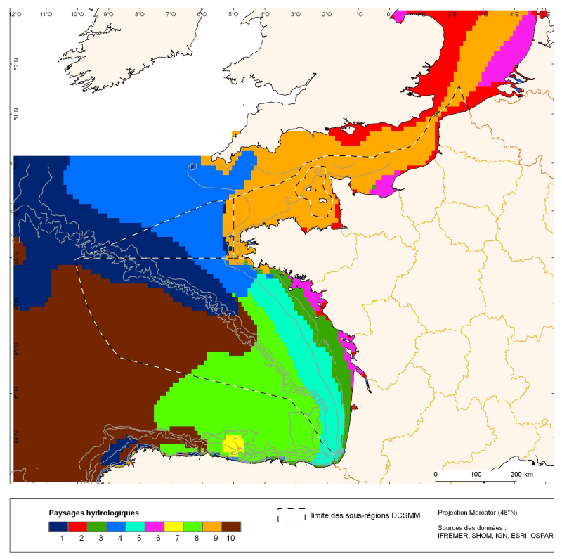
Distribution of hydrological landscapes with a similar annual variability identified in the English Channel and the Bay of Biscay
The distribution of hydrological landscapes is determined by a method of comparing multi-tables, to identify groups of individuals with similar variability of hydrological conditions during the year.
The data used provides monthly tables showing the selected parameters, calculated over the entire geographic area with a resolution of 0.1 °. The variable chlorophyll-a is extra: it does not contribute to the discrimination of groups. This method identifies 10 hydrological landscapes with a similar annual variability of hydrological conditions.
Simple
- Date ( Creation )
- 2011-07-01
- Identifier
- IFR_Paysages_hydro_Manche_Gascogne
- Credit
- Ifremer
- Thèmes Sextant Thèmes Sextant ( Theme )
-
- /Biological Environment/Habitats
- GEMET - INSPIRE themes, version 1.0 GEMET - INSPIRE themes, version 1.0 ( Theme )
-
- Oceanographic geographical features
- Keywords ( Theme )
-
- hydrological landscapes ; pelagic habitats
- Sous-regions marines Sous-regions marines ( Place )
-
- Bay of Biscay
- Channel-North Sea
- Celtic Seas
- Access constraints
- Intellectual property rights
- Use constraints
- Intellectual property rights
- Classification
- Unclassified
- Spatial representation type
- Grid
- Distance
- 0.1 degrès
- Metadata language
- fr
- Character set
- UTF8
- Topic category
-
- Geoscientific information
- Oceans
))
- Supplemental Information
-
Grp 1
Wide area (beyond 100m), was strongly influenced by desalinated plumes, not stratified, only present in winter and early spring. This area is also observed in November on the slope, where the breakdown of stratification is the fastest, with cold bottom temperatures and low phytoplankton production on the surface.
Grp 2
Offshore waters in May, early stratification with the presence of spring bloom.
Grp 3
Area of intermediate stratification through late spring, with a thermocline still relatively shallow and moderate. This area also includes offshore areas as well as the slope to the north and the upwelling of Galicia in the south, two areas that retain these features of limited stratification throughout the summer, due to internal waves in the first case, and of the wind causing upwelling in the second. These phenomena explain the constant higher production than Group 4 which was very reduced in the summer .
Grp 4
Offshore waters in the middle of summer, with a strong stratification, a sharp thermocline and relatively deep, and lack of phytoplankton production. This situation continues until October for some offshore areas.
Grp 5
Offshore waters to which the stratification decreases from October to November.
Grp 6
Middle shelf area in the southern Bay of Biscay, as well as beginning of the Channel with the stratification highest in the middle of summer, due to a significant warming and a relatively desalinated water surface compared to the broad groups described above.
Grp 7
Coastal strip, relatively desalinated, unstratified, present from May-June in areas under the influence of tidal mixing (northern Bay of Biscay and English Channel), and fairly warm throughout the water column as it is under the influence of surface warming.
Grp 8
Coastal strip between 50m and 100m isobaths, low desalination, with solids concentrations due to the substantial contribution by the plumes and re-suspension in the winter, unstratified, present on the northern area until May, before seasonal warming.
Grp 9
Plumes in the winter and early spring, with desalinated water, rich solids and temperatures below 10° C.
Grp 10
Plumes the rest of the year (summer-autumn), with higher temperatures and relatively less turbid waters.
- Reference system identifier
- EPSG / WGS84 géographiques / 7.4
- Distribution format
-
-
Esri shapes
(
ArcGIS 9.3.1
)
-
Esri shapes
(
ArcGIS 9.3.1
)
- OnLine resource
- site internet Ifremer dédié à la Directive Cadre Stratégie pour le Milieu Marin ( WWW:LINK )
- OnLine resource
-
carthothèque DCSMM
(
WWW:LINK
)
Distribution of primary biotopes in the main water column (pelagic)
- Hierarchy level
- Dataset
- Statement
-
Methodology for identifying hydrologic landscapes:
Besides temperature, which plays a direct role in the primary production and the entire ocean food web, other features such as stratification of the water column or salinity, reflecting the influence of plumes, have a major impact on the distribution of pelagic communities.
Hydrodynamic indices selected in this study are the following:
1) Indices of water column stratification:
- Lack of potential energy (PhiT, kg.m-1.s-2): energy required to homogenize (temperature, salinity or density) of the water column,
- Maximum vertical gradient in temperature (GradTmax, °C.m-1) or density (kg.m-3.m-1),
- Depth of the mixed layer (thermocline, pycnocline or halocline) (Zm, m),
2) Index "river plumes" surface salinity (SS)
3) Bottom temperature (BT, °C)
Hydrological indices are calculated according to the proposed formulas (Huret M., Struski C, Léger F, Petitgas P., Lazure P. and Sourisseau M. (2009). Coupled physical/biogeochemical modelling of the Golf of Biscay for the period 1971-2007 . R.INT.DOP / EMH / 2009-01). For the bottom temperature, a depth limit of 200 meters has been set. For other indices (deficit of potential energy, maximum vertical gradient temperature and depth of the mixed layer), a threshold of 100 meters was used.
Turbidity may also play a role in the spatial distribution of pelagic populations. Regarding fish species, it may be advisable to extend the notion of biotope by taking into account the plankton, forming the food supply of certain fish populations, and thus influencing their distribution. This is why the addition of the Chlorophyll-a parameter was considered in this study, in the absence of sufficiently synoptic data for the zooplankton.
Data sources:
To describe the physical properties influencing the spatial distribution of populations, in situ measurements of salinity and temperature throughout the water column are used.
On the Atlantic seaboard, BOBYCLIM climatology (http://www.ifremer.fr/climatologie-gascogne/index.php) brings together all of the in-situ measurements collected during oceanographic campaigns for over a century.
Estimates by vertical interpolation makes it possible to obtain monthly averages over the entire water column (from 0 to -4000 m) with a spatial resolution of 0.1°. A confidence percentage, depending on the number of measurements used for the interpolation, is calculated to describe the quality of the estimates. In this study, only data with a confidence percentage higher than 60% were retained. Due to the high number of missing values, the months of December, January and February were not taken into account in the analysis.
For other months, in order to preserve a maximum of information, especially in coastal areas, missing values were replaced by a model based imputation by analysis of principal components, taking into account both the correlations between variables and similarities between pixels.
In addition, the number of measurements of salinity is lower, the calculation of the density from temperature and salinity is not always consistent, therefore the calculation of these three indices is based uniquely on the temperature . This limit does not allow us to follow the hydrological processes solely related to haline stratification, especially in areas close to the coast in winter and autumn periods.
In addition, the monthly climatological data type used here can not capture the variability associated with hydrodynamic structures at mesoscale, such as ocean eddies, frontal zones and upwellings, which may also explain the spatio-temporal distribution of certain populations.
- File identifier
- bfe28686-6925-43ec-8b3d-0876b64ac398 XML
- Metadata language
- fr
- Character set
- UTF8
- Hierarchy level
- Series
- Hierarchy level name
- Ensemble de jeux de données
- Date stamp
- 2020-06-04T00:26:15
- Metadata standard name
- ISO 19115:2003/19139 - SEXTANT
- Metadata standard version
- 1.0
Overviews
Spatial extent
Provided by
