 Mon GéoSource
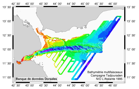
Swath bathymetry – Tadjouraden cruise – R/V L’Atalante 1995 - 250m
EM12 and EM 950 surveys + gravimetry, magnetism and rapid digital seismics to study the mechanism of the ocean ridge's propagation from the Gulf of Aden towards the west(gulf of Tadjoura and Ghoubbet).
Simple
- Date ( Creation )
- 2002-01-31
- Identifier
- IFR_MBAN_DORSALES_INDIEN_TADJOURADEN_BATHY_250_R
- Identifier
- DOI:10.12770/c23d1636-a3cd-4cc9-b141-360277ec0e01
- Credit
- The project is part of the national program Dorsales and represents the French contribution to the InterRidge Data Banks project (see InterRidge News 1997, vol. 6/1 and 1999, vol. 8/1).
Publisher
Ifremer
+33 (0)2 98.22.46.44
http://www.ifremer.fr/sismer/
Centre IFREMER de Brest BP 70
,
PLOUZANE
,
29280
,
France
+33 (0)2 98.22.49.16
+33 (0)2 98.22.46.44
http://www.ifremer.fr/sismer/
- Thèmes Sextant Thèmes Sextant ( Theme )
-
- /Physical Environment/Bathymetry/Digital Terrain Model
- GEMET - INSPIRE themes, version 1.0 GEMET - INSPIRE themes, version 1.0 ( Theme )
-
- Elevation
- Type de jeux de donnée ODATIS Type de jeux de donnée ODATIS ( Theme )
-
- /Processed data/Composite products
- Thématiques - SIMM Thématiques - SIMM ( Theme )
-
- Recherche
- Thématiques - SIMM Thématiques - SIMM ( Theme )
-
- /Etat du Milieu/Bathymétrie
- Sous-regions marines Sous-regions marines ( Place )
-
- /Outre-mer/Océan Indien
- Use limitation
- CC-BY (Creative Commons - Attribution)
- Access constraints
- Other restrictions
- Use constraints
- License
- Other constraints
- Hébert H., Deplus C., Huchon P., Khanbari K. et Audin L., 2001 - Lithospheric structure of a nascent spreading ridge inferred from gravity data: the western Gulf of Aden - J. Geophys. Res., 106 (B11), 26,345-26,363.
- Spatial representation type
- Grid
- Denominator
- 25000
- Metadata language
- fr
- Character set
- UTF8
- Topic category
-
- Elevation
N
S
E
W
))
- Begin date
- 1995-08-21
- End date
- 1995-09-08
- Reference system identifier
- EPSG / WGS 84 (EPSG:4326) / 8.6
- Number of dimensions
- 2
- Dimension name
- Column
- Resolution
- 0.25 kilomètres
- Dimension name
- Row
- Resolution
- 0.25 kilomètres
- Cell geometry
- Area
- Distribution format
-
-
(
)
-
(
)
- OnLine resource
-
IFR_MBAN_DORSALES_INDIEN_TADJOURADEN_BATHY_250_R
(
OGC:WMS
)
Bathymétrie à 250m de résolution
- Protocol
- COPYFILE
- Name
- IFR_MBAN_DORSALES_INDIEN_TADJOURADEN_BATHY_250_R
- Description
- Bathymétrie 250m - format .tif
- OnLine resource
-
DOI du jeu de données
(
WWW:LINK-1.0-http--metadata-URL
)
DOI du jeu de données
- Protocol
- COPYFILE
- Name
- IFR_MBAN_DORSALES_INDIEN_TADJOURADEN_BATHY_250_R_GRD
- Description
- Bathymétrie 250m - format .grd
- OnLine resource
- DOI de la campagne - TADJOURADEN ( WWW:LINK )
- Hierarchy level
- Dataset
- Statement
- Sources : Données de la campagne J. Charcot 1988, données Seabeam
- Description
- 0 spline en tension (surface)
- Rationale
- Interpolation
- Description
- Masquage à partir des données bathymétriques avec l’opérateur grdmask (rayon 5 km)
- Rationale
- Masquage
Content Information
No information provided.
- File identifier
- c23d1636-a3cd-4cc9-b141-360277ec0e01 XML
- Metadata language
- fr
- Character set
- UTF8
- Hierarchy level
- Dataset
- Date stamp
- 2021-09-09T15:33:21
- Metadata standard name
- ISO 19115:2003/19139 - SEXTANT
- Metadata standard version
- 1.0
Overviews
tadji.png
Spatial extent
N
S
E
W
Provided by

Associated resources
Not available