 Mon GéoSource
MSFD - Marine Reports Unit (France)
Simple
- Alternate title
- dcsmm_sous_regions_marines
- Date ( Creation )
- 2010-09-01T15:14:00
- Date ( Publication )
- 2011-02-01
- Date ( Revision )
- 2016-07-19
- Date ( Revision )
- 2016-09-05
- Date ( Revision )
- 2017-06-27T15:05:00
- Edition date
- 2010-09-01
- Identifier
- FR-130-002-736-00028-DCSMM_MRU_P
- Presentation form
- Digital map
- Other citation details
- AAMP, 2016
- Purpose
- Spatialisation des découpages géographiques de référence utilisés en application de la directive cadre stratégie pour le milieu marin
- Credit
- Office français de la biodiversité
- Status
- On going
- Maintenance and update frequency
- As needed
- Thèmes Sextant Thèmes Sextant ( Theme )
-
- /Regulation and Management/Marine Administrative Data
- Keywords ( Theme )
-
- maritime boundary
- MSFD
- sous-régions marines
- eaux françaises métropolitaines
- Open Data
- Marine Reports Units
- MRU
- SRM
- Keywords ( Place )
-
- France
- Keywords ( Discipline )
-
- geographic Information
- GEMET - INSPIRE themes, version 1.0 GEMET - INSPIRE themes, version 1.0 ( Theme )
-
- Sea regions
- Cadre Réglementaire - SIMM Cadre Réglementaire - SIMM ( Theme )
-
- Directive Cadre Stratégie pour le Milieu Marin (DCSMM)
- Directive Cadre pour la Planification de l'Espace Maritime (DCPEM)
- Type de jeux de donnée ODATIS Type de jeux de donnée ODATIS ( Theme )
-
- /Administrative data
- Thématiques - SIMM Thématiques - SIMM ( Theme )
-
- Concrete action
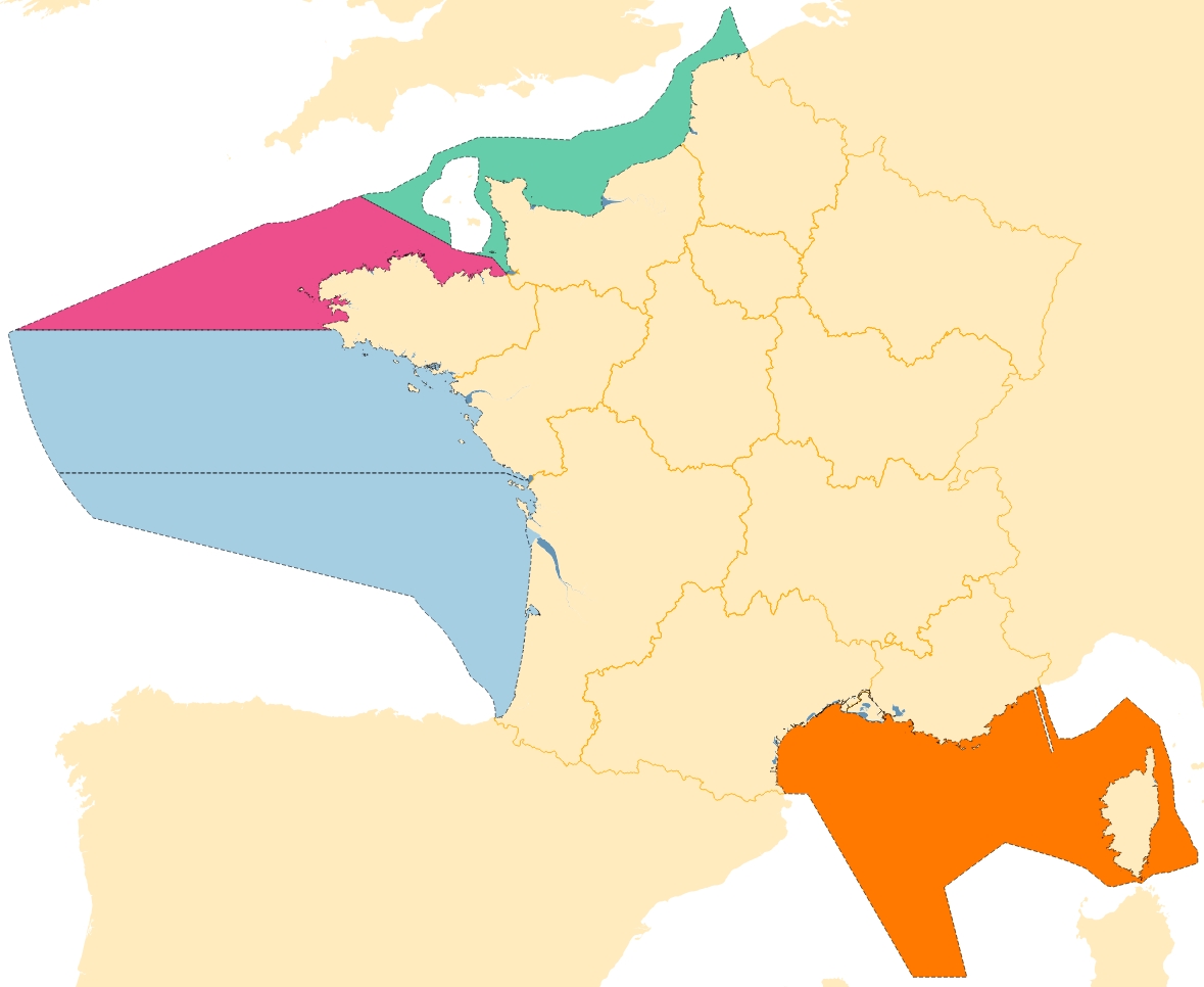
- Sous-regions marines Sous-regions marines ( Place )
-
- /Metropolitan France/Western Mediterranean
- /Metropolitan France/Celtic Seas
- /Metropolitan France/Bay of Biscay
- /Metropolitan France/Channel-North Sea
- Ocean Hackathon - Ville Ocean Hackathon - Ville ( Place )
-
- Boulogne-sur-Mer
- Brest
- La Rochelle
- Sète
- Toulon
- Use limitation
- Change and distribution of data is prohibited without the consent of the distributor. Use prohibited for commercial use.
- Access constraints
- License
- Use constraints
- Intellectual property rights
- Spatial representation type
- Vector
- Denominator
- 25000
- Metadata language
- fr
- Character set
- UTF8
- Topic category
-
- Boundaries
))
- Supplemental Information
-
The attribute table has 6 fields:
- ZONE: takes values "terre" (earth), "12MN", "ZEE", "ZPE";
- ZONE_1: takes values "terre" (earth), "océan atlantique", "mer méditerranée"
- ZONE_3: takes values "MAN", "ATL", "MED";
- SS_REGION: takes values names subregions MSFD;
- PAYS: takes the value of the name of the country at sea and on land;
- REGION: takes values of names of French regions
- Reference system identifier
- WGS84 géographique / 4326
- Topology level
- Geometry only
- Distribution format
-
-
ESRI Shapefile
(
1.0
)
-
ESRI Shapefile
(
1.0
)
- OnLine resource
-
DCSMM_MARINE_REPORTS_UNIT_2020_P
(
OGC:WMS
)
French marine reports units 2020
- Protocol
- FILE
- Name
- DCSMM_MARINE_REPORTS_UNIT_2020_P
- Description
- French marine reports units 2020
- OnLine resource
-
DCSMM_MARINE_REPORTS_UNIT_2020_P
(
OGC:WFS
)
French marine reports units 2020 (wfs)
- OnLine resource
- Dictionnaire de données des zones de gestion DCSMM ( WWW:LINK )
- OnLine resource
-
DCSMM_MARINE_REPORTS_UNIT_2018_P
(
OGC:WMS
)
French marine reports units 2018
- Protocol
- FILE
- Name
- DCSMM_MARINE_REPORTS_UNIT_2018_P
- Description
- French marine reports units 2018
- OnLine resource
-
DCSMM_MARINE_REPORTS_UNIT_2018_P
(
OGC:WFS
)
French marine reports units 2018 (wfs)
- OnLine resource
-
DCSMM_MARINE_REPORTS_UNIT_P
(
OGC:WMS
)
French marine reports units 2017
- Protocol
- FILE
- Name
- DCSMM_MARINE_REPORTS_UNIT_P
- Description
- French marine reports units 2017
- OnLine resource
-
DCSMM_MARINE_REPORTS_UNIT_P
(
OGC:WFS
)
French marine reports units 2017 (wfs)
- Hierarchy level
- Dataset
- Statement
-
The GIS layer is constructed from a variety of sources
- Histolitt v2 Coastline, source SHOM and IGN;
- French Maritime Boundaries, source SHOM;
- French Transitional waters according to the Water Directive Framework, source Sandre 2016;
- Reporting Unit areas from OSPAR Convention, source OSPAR;
- The Franco-Italian maritime delimitation agreement signed on 21 March 2015 (see http://www.shom.fr/fileadmin/data-www/01-LE_SHOM/02-ACTUALITES/01-LES_COMMUNIQUES/2015/France-front-mar_carte-RCO.jpg )
- Feature catalogue citation
- File identifier
- c4e0c660-9ef9-475d-a73f-ac8c669e8924 XML
- Metadata language
- fr
- Character set
- UTF8
- Parent identifier
- fed29b44-a074-4025-a23c-dfa59942f458 fed29b44-a074-4025-a23c-dfa59942f458
- Hierarchy level
- Dataset
- Date stamp
- 2022-06-30T12:28:14.865Z
- Metadata standard name
- ISO 19115:2003/19139 - SEXTANT
- Metadata standard version
- 1.0
0298338777
Overviews
Spatial extent
Provided by
