 Mon GéoSource
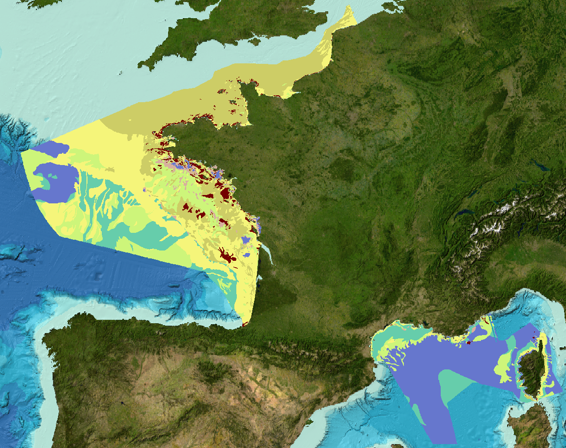
EMODNet Geology (phase 2) - Sediment substrate map at 1 : 1 000 000 of the French metropolitan EEZ
Simple
- Date ( Publication )
- 2017-04-14
02 98 22 45 70
02 98 22 45 70
02 98 22 45 70
- Credit
- Ifremer, BRGM, SHOM, Université de Bordeaux 1
- Thèmes Sextant Thèmes Sextant ( Theme )
-
- /Physical Environment/Sedimentology Geology/Seabed Nature
- GEMET - INSPIRE themes, version 1.0 GEMET - INSPIRE themes, version 1.0 ( Theme )
-
- Geology
- Keywords ( Discipline )
-
- Sedimentology
- Keywords ( Place )
-
- France metropiltan EEZ
- english Channel, Bay of Biscay, Mediterranean sea
- Sous-regions marines Sous-regions marines ( Place )
-
- /Métropole
- Thématiques - SIMM Thématiques - SIMM ( Theme )
-
- /Etat du Milieu/Géologie
- Recherche
- Type de jeux de donnée ODATIS Type de jeux de donnée ODATIS ( Theme )
-
- /Processed data/Composite products
- Use limitation
- Données sous Licence Creative Commons - Attribution + Pas d’Utilisation Commerciale + Partage dans les mêmes conditions (BY-NC-SA) : http://creativecommons.fr/licences/
- Access constraints
- Copyright
- Use constraints
- Other restrictions
- Other constraints
- Copyright European Commission – EMODNet Geology
- Spatial representation type
- Vector
- Denominator
- 1000000
- Metadata language
- fr
- Character set
- UTF8
- Topic category
-
- Oceans
))
- Supplemental Information
-
Description of Attribute table
Code : Two letter country code, which corresponds to ISO3166- code (http://www.iso.org/iso/english_country_names_and_code_elements) and unique numerical identifier for each map. The code should be the same as the code in the INDEX map.
Grain_Size : grain-size classification system used in the original map
Reclassifi : Reclassification. Are the surface substrates reclassified on the basis of sample data or by expert-judgement?
S = Sample-based
P = Expert based prediction
Method : Is the sediment data interpolated automatically from the surface samples or are the existing sediment categories reclassified on the basis of surface material?
1 = automatic interpolation of reclassified samples,
2 = automatic interpolation of reclassified samples and acoustic-seismic-surveys,
3 = reclassification of existing substrate categories on the grounds of analyzed surface samples,
4 = reclassification of existing substrate categories on the grounds of expert-based predicted surface material, no validation.
Sample_n : Approximate the minimum number of samples used per original substrate category.
O_substrat : Original substrate category. Name of the original substrate category. Please, note that for France, numerical identifier have been attributed to substrate category as all original map were restricted in use.
Relation : Code describes the relationship between two classification schemes (original versus reclassified)
=, O_substrate is same as Folk
~ , O_substrate is nearly the same as Folk
> , Folk is contained within O_substrate
< , O_substrate is contained within Folk
# , O_substrate partially overlaps with Folk
FOLK_16cl : Folk classification, 16 facies
111 = Mud
112 = (gravelly) Mud
121 = sandy Mud
122 = (gravelly) sandy Mud
131 = muddy Sand
132 = (gravelly) muddy Sand
211 = Sand
212 = (gravelly) Sand
311 = gravelly Sand
321 = sandy Gravel
331 = Gravel
411 = gravelly Mud
421 = muddy Gravel
431 = gravelly muddy Sand
441 = muddy sandy Gravel
5 = Rock & boulders
6 = no data at this level
7 = In progress
8 = Broad scale data
9 = Restricted data
FOLK_7cl : Folk classification, 7 facies
11 = Mud
12 = sandy Mud
13 = muddy Sand
2 = Sand
3 = Coarse-grained sediment
4 = Mixed sediment
5 = Rock & boulders
6 = no data at this level
7 = In progress
8 = Broad scale data
9 = Restricted data
FOLK_5cl : classification Folk 5 facies
1 = Mud to muddy Sand
2 = Sand
3 = Coarse-grained sediment
4 = Mixed sediment
5 = Rock & boulders
6 = no data at this level
7 = In progress
8 = Broad scale data
9 = Restricted data
Comments : free comment
References : Bibliographical references
- Reference system identifier
- EPSG / WGS 84 (EPSG:4326) / 8.6
- Geometric object type
- Surface
- Distribution format
-
-
ESRI Shapefile
(
1.0
)
-
ESRI Shapefile
(
1.0
)
- OnLine resource
-
EMODNet Geology
(
WWW:LINK
)
EMODNet Geology
- OnLine resource
-
FaciesSedimentaires_1M_EMODNetGeology_Simplet_2016
(
OGC:WMS
)
Carte des formations superficielles à 1 : 1 000 000
- OnLine resource
-
FaciesSedimentaires_1M_EMODNetGeology_Simplet_2016
(
OGC:WFS
)
Carte des formations superficielles à 1 : 1 000 000
- OnLine resource
-
Indexation_Fiabilite_Cartes_EMODNetGeology_Simplet_2016
(
OGC:WMS
)
Indexation et carte de fiabilité des données source
- OnLine resource
-
Indexation_Fiabilite_Cartes_EMODNetGeology_Simplet_2016
(
OGC:WFS
)
Indexation et carte de fiabilité des données source
- Hierarchy level
- Dataset
- Statement
-
This map is based on a compilation of data made available with free access for the project.
Please note that the final project product at Pan-European scale (available at http://www.emodnet-geology.eu/geonetwork/srv/fre/catalog.search#/home ) may be slightly different at borders due to additional data that could have been delivered by the neighbouring countries (Spain for example).
This product have been realised according to original maps' harmonisation et generalisation methodologies (Väänänen et al., 2007) defined by the leaders of the work package 3 (GTK, Finnish Geological Survey) of the European project EMODNet Geology, phase 2.
Sediment classification adopted is Folk, 1954 according 5, 7 or 16 classes.
An additionnal information layer is available. It corresponds to an Index and confidence map of the original seabed sediment maps submitted by France to work-package 3 of EMODnet Geology phase 2 project. Each indexed maps was assigned a confidence score using the “3 step confidence method” developed by the Joint Nature Conservation Council (Three-step confidence assessment framework for classified seabed maps, H. Elwood, JNCC). The attribute table contains the following informations:
Code : Two letter country code, which corresponds to ISO3166- code (http://www.iso.org/iso/english_country_names_and_code_elements) and unique numerical identifier for each map.
Name : Original title of the map
DataHolder : institution holding the map
Contact : name and email of the contact to get access or information about data
Scale : original map's scale
5 = 1: 50 000 or more detailed
4 = 1: 50 001 - 100 000
3 = 1: 100 001 - 250 000
2 = 1: 250 001 - 500 000
1 = 1: 500 001 - 1 000 000
Grain_Size : grain-size classification system used in the original map
Ref. : bibliographical reference
Comments : free comment
RS : "Remote sensing" ; Score attributed for remote sensing coverage. 0= No remote sensing, 1= remote sensing coverage is moderate or poor (<90%) ; 2= remote sensing coverage is good (up to 90%).
S :"Amount of samples" ; 1= every class/polygon was sampled ; 0= not every class/polygon was sampled
D : "Distinctness of class boundaries" ; 1= predicted class boundaries are distinct ; 0= predicted class boundaries are less distinct
CONF_TOT : Score for confidence calculated as CONF_TOT= RS+S+D
References
Coltman, N., Gilliland, P. & van Heteren, S. 2007. What can I do with my map? In: MESH Guide to Habitat Mapping, MESH Project, 2007, JNCC, Peterborough. Available online at:
(http://www.searchmesh.net/default.aspx?page=1900)
Foster-Smith, R., Connor, D. & Davies, J. 2007. What is habitat mapping? In: MESH Guide to Habitat Mapping, MESH Project, 2007, JNCC, Peterborough. Available
online at: (http://www.searchmesh.net/default.aspx?page=1900)
Väänänen, T. (ed), Hyvönen, E., Jakonen, M., Kupila, J., Lerrsi, J., Leskinen, J., Liwata, P., Nevalainen, R., Putkinen, S., Virkki, H. 2007. Maaperän yleiskartan tulkinta- ja kartoitusprosessi. Maaperän yleiskartoitus –hankkeen sisäinen raportti. 17 p.
- File identifier
- c540dc17-299b-470a-b71c-fa9934c93847 XML
- Metadata language
- fr
- Character set
- UTF8
- Hierarchy level
- Dataset
- Date stamp
- 2021-07-29T15:18:21
- Metadata standard name
- ISO 19115:2003/19139 - SEXTANT
- Metadata standard version
- 1.0
02 98 22 45 70
Overviews
Spatial extent
Provided by
