 Mon GéoSource
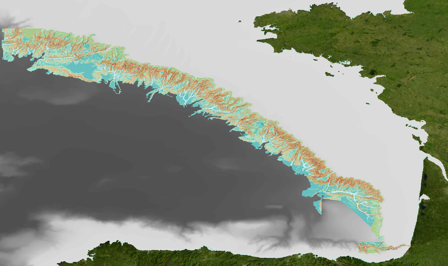
Geomorphological classification of the continental slope of the Bay of Biscay (1/500 000)
Simple
- Date ( Publication )
- 2016-05-11
- Identifier
- DOI:10.12770/d5da916a-163c-47b9-8a8e-73dcaeec7986
Cited responsible party
- Credit
- Ifremer, Géosciences Marines & Études des Écosystèmes Profonds
02 98 22 47 57
02 98 22 45 70
02 98 22 45 49
02 29 00 85 47
02 29 00 85 47
- Maintenance and update frequency
- Not planned
- Thèmes Sextant Thèmes Sextant ( Theme )
-
- /Physical Environment/Sedimentology Geology/Geomorphology
- GEMET - INSPIRE themes, version 1.0 GEMET - INSPIRE themes, version 1.0 ( Theme )
-
- Geology
- Keywords ( Discipline )
-
- Geomorphology
- Cartographie
- Classification
- Keywords ( Place )
-
- Bay of Bisacay
- Sous-regions marines Sous-regions marines ( Place )
-
- /Metropolitan France/Bay of Biscay
- Thématiques - SIMM Thématiques - SIMM ( Theme )
-
- /Etat du Milieu/Bathymétrie
- /Environmental Status/Geology
- Research
- /Uses and Human Activities/Industry and energy
- Type de jeux de donnée ODATIS Type de jeux de donnée ODATIS ( Theme )
-
- /Processed data/Composite products
- Use limitation
- Data can't be copy, distribute, change or supply to third parties, for commercial purpose without the prior agreement of Ifremer
- Access constraints
- Copyright
- Use constraints
- Copyright
- Other constraints
- Obligation of citation
- Spatial representation type
- Vector
- Denominator
- 500000
- Metadata language
- fr
- Character set
- UTF8
- Topic category
-
- Geoscientific information
))
- Reference system identifier
- EPSG / WGS 84 (EPSG:4326) / 8.6
- Topology level
- Geometry only
- Geometric object type
- Complex
- Distribution format
-
-
ESRI Shapefile
(
10
)
-
ESRI Shapefile
(
10
)
- OnLine resource
-
Dataset DOI
(
WWW:LINK-1.0-http--metadata-URL
)
Dataset DOI
- OnLine resource
-
Archimer documentation - CoralFish
(
WWW:LINK
)
Géomorphologic Classification - CoralFish
- OnLine resource
-
Archimer documentation - Maps
(
WWW:LINK
)
Maps - CoralFish
- OnLine resource
-
cmecscatalog.org
(
WWW:LINK
)
CMECS Classification
- OnLine resource
-
data.ifremer.fr
(
WWW:LINK
)
data.ifremer.fr portal
- OnLine resource
- Campagne BOBGEO 1 ( WWW:LINK )
- OnLine resource
- Campagne BOBGEO 2 ( WWW:LINK )
- OnLine resource
- Campagne ZEE 1 ( WWW:LINK )
- OnLine resource
- Campagne ZEE 2 ( WWW:LINK )
- OnLine resource
- Campagne SEDIMANCHE 1 ( WWW:LINK )
- OnLine resource
- Campagne SEDIFAN 1 ( WWW:LINK )
- OnLine resource
- Campagne SEDIFAN 2 ( WWW:LINK )
- OnLine resource
- Campagne ESSNAUT 2009 ( WWW:LINK )
- OnLine resource
- Campagne ESSRESON 08-1 ( WWW:LINK )
- OnLine resource
- Campagne ESSRESON 08-2 ( WWW:LINK )
- OnLine resource
- Campagne ESSINF ( WWW:LINK )
- OnLine resource
- Campagne VALIDOP ( WWW:LINK )
- OnLine resource
-
IFR_GEOMORPHO_PENTE_GDG_100M_2015_P
(
OGC:WMS
)
Classification géomorphologique GdG 100m 2015
- Hierarchy level
- Dataset
Conformance result
- Date ( Creation )
- 2012-01-16
- Explanation
- Non évalué
- Pass
- No
- Statement
-
Geomorphological analysis of the continental slope of the Bay of Biscay based on a 100m Data Terrain Model (DTM). This DTM is a synthesis of data acquired during sea surveys ZEE 1, ZEE 2, Sedimanche, Sedifan 1, Sedifan 2, EssNaut 2009, EssReson08, ValidOp, BOBGeo 1, BOBGeo 2, EssInf.
The geomorphological classification was developed for the geomorphological maps at a scale of 1.100,000 in the framework of the European FP7 project Coralfish (Bourillet J-F. (Coord.), de Chambure L., Loubrieu B., 2012. Sur les traces des coraux d'eau froide du golfe de Gascogne. 8 cartes bathymorphologiques et géomorphologiques au 1/100.000. Cold water corals of the Bay of Biscay: 8 bathymorphological and geomorphological maps at 1:100,000., Editions Quae ed.).
It is base on geostatistical methods (de Chambure L., Bourillet, J-F., Bartel, C., 2013, Geomorphological classification in Bay of Biscay. Morpho-sedimentary mapping of the seabed in selected areas. Rapport INT. Ifremer-REM/GM/LES, 51p.).
Parameters, directly derived from the bathymetry (average depth, regional and local slope, …) allow the delimitation of the main physiographic sectors (megageoforms) such as shelf, slope and continental rise.
More complex parameters (drainage networks, thalwegs, weighted distance to the nearest thalweg) point out the geological structures : on the northern continental margin of theBay of Biscay, canyons are major elements of the shape of the sea floor (Bourillet et al., 2006). These parameters are used to differentiate canyons to interfluves areas.
Meso and macrogeoforms (km and 10xkm) are then classified within the canyon areas (river bed, flank, fall, gully, …) and the interfluve areas (crest, terrace, escarpment, …) and their connectivity is checked. These geoforms are also identified accordoing to the CMECS standard, Coastal and Marine Ecological Classification Standard (Madden, C, et al., 2008. Coastal and Marine Ecological classification Standard. NOAA and NatureServe. 77p. ; Greene, H.G., et al., 2007a. Construction of digital potential marine benthic habitat maps using a coded classification scheme and its application. In: B.J. Todd and H.G. Greene (eds.), Mapping the seafloor for habitat characterization. Geol. Assoc. Can. Spec. Pap. 47, pp. 141-155).
Shapefile was built from geostatistical interpretation DTM (Isatis software) using conversion tool "Raster to polygon" from ArcGIS software with the option "simplify polygons" ticks.
- File identifier
- d5da916a-163c-47b9-8a8e-73dcaeec7986 XML
- Metadata language
- fr
- Character set
- UTF8
- Hierarchy level
- Dataset
- Date stamp
- 2020-06-04T00:30:39
- Metadata standard name
- ISO 19115:2003/19139 - SEXTANT
- Metadata standard version
- 1.0
02 98 22 45 70
Overviews
Spatial extent
Provided by
