 Mon GéoSource
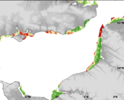
Species and habitats - Platichthys flesus - Nurseries French Coasts - Multi-annual abundance in September - Kriging error map
Abundance of several species in coastal nurseries along french coasts. Kriging error (v) resulting from the interpolation of these data was maped.
Simple
- Autres appellations ou acronymes
- FYFS_species_geostatS
- Date ( Publication )
- 2009-12-31T00:00:00
- Identificateur
- CHARM_PLATFLE_NURS_FYFS_KRIG_ERR_R
- Forme de la présentation
- Carte numérique
- Autres informations de référence
- Source CHARM Consortium
- Reconnaissance
- IFREMER
- Reconnaissance
- CHARM consortium
- Etat
- Finalisé
- Fréquence de mise à jour
- Lorsque nécessaire
- Thèmes Sextant ( Thème )
-
- /Biological Environment/Species/Fish Species of Commercial Interest
- Mots clés ( Discipline )
-
- Species data set
- CHARM
- GEMET - INSPIRE themes, version 1.0 ( Thème )
-
- Répartition des espèces
- external.theme.gemet ( Thème )
-
- ressource halieutique
- Limitation d'utilisation
- research-only
- Contraintes d'accès
- Licence
- Autres contraintes
- Has to be cited this way in maps : "Source CHARM Consortium"
- Autres contraintes
- Has to be cited this way in bibliography : "Carpentier A, Martin CS, Vaz S (Eds.), 2009. Channel Habitat Atlas for marine Resource Management, final report / Atlas des habitats des ressources marines de la Manche orientale, rapport final (CHARM phase II). INTERREG 3a Programme, IFREMER, Boulogne-sur-mer, France. 626 pp. & CD-rom"
- Type de représentation spatiale
- Raster
- Dénominateur de l'échelle
- 2500
- Langue
- fr
- Langue
- en
- Jeu de caractères
- Utf8
- Catégorie ISO
-
- Océans
- Biote
- Environnement
- Description de l'environnement de travail
- Microsoft Windows XP ; ESRI ArcGIS 9.x
- Identifiant géographique
- Eastern English Channel
N
S
E
W
))
- Date de début
- 1977-01-01
- Date de fin
- 2006-12-31
- Nom du système de référence
- WGS 84 (EPSG:4326)
- Dimensions
- 2
- Noms des axes
- Axe - X
- Nombre de pixel
- 1288
- Résolution
- 0.009 degree
- Noms des axes
- Axe - Y
- Nombre de pixel
- 618
- Résolution
- 0.009 degree
- Type de raster
- Surface
- Disponibilité des paramètres de transformation
- Non
Distributeur
- Ressource en ligne
-
CHARM web site
(
WWW:LINK
)
CHARM web site
- Ressource en ligne
- CHARM_PLATFLE_NURS_FYFS_KRIG_ERR_R ( OGC:WMS )
- Protocole
- COPYFILE
- Nom
- CHARM_PLATFLE_NURS_FYFS_KRIG_ERR_R
- Niveau
- Jeu de données
- Généralités sur la provenance
- Between 1977 and 2006, in September, IFREMER conducted French Young Fish Surveys alond the French coasts. This dataset comprises data from four surveys covering different periods (Bay of Veys, 1977-1981; Bay of Seine, 1995-2002; Bay of Somme, 1998-2006; DYFS, 1977-1983). The French YFs taking place in the Bays of Somme and Seine uses a 3 m beam trawl outside of the bays, but a 2 m beam trawl witin the bays. Data have sometimes been standardised to take into account the difference in gear characteristics.
- Description
- Kriging produces an estimation of the interpolation error (measured as an estimation variance), whereas classical interpolation methods, based on arbitrary mathematical functions, cannot estimate it. Moreover, this error is reduced as much as possible as the kriging predictor minimises it by definition. Indeed, for each estimation, the weights given to neighbouring observations are computed from the variogram model and are derived so as to minimise the estimation variance. As a result, for mapping purposes, kriged interpolation produces a large field of estimates at points or blocks and corresponding kriging error.The kriging error grids of points resulting from the interpolation of biological parameters were imported into ArcMap and interpolated with the Spatial Analyst extension in order to create a continuous raster of 1 km² resolution. The resulting maps illustrate the interpolation error of each parameter.
- Description
- FYFS surveys, scientific surveys from IFREMER
- Identifiant de la fiche
- e0bc0e09-68ca-45d4-bc03-8ab0a040caed XML
- Langue
- en
- Jeu de caractères
- Utf8
- Type de ressource
- Jeu de données
- Date des métadonnées
- 2020-06-04T00:26:33
- Nom du standard de métadonnées
- ISO 19115:2003/19139 - SEXTANT
- Version du standard de métadonnées
- 1.0
Aperçus
Étendue spatiale
N
S
E
W
Fourni par

Ressources associées
Not available