 Mon GéoSource
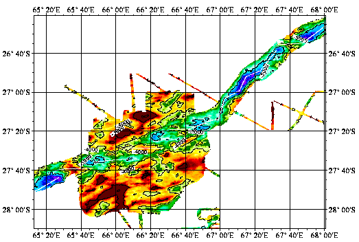
The southwest indian ridge between 65°E and 68°E - 120m
Reconnaissance geophysique, geologique, petrographique et geochimique systematique du point triple de Rodriguez ou convergent trois dorsales medio-oceanique. Exploration geophysique, geologique, petrographiqueet geochimique d'un segment de la zone axiale de chacune des trois dorsales. Reconnaissance, dans le bassin de Wharton, d'une dorsale fossile.
Simple
- Date ( Creation )
- 2000-01-26
- Identifier
- IFR_MBAN_DORSALES_INDIEN_SWIR65_68_BATHY_120_R
- Identifier
- DOI:10.12770/e54561cf-a7aa-4336-a935-7cfec6e1cdbb
- Credit
- The project is part of the national program Dorsales and represents the French contribution to the InterRidge Data Banks project (see InterRidge News 1997, vol. 6/1 and 1999, vol. 8/1).
Publisher
Ifremer
+33 (0)2 98.22.46.44
http://www.ifremer.fr/sismer/
Centre IFREMER de Brest BP 70
,
PLOUZANE
,
29280
,
France
+33 (0)2 98.22.49.16
+33 (0)2 98.22.46.44
http://www.ifremer.fr/sismer/
- Thèmes Sextant Thèmes Sextant ( Theme )
-
- /Physical Environment/Bathymetry/Digital Terrain Model
- GEMET - INSPIRE themes, version 1.0 GEMET - INSPIRE themes, version 1.0 ( Theme )
-
- Elevation
- Thématiques - SIMM Thématiques - SIMM ( Theme )
-
- /Environmental Status/Bathymetry
- /Environmental Status/Geology
- Type de jeux de donnée ODATIS Type de jeux de donnée ODATIS ( Theme )
-
- /Processed data/Composite products
- Sous-regions marines Sous-regions marines ( Place )
-
- /Overseas France/Indian Ocean
- Thématiques - SIMM Thématiques - SIMM ( Theme )
-
- Research
- Use limitation
- CC-BY (Creative Commons - Attribution)
- Access constraints
- Other restrictions
- Use constraints
- License
- Other constraints
- Mendel V., Sauter D., Parson L., and Vanney J.R., 1997. Segmentation and morphotectonic variations along an ultra-slow spreading centre: the Southwest Indian Ridge (57˚E - 70˚E). Mar. Geophys. Res., 19, p. 505-553
- Spatial representation type
- Grid
- Denominator
- 25000
- Metadata language
- fr
- Character set
- UTF8
- Topic category
-
- Elevation
N
S
E
W
))
- Reference system identifier
- EPSG / WGS 84 (EPSG:4326) / 8.6
- Number of dimensions
- 2
- Dimension name
- Column
- Resolution
- 0.001249 degres
- Dimension name
- Row
- Resolution
- 0.00109 degres
- Cell geometry
- Area
- Distribution format
-
-
(
)
-
(
)
- OnLine resource
-
MOHNS_BATHY
(
OGC:WMS
)
Bathymetry (WMS)
- Protocol
- FILE
- Name
- MOHNS_BATHY
- Description
- Bathymétrie - format .tif and .grd
- OnLine resource
-
DOI du jeu de données
(
WWW:LINK-1.0-http--metadata-URL
)
DOI du jeu de données
- Protocol
- COPYFILE
- Name
- IFR_MBAN_DORSALES_INDIEN_SWIR65_68_BATHY_120_R_GRD
- Description
- Bathymétrie 120m - format .grd
- OnLine resource
- DOI de la campagne - RODRIGUEZ(1ER LEG) ( WWW:LINK )
- OnLine resource
- DOI de la campagne - RODRIGUEZ(2EME LEG) ( WWW:LINK )
- OnLine resource
- DOI de la campagne - CAPSING ( WWW:LINK )
- Hierarchy level
- Dataset
- Statement
- Sources : Données de la campagne J. Charcot 1988, données Seabeam
- Description
- 0 spline en tension (surface)
- Rationale
- Interpolation
- Description
- Un lissage par recherche de la médiane locale dans une matrice carrée 3x3 a été appliqué aux grilles bathymétriques. Ce lissage, équivalent d’un filtre passe-bas, effectue un classement par valeur croissante des pixels voisins du pixel courant et affecte à ce dernier la valeur médiane des pixels classés. L’avantage d’un tel lissage est d’éliminer les pics ponctuels sans dégrader la qualité de l’image initiale.
- Rationale
- Lissage
Content Information
No information provided.
- File identifier
- e54561cf-a7aa-4336-a935-7cfec6e1cdbb XML
- Metadata language
- fr
- Character set
- UTF8
- Hierarchy level
- Dataset
- Date stamp
- 2022-05-25T13:10:07.585Z
- Metadata standard name
- ISO 19115:2003/19139 - SEXTANT
- Metadata standard version
- 1.0
Overviews
Capture.PNG
Spatial extent
N
S
E
W
Provided by

Associated resources
Not available