 Mon GéoSource
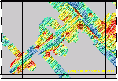
Multibeam bathymetry - Zone 1 - Pacantarctic cruise - 250m/500m/1000m
Simple
- Date ( Creation )
- 2002-11-26
- Identifier
- IFR_MBAN_DORSALES_PACIF_ZONE1_BATHY_R
- Identifier
- DOI:10.12770/f36e283e-f7bc-4497-91e4-308a40d723b2
- Credit
- The project is part of the national program Dorsales and represents the French contribution to the InterRidge Data Banks project (see InterRidge News 1997, vol. 6/1 and 1999, vol. 8/1).
+33 (0)2 98.22.46.44
http://www.ifremer.fr/sismer/
- Thèmes Sextant Thèmes Sextant ( Theme )
-
- /Physical Environment/Bathymetry/Digital Terrain Model
- GEMET - INSPIRE themes, version 1.0 GEMET - INSPIRE themes, version 1.0 ( Theme )
-
- Elevation
- Type de jeux de donnée ODATIS Type de jeux de donnée ODATIS ( Theme )
-
- /Processed data/Composite products
- Thématiques - SIMM Thématiques - SIMM ( Theme )
-
- /Etat du Milieu/Bathymétrie
- Thématiques - SIMM Thématiques - SIMM ( Theme )
-
- Recherche
- Sous-regions marines Sous-regions marines ( Place )
-
- /Outre-mer/Océan Indien
- Use limitation
- CC-BY (Creative Commons - Attribution)
- Access constraints
- Other restrictions
- Use constraints
- License
- Other constraints
- Géli, L., et al., Evolution of the Pacific-Antarctic Ridge south of the Udintsev Fracture Zone, Science, 278, 1281-1284, 1997
- Spatial representation type
- Grid
- Denominator
- 25000
- Metadata language
- fr
- Character set
- UTF8
- Topic category
-
- Elevation
))
- Reference system identifier
- EPSG / WGS 84 (EPSG:4326) / 8.6
- Number of dimensions
- 3
- Dimension name
- Column
- Resolution
- 0.2861653 minutes
Axis Dimensions Properties
- Dimension name
- Row
- Resolution
- 0.12108899 minutes
- Cell geometry
- Area
- Number of dimensions
- 2
- Dimension name
- Column
- Resolution
- 0.63592289 minutes
- Dimension name
- Row
- Resolution
- 0.26909891
- Cell geometry
- Area
- Number of dimensions
- 2
- Dimension name
- Column
- Resolution
- 1.27184578 minutes
- Dimension name
- Row
- Resolution
- 0.53824296 minutes
- Cell geometry
- Area
- Distribution format
-
-
(
)
-
(
)
- OnLine resource
-
MOHNS_BATHY
(
OGC:WMS
)
Bathymetry (WMS)
- Protocol
- FILE
- Name
- MOHNS_BATHY
- Description
- Bathymétrie - format .tif and .grd
- OnLine resource
-
DOI du jeu de données
(
WWW:LINK-1.0-http--metadata-URL
)
DOI du jeu de données
- Protocol
- COPYFILE
- Name
- IFR_MBAN_DORSALES_PACIF_ZONE1_BATHY_250_R_GDR
- Description
- Bathymétrie 250m - format .grd
- OnLine resource
-
IFR_MBAN_DORSALES_PACIF_ZONE1_BATHY_500_R
(
OGC:WMS
)
Bathymétrie à 500m de résolution
- Protocol
- FILE
- Name
- IFR_MBAN_DORSALES_PACIF_ZONE1_BATHY_500_R
- Description
- Bathymétrie 500m - format .tif
- Protocol
- COPYFILE
- Name
- IFR_MBAN_DORSALES_PACIF_ZONE1_BATHY_500_R_GRD
- Description
- Bathymétrie 500m - format .grd
- OnLine resource
-
IFR_MBAN_DORSALES_PACIF_ZONE1_BATHY_1000_R
(
OGC:WMS
)
Bathymétrie à 1000m de résolution
- Protocol
- FILE
- Name
- IFR_MBAN_DORSALES_PACIF_ZONE1_BATHY_1000_R
- Description
- Bathymétrie 1000m - format .tif
- Protocol
- COPYFILE
- Name
- IFR_MBAN_DORSALES_PACIF_ZONE1_BATHY_1000_R_GDR
- Description
- Bathymétrie 1000m - format .grd
- OnLine resource
- DOI de la campagne - PACANTARCTIC ( WWW:LINK )
- Hierarchy level
- Dataset
- Statement
- Sources : Données de la campagne J. Charcot 1988, données Seabeam
- Description
- 0 spline en tension (surface)
- Rationale
- Interpolation
Content Information
- File identifier
- f36e283e-f7bc-4497-91e4-308a40d723b2 XML
- Metadata language
- fr
- Character set
- UTF8
- Hierarchy level
- Dataset
- Date stamp
- 2020-08-31T11:22:42
- Metadata standard name
- ISO 19115:2003/19139 - SEXTANT
- Metadata standard version
- 1.0
Overviews
Spatial extent
Provided by
