 Mon GéoSource
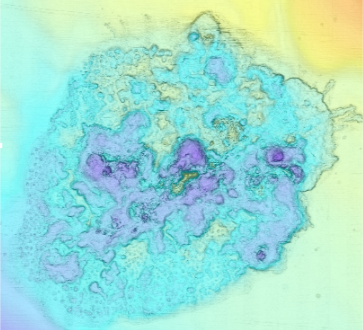
Bathymetry - Congo fan, Regab pockmark (WACS cruise, 2011)
Bathymétrie du pockmark Regab (campagne WACS, 2011), au pas de 25 centimètres. Ce jeu de données est un Modèle Numérique de Terrain bathymétrique, issu de l'acquisition acoustique du sondeur multifaisceaux Resonn Seabat 7125 du N/O Pourquoi Pas?, lors de la campagne WACS, du 26 janvier au 25 février 2011.
Description de la campagne : OLU Karine (2011) WACS cruise, RV Pourquoi pas ?, https://doi.org/10.17600/11030010
Bibliographie :
- Marcon Yann, Ondreas Helene, Sahling Heiko, Bohrmann Gerhard, Olu Karine (2014). Fluid flow regimes and growth of a giant pockmark. Geology, 42(1), 63-66. Publisher's official version : https://doi.org/10.1130/G34801.1 , Open Access version : https://archimer.ifremer.fr/doc/00186/29731/
- Picot M., Droz L., Marsset Tania, Dennielou Bernard, Bez M. (2016). Controls on turbidite sedimentation: Insights from a quantitative approach of submarine channel and lobe architecture (Late Quaternary Congo fan). Marine And Petroleum Geology, 72, 423-446. Publisher's official version : https://doi.org/10.1016/j.marpetgeo.2016.02.004 , Open Access version : https://archimer.ifremer.fr/doc/00312/42285/
Simple
- Date ( Publication )
- 2022-03-24
- Date ( Creation )
- 2011-06-21
- Identifier
- FR-330715-368-00032-WACS_Regab_25cm_BATHY
- Credit
- Ifremer
- Thèmes Sextant Thèmes Sextant ( Theme )
-
- /Physical Environment/Bathymetry
- GEMET - INSPIRE themes, version 1.0 GEMET - INSPIRE themes, version 1.0 ( Theme )
-
- Elevation
- GEMET - Concepts, version 2.4 GEMET - Concepts, version 2.4 ( Theme )
-
- sea bed
- submarine morphology
- Keywords ( Discipline )
-
- Bathymetry
- Access constraints
- Other restrictions
- Use constraints
- License
- Other constraints
- Pas de restriction d'accès public
- Use limitation
- Ne pas utiliser pour la navigation
- Spatial representation type
- Grid
- Denominator
- 500
- Distance
- 0.25 meter
- Metadata language
- fr
- Character set
- UTF8
- Topic category
-
- Oceans
))
- Begin date
- 2011-01-26
- End date
- 2011-02-25
Reference System Information
- Reference system identifier
- EPSG / WGS 84 / World Mercator (EPSG:3395) Parallèle standard 5,5°S / 7.4
Spatial representation info
- Number of dimensions
- 2
- Dimension name
- Row
- Dimension size
- 4869
- Resolution
- 0.25 mètres
- Dimension name
- Column
- Dimension size
- 4802
- Resolution
- 0.25 mètres
- Cell geometry
- Area
- Distribution format
-
-
GeoTIFF
(
1.0
)
-
GeoTIFF
(
1.0
)
- OnLine resource
- Campagne WACS ( WWW:LINK )
- OnLine resource
- WACS_Regab_25cm_BATHY ( OGC:WMS )
- Protocol
- COPYFILE
- Name
- WACS_Regab_25cm_BATHY
- OnLine resource
- Digital Object Identifier (DOI) ( WWW:LINK-1.0-http--metadata-URL )
- Hierarchy level
- Dataset
Conformance result
- Date ( Publication )
- 2010-12-08
- Explanation
- See the referenced specification
- Statement
- Pas d'information sur le traitement réalisé.
- File identifier
- f70a69a5-875a-4a7c-bfd3-803d3311842a XML
- Metadata language
- fr
- Character set
- UTF8
- Hierarchy level
- Dataset
- Date stamp
- 2022-03-24T13:36:05.678Z
- Metadata standard name
- ISO 19115:2003/19139 - SEXTANT
- Metadata standard version
- 1.0
Overviews
Spatial extent
Provided by
