 Mon GéoSource
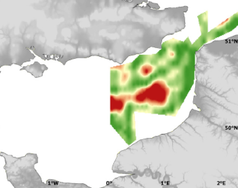
Physical environment - In situ data - Surface salinity collected during the International Bottom Trawl Survey in 2007 - Kriging error
Three environmental parameters were measured in situ during the IBTS in 2007. Temperature and salinity were measured using thermosalinometer 3 to 5 m under sea surface. Sub-surface (3-5 m) chlorophyll a concentration was measured using a fluorometer (measure the fluorescence emitted by the pigment). The IBTS survey, which takes place each year in January, gives a good illustration of winter conditions.
Simple
- Autres appellations ou acronymes
- IBTS_environment_geostatS
- Date ( Publication )
- 2009-12-31T00:00:00
- Identificateur
- CHARM_IBTS_SSAL_KRIG_R
- Forme de la présentation
- Carte numérique
- Autres informations de référence
- Source CHARM Consortium
- Reconnaissance
- IFREMER
- Reconnaissance
- CHARM consortium
- Etat
- Finalisé
Point de contact
Ifremer
-
Yves Verin
(
)
Laboratoire de Ressources Halieutiques, Ifremer, 150 quai Gambetta BP699
,
Boulogne sur mer
,
62321
,
- Fréquence de mise à jour
- Lorsque nécessaire
- Thèmes Sextant ( Thème )
-
- /Physical Environment/Physical Habitats
- Mots clés ( Discipline )
-
- Species data set
- CHARM
- external.theme.gemet ( Thème )
-
- ressource halieutique
- GEMET - INSPIRE themes, version 1.0 ( Thème )
-
- Oceanographic geographical features
- Limitation d'utilisation
- research-only
- Contraintes d'accès
- Licence
- Autres contraintes
- Has to be cited this way in maps : "Source CHARM Consortium"
- Autres contraintes
- Has to be cited this way in bibliography : "Carpentier A, Martin CS, Vaz S (Eds.), 2009. Channel Habitat Atlas for marine Resource Management, final report / Atlas des habitats des ressources marines de la Manche orientale, rapport final (CHARM phase II). INTERREG 3a Programme, IFREMER, Boulogne-sur-mer, France. 626 pp. & CD-rom"
- Type de représentation spatiale
- Raster
- Dénominateur de l'échelle
- 1000
- Langue
- en
- Langue
- fr
- Jeu de caractères
- Utf8
- Catégorie ISO
-
- Biote
- Océans
- Environnement
- Description de l'environnement de travail
- Microsoft Windows XP ; ESRI ArcGIS 9.x
- Identifiant géographique
- Dover strait and southern half of the North Sea
N
S
E
W
))
- Date de début
- 2007-01-01T16:09:00
- Date de fin
- 2007-01-31T09:00:00
- Nom du système de référence
- 4326
- Nom du système de référence
- EPSG / WGS 84 (EPSG:4326) / 7.4
- Dimensions
- 2
- Noms des axes
- Axe - X
- Nombre de pixel
- 334
- Résolution
- 0.009 degree,
- Noms des axes
- Axe - Y
- Nombre de pixel
- 314
- Résolution
- 0.009 degree,
- Type de raster
- Surface
- Disponibilité des paramètres de transformation
- Non
Distributeur
- Ressource en ligne
-
CHARM web site
(
WWW:LINK
)
CHARM web site
- Protocole
- COPYFILE
- Nom
- Kriging error
- Description
- Kriging error
- Ressource en ligne
-
CHARM_IBTS_SSAL_KRIG_R
(
OGC:WMS
)
Kriging error
- Niveau
- Jeu de données
- Généralités sur la provenance
- The survey concerns the Dover Strait to the southern half of the North Sea. Its aim is to estimate fish abundance and distribution and to compute recruitment indices (abundance of juveniles) for the fish species exploited in the North Sea. In parallel to its regular actions, the 2007 French IBTS used a continuous fish egg pumping device called CUFES allowing the collection of information on the spatial distribution of winter spawning areas and on the spawning habitat of several important species.
- Description
- Kriging produces an estimation of the interpolation error (measured as an estimation variance), whereas classical interpolation methods, based on arbitrary mathematical functions, cannot estimate it. Moreover, this error is reduced as much as possible as the kriging predictor minimises it by definition. Indeed, for each estimation, the weights given to neighbouring observations are computed from the variogram model and are derived so as to minimise the estimation variance. As a result, for mapping purposes, kriged interpolation produces a large field of estimates at points or blocks and corresponding kriging error.The kriging error grids of points resulting from the interpolation of environmental parameters were imported into ArcMap and interpolated with the Spatial Analyst extension in order to create a continuous raster of 1 km² resolution. The resulting maps illustrate the interpolation error of each parameter.
- Description
- IBTS survey, scientific survey of IFREMER
- Identifiant de la fiche
- 2ed257d6-4ced-439c-9441-eb34bcaf377b XML
- Langue
- en
- Jeu de caractères
- Utf8
- Type de ressource
- Jeu de données
- Date des métadonnées
- 2020-06-04T00:41:13
- Nom du standard de métadonnées
- ISO 19115:2003/19139 - SEXTANT
- Version du standard de métadonnées
- 1.0
Aperçus
Étendue spatiale
N
S
E
W
Fourni par

Ressources associées
Not available