 Mon GéoSource
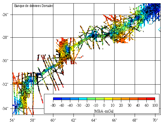
Mantle Bouguer Anomaly grid - South-Ouest Indian Ridge 57°-70°E - 1600m
Compilation of gravimetric data between 1973 and 1994
Simple
- Date ( Creation )
- 2000-07-28
- Identifier
- IFR_MBAN_DORSALES_INDIEN_SWIR57_70_GRAVI_MBA_1600_R
- Identifier
- DOI:10.12770/05c72638-b555-47b7-ab0c-12e988968d51
- Credit
- The project is part of the national program Dorsales and represents the French contribution to the InterRidge Data Banks project (see InterRidge News 1997, vol. 6/1 and 1999, vol. 8/1).
Publisher
Ifremer
+33 (0)2 98.22.46.44
http://www.ifremer.fr/sismer/
Centre IFREMER de Brest BP 70
,
PLOUZANE
,
29280
,
France
+33 (0)2 98.22.49.16
+33 (0)2 98.22.46.44
http://www.ifremer.fr/sismer/
- Thèmes Sextant Thèmes Sextant ( Theme )
-
- /Physical Environment/Sedimentology Geology/Geomorphology
- GEMET - INSPIRE themes, version 1.0 GEMET - INSPIRE themes, version 1.0 ( Theme )
-
- Oceanographic geographical features
- Type de jeux de donnée ODATIS Type de jeux de donnée ODATIS ( Theme )
-
- /Processed data/Composite products
- Thématiques - SIMM Thématiques - SIMM ( Theme )
-
- /Etat du Milieu/Bathymétrie
- /Etat du Milieu/Géologie
- Sous-regions marines Sous-regions marines ( Place )
-
- /Outre-mer/Océan Indien
- Thématiques - SIMM Thématiques - SIMM ( Theme )
-
- Recherche
- Use limitation
- CC-BY (Creative Commons - Attribution)
- Access constraints
- Other restrictions
- Use constraints
- License
- Other constraints
- Rommevaux-Jestin C., Deplus C. and Patriat Ph., 1997 - Mantle Bouguer anomaly along a super-slow spreading ridge : comparison with Mid-Atlantic Ridge and implications on the accretionary processes - Mar. Geophys. Res., 19/5, 481-503.
- Spatial representation type
- Grid
- Denominator
- 25000
- Metadata language
- fr
- Character set
- UTF8
- Topic category
-
- Oceans
N
S
E
W
))
- Begin date
- 1972-01-01
- End date
- 1994-12-30
- Reference system identifier
- EPSG / WGS 84 (EPSG:4326) / 8.6
- Number of dimensions
- 2
- Dimension name
- Column
- Resolution
- 1 minute
- Dimension name
- Row
- Resolution
- 1 minute
- Cell geometry
- Area
- OnLine resource
-
IFR_MBAN_DORSALES_INDIEN_SWIR57_70_GRAVI_MBA_1600_R
(
OGC:WMS
)
Gravimétrie à 1600m de résolution
- Protocol
- FILE
- Name
- IFR_MBAN_DORSALES_INDIEN_SWIR57_70_GRAVI_MBA_1600_R
- Description
- Gravimétrie 1600m - format .tif
- OnLine resource
-
DOI du jeu de données
(
WWW:LINK-1.0-http--metadata-URL
)
DOI du jeu de données
- Protocol
- COPYFILE
- Name
- IFR_MBAN_DORSALES_INDIEN_SWIR57_70_GRAVI_MBA_1600_R
- Description
- Gravimétrie 1600m - format .grd
- Hierarchy level
- Dataset
- Statement
- Sources : Données de la campagne J. Charcot 1988, données Seabeam
- Description
- 0 spline en tension (surface)
- Rationale
- Interpolation
- Description
- Précision de 3-5 mGal
- Rationale
- Masquage des données inexistantes avec grdmask
Content Information
No information provided.
- File identifier
- 05c72638-b555-47b7-ab0c-12e988968d51 XML
- Metadata language
- fr
- Character set
- UTF8
- Hierarchy level
- Dataset
- Date stamp
- 2020-08-31T11:24:59
- Metadata standard name
- ISO 19115:2003/19139 - SEXTANT
- Metadata standard version
- 1.0
Overviews
capture3.png
Spatial extent
N
S
E
W
Provided by

Associated resources
Not available