 Mon GéoSource
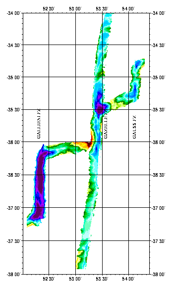
La dorsale sud-ouest indienne entre 52E et 54°30'E - 120m
Geophysical (bathymetry, gravimetry, magnetism, seismics and multichannel reflection) and geological (dredging) studies of the northern part of the Kerguelen plateau (Indian Ocean). Survey of ODP drilling sites (leg 183). The Kerguelen underwater plateau is still puzzling today, when trying to understand its origin and explain the way it was formed. To try to answer these questions, new deep ocean drilling was to be done on the Kerguelen shelf in late 1998 and early 1999.
Simple
- Date ( Creation )
- 2002-01-30
- Identifier
- IFR_MBAN_DORSALES_INDIEN_TRANSIT_52_54_BATHY_120_R
- Identifier
- DOI:10.12770/8fcbee40-a715-41be-8341-3f2f3e69e163
- Credit
- The project is part of the national program Dorsales and represents the French contribution to the InterRidge Data Banks project (see InterRidge News 1997, vol. 6/1 and 1999, vol. 8/1).
Publisher
Ifremer
+33 (0)2 98.22.46.44
http://www.ifremer.fr/sismer/
Centre IFREMER de Brest BP 70
,
PLOUZANE
,
29280
,
France
+33 (0)2 98.22.49.16
+33 (0)2 98.22.46.44
http://www.ifremer.fr/sismer/
- Thèmes Sextant Thèmes Sextant ( Theme )
-
- /Physical Environment/Bathymetry/Digital Terrain Model
- GEMET - INSPIRE themes, version 1.0 GEMET - INSPIRE themes, version 1.0 ( Theme )
-
- Elevation
- Type de jeux de donnée ODATIS Type de jeux de donnée ODATIS ( Theme )
-
- /Processed data/Composite products
- Thématiques - SIMM Thématiques - SIMM ( Theme )
-
- /Etat du Milieu/Bathymétrie
- /Etat du Milieu/Géologie
- Sous-regions marines Sous-regions marines ( Place )
-
- /Outre-mer/Océan Indien
- Thématiques - SIMM Thématiques - SIMM ( Theme )
-
- Recherche
- Use limitation
- CC-BY (Creative Commons - Attribution)
- Access constraints
- Other restrictions
- Use constraints
- License
- Other constraints
- D. Sauter, P. Patriat, C. Rommevaux-Jestin, M. Cannat, A. Briais, the Gallieni Shipboard Scientific Party, The Southwest Indian Ridge between 49˚15’E and 57˚E: focused accretion and magma redistribution, Earth Planet. Sci. Lett. 192 (2001) 303-317
- Spatial representation type
- Grid
- Denominator
- 25000
- Metadata language
- fr
- Character set
- UTF8
- Topic category
-
- Elevation
N
S
E
W
))
- Begin date
- 1995-01-01
- End date
- 1998-12-01
- Reference system identifier
- EPSG / WGS 84 (EPSG:4326) / 8.6
- Number of dimensions
- 2
- Dimension name
- Column
- Resolution
- 0.001333 degrés
- Dimension name
- Row
- Resolution
- 0.001083 degrés
- Cell geometry
- Area
- Distribution format
-
-
(
)
-
(
)
- OnLine resource
- DOI de la campagne - GALLIENI ( WWW:LINK )
- OnLine resource
- DOI de la campagne - KERIMIS ( WWW:LINK )
- OnLine resource
-
DOI du jeu de données
(
WWW:LINK-1.0-http--metadata-URL
)
DOI du jeu de données
- OnLine resource
-
IFR_MBAN_DORSALES_INDIEN_TRANSIT_52_54_BATHY_120_R
(
OGC:WMS
)
Bathymétrie à 120m de résolution
- Protocol
- FILE
- Name
- IFR_MBAN_DORSALES_INDIEN_TRANSIT_52_54_BATHY_120_R
- Description
- Bathymétrie 120m - format .tif
- Protocol
- COPYFILE
- Name
- IFR_MBAN_DORSALES_INDIEN_TRANSIT_52_54_BATHY_120_R_GRD
- Description
- Bathymétrie 120m - format .grd
- Hierarchy level
- Dataset
- Statement
- Sources : Données de la campagne J. Charcot 1988, données Seabeam
- Description
- 0 spline en tension (surface)
- Rationale
- Interpolation
Content Information
No information provided.
- File identifier
- 8fcbee40-a715-41be-8341-3f2f3e69e163 XML
- Metadata language
- fr
- Character set
- UTF8
- Hierarchy level
- Dataset
- Date stamp
- 2020-08-31T11:26:03
- Metadata standard name
- ISO 19115:2003/19139 - SEXTANT
- Metadata standard version
- 1.0
Overviews
transit52.png
Spatial extent
N
S
E
W
Provided by

Associated resources
Not available