 Mon GéoSource
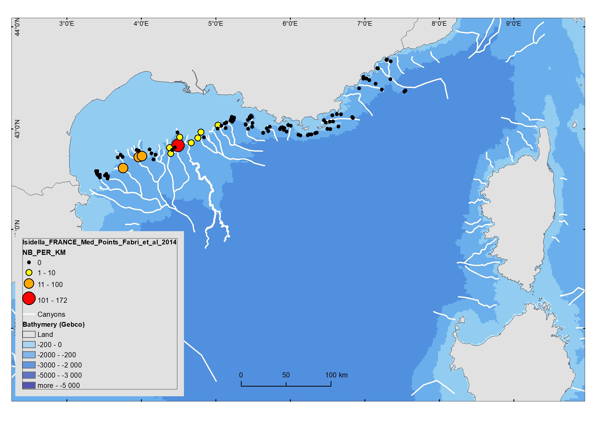
Isidella elongata (Alcyonacea) presence and absence extracted from video, from Fabri et al, 2014
Compact mud facies with Isidella elongata is a relevant habitat for red shrimps (Aristeus antennatus and Aristaeomorpha foliacea). These habitats are potentially vulnerable as they are targeted by fisheries.These VME fauna seem to have been swept away by repeated trawling.
Vulnerable Marine Ecosystems (VME) in the deep Mediterranean Sea have been identified by the General Fisheries Commission for the Mediterranean as consisting of communities of Scleractinia (Lophelia pertusa and Madrepora oculata), Pennatulacea (Funiculina quadrangularis) and Alcyonacea (Isidella elongata). This dataset concerns video data recorded in the heads of French Mediterranean canyons. Quantitative observations were extracted from 101 video films recorded during the MEDSEACAN cruise in 2009 (Aamp/Comex), in addition to 12 Ifremer dives. Species recognized in the video films were recorded from 180 to 700 m depth, and were mapped using GIS.
Isidella elongata was abundant in three canyons of the Gulf of Lion (Bourcart, Marti, Petit-Rhône).
This dataset is linked to the pulication Fabri et al, 2014. https://doi.org/10.1016/j.dsr2.2013.06.016
Simple
- Date ( Publication )
- 2020-03-02
- Identifier
- FR-330-715-368-00032-IFR_F_POINTS-ISIDELA-ELONGATA-PRES-ABS-VIDEO-GULF-OF-LION-2014
- Identifier
- DOI:10.12770/b71269cf-21d1-4d34-9ffe-25462a284f92
- Credit
- Ifremer
04 94 30 44 15
- Thèmes Sextant ( Theme )
-
- /Milieu biologique/Espèces/Espèces rares, protégées ou en voie de disparition
- GEMET - INSPIRE themes, version 1.0 ( Theme )
-
- Répartition des espèces
- DCSMM : Descripteurs ( Theme )
-
- D1: Habitats benthiques profonds (HBP)
- Sous-regions marines ( Place )
-
- /Métropole/Méditerranée occidentale
- Keywords
-
- DCSMM - Directive Cadre sur la Stratégie pour le Milieu Marin
- MSFD - Marine Strategy Framework Directive
- Habitats benthiques profonds
- VME - Vulnerable Marine Ecosystem
- Isidella elongata
- Thématiques - SIMM ( Theme )
-
- /Etat du Milieu/Espèces
- Cadre Réglementaire - SIMM ( Theme )
-
- Directive Cadre Stratégie pour le Milieu Marin (DCSMM)
- Ocean Hackathon - Ville ( Place )
-
- Toulon
- Sète
- Use limitation
- CC-BY-NC-SA (Creative Commons - Attribution, Pas d’utilisation commerciale, Partage dans les mêmes conditions)
- Access constraints
- Other restrictions
- Use constraints
- Copyright
- Other constraints
- Fabri, M.C., Pedel, L., Beuck, L., Galgani, F., Hebbeln, D., Freiwald, A., 2014. Megafauna of vulnerable marine ecosystems in French mediterranean submarine canyons: Spatial distribution and anthropogenic impacts, Deep-Sea Research Part Ii-Topical Studies in Oceanography 104, 184-207, doi: 10.1016/j.dsr2.2013.06.016.
- Spatial representation type
- Vector
- Denominator
- 2250000
- Metadata language
- fr
- Character set
- UTF8
- Topic category
-
- Biota
))
- Begin date
- 2009-01-01
- End date
- 2011-12-31T00:00:00
- Reference system identifier
- EPSG / WGS 84 (EPSG:4326) / 8.6
- Geometric object type
- Point
- Distribution format
-
-
ESRI Shapefile
(
1.0
)
-
ESRI Shapefile
(
1.0
)
- OnLine resource
-
IFR_F_POINTS-ISIDELA-ELONGATA-PRES-ABS-VIDEO-GULF-OF-LION-2014
(
OGC:WMS
)
Isidella_FRANCE_Med_GoL_Pt_from_video_Fabri_et_al_2014 (wms)
- Protocol
- FILE
- Name
- Isidella_FRANCE_Med_GoL_Pt_from_video_Fabri_et_al_2014
- Description
- Isidella_FRANCE_Med_GoL_Pt_from_video_Fabri_et_al_2014 (shape)
- OnLine resource
-
Campagne ESSROV 2010
(
WWW:LINK
)
Campagne ESSROV 2010
- OnLine resource
-
DOI du jeu de données
(
WWW:LINK-1.0-http--metadata-URL
)
DOI du jeu de données
- OnLine resource
-
DOI de la publication principale
(
WWW:LINK-1.0-http--publication-URL
)
Fabri, M.C., Pedel, L., Beuck, L., Galgani, F., Hebbeln, D., Freiwald, A., 2014. Megafauna of vulnerable marine ecosystems in French mediterranean submarine canyons: Spatial distribution and anthropogenic impacts, Deep-Sea Research Part Ii-Topical Studies in Oceanography 104, 184-207, doi: 10.1016/j.dsr2.2013.06.016
- Hierarchy level
- Dataset
Conformance result
- Date ( Publication )
- 2010-12-08
- Explanation
- See the referenced specification
- Statement
- Species distribution was mapped along dive tracks from video studies of each dive, using the Ifremer underwater vehicle data post-processing software “Adelie“ (http://www. ifremer.fr/adelie) including an extension for the ArcGIS 9.3 software suite (© ESRI).
- File identifier
- b71269cf-21d1-4d34-9ffe-25462a284f92 XML
- Metadata language
- fr
- Character set
- UTF8
- Hierarchy level
- Dataset
- Date stamp
- 2021-06-14T14:24:00
- Metadata standard name
- ISO 19115:2003/19139 - SEXTANT
- Metadata standard version
- 1.0
04 94 30 44 15
Overviews
Spatial extent
Provided by
