 Mon GéoSource
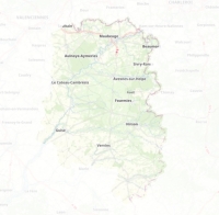
Masque autour du périmètre d'étude Sambre-Avesnois-Thiérache
Masque autour du périmètre d'étude Sambre-Avesnois-Thiérache, avec une zone tampon de 1 km autour du PNR Sambre-Avesnois.
Simple
- Date ( Creation )
- 2020-12-23
- Identifier
- https://www.geo2france.fr/2020/masque_sat
- Name
- ESRI Shapefile
- Version
- 1.0
- Keywords
-
- masque
- GEMET - INSPIRE themes, version 1.0 ( Theme )
-
- Systèmes de maillage géographique
- Départements ( Place )
-
- PAS-DE-CALAIS
- AISNE
- NORD
- Région ( Place )
-
- HAUTS-DE-FRANCE
- Use limitation
- Données ouvertes
- Spatial representation type
- Vector
- Denominator
- 5000
- Metadata language
- fr
- Character set
- UTF8
- Topic category
-
- Environment
N
S
E
W
))
- Geometric object type
- Surface
- OnLine resource
-
masque_sat
(
OGC:WMS
)
Masque Sambre Avesnois Thiérache
- OnLine resource
-
cr_hdf:masque_sat
(
OGC:WFS
)
Masque Sambre Avesnois Thiérache
- Hierarchy level
- Dataset
- Statement
- Masque calculé à partir des limites (IGN Geofla) des EPCI inclus dans le périmètre d'étude Sambre-Avesnois-Thiérache.
- File identifier
- dc3ddf1e-f1dc-4fca-b209-d82aff391f96 XML
- Metadata language
- fr
- Character set
- UTF8
- Hierarchy level
- Dataset
- Date stamp
- 2021-02-02T14:20:24
- Metadata standard name
- ISO 19115 Geographic Information - Resource
- Metadata standard version
- 2003/Cor.1:2006
Overviews
Spatial extent
N
S
E
W
Provided by

Associated resources
Not available