 Mon GéoSource
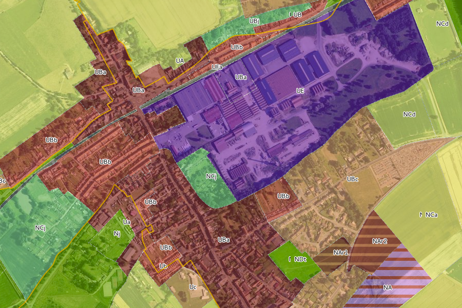
Récolement des documents d'urbanisme
Ce projet présente le plan de zonage des documents d'urbanisme communaux, il s'inscrit dans une démarche de récolement, c'est-à-dire d'une mise en compatibilité des zonages à l'échelle intercommunale les uns par rapport aux autres.
L’intérêt de la mise en place d’un zonage harmonisé des POS et PLU est de facilité la lecture et la lisibilité des règlements pour tous ceux qui ont régulièrement besoin de les consulter.
Une nomenclature commune, utilisable par toutes les communes malgré leur grande diversité a donc été élaborée pour offrir une vision homogène des différentes situations relevées localement en respectant les spécificités communales.
Cette proposition est la base d’un vocabulaire commun entre les communes. La nomenclature proposée n’est pas figée et pourra être modifiée ou réactualisée en fonction des évolutions du contexte urbain.
Simple
Information de l'identification
- Date ( Création )
- 2016-08-05T15:00:00
- Identificateur
- https://www.geo2france.fr/geonetwork/srv/fre/catalog.search#/metadata/e1f7c229-7a99-4c96-8d27-9d3dc14dc107
Contact pour la ressource
- RÈGLEMENT (CE) No 1205/2008 ( Thème )
-
- infoMapAccessService
- Mots clés ( Thème )
-
- wms 1.3.0
- Limitation d'utilisation
- Aucune condition ne s’applique
- Contraintes d'accès
- Autres restrictions
- Autres contraintes
- Pas de restriction d’accès public selon INSPIRE
- Type de service
- view
- Version du type de service
- 1.3.0
))
- Type de couplage
- Reserré
Opérations
- Nom de l’opération
- GetCapabilities
- Communication
- HTTP-GET
- Point de connection
-
Format : text/xml
(
text/xml
)
Format : text/xml
Opérations
- Nom de l’opération
- GetMap
- Communication
- HTTP-GET
- Point de connection
-
Format : image/jpeg
(
image/jpeg
)
Format : image/jpeg
- Point de connection
-
Format : image/png
(
image/png
)
Format : image/png
- Point de connection
-
Format : image/png; mode=16bit
(
image/png; mode=16bit
)
Format : image/png; mode=16bit
- Point de connection
-
Format : image/png; mode=8bit
(
image/png; mode=8bit
)
Format : image/png; mode=8bit
- Point de connection
-
Format : image/png; mode=1bit
(
image/png; mode=1bit
)
Format : image/png; mode=1bit
Opérations
- Nom de l’opération
- GetFeatureInfo
- Communication
- HTTP-GET
- Point de connection
-
Format : text/plain
(
text/plain
)
Format : text/plain
- Point de connection
-
Format : text/html
(
text/html
)
Format : text/html
- Point de connection
-
Format : text/xml
(
text/xml
)
Format : text/xml
- Point de connection
-
Format : application/vnd.ogc.gml
(
application/vnd.ogc.gml
)
Format : application/vnd.ogc.gml
- Point de connection
-
Format : application/vnd.ogc.gml/3.1.1
(
application/vnd.ogc.gml/3.1.1
)
Format : application/vnd.ogc.gml/3.1.1
Opérations
- Nom de l’opération
- sld:GetLegendGraphic
- Communication
- HTTP-GET
- Point de connection
-
Format : image/jpeg
(
image/jpeg
)
Format : image/jpeg
- Point de connection
-
Format : image/png
(
image/png
)
Format : image/png
Opérations
- Nom de l’opération
- sld:DescribeLayer
- Communication
- HTTP-GET
- Point de connection
-
Format : text/xml
(
text/xml
)
Format : text/xml
Opérations
- Nom de l’opération
- qgs:GetStyles
- Communication
- HTTP-GET
- Point de connection
-
Format : text/xml
(
text/xml
)
Format : text/xml
- Format (encodage)
-
-
(
)
-
(
)
- Ressource en ligne
-
http://carto.aduga.org/index.php/lizmap/service/?repository=urbaplanif&project=doc_urba&
(
application/vnd.ogc.wms_xml
)
http://carto.aduga.org/index.php/lizmap/service/?repository=urbaplanif&project=doc_urba&
- Ressource en ligne
-
Liens vers la fiche de métadonnées d'origine
(
WWW:LINK-1.0-http--link
)
Liens vers la fiche de métadonnées d'origine
- Ressource en ligne
- Lien vers l'application de consultation en ligne de l'ADUGA ( WWW:LINK-1.0-http--link )
- Niveau
- Service
Attributs
- Identifiant de la fiche
- e1f7c229-7a99-4c96-8d27-9d3dc14dc107 XML
- Langue
- fr
- Jeu de caractères
- Utf8
- Type de ressource
- Service
- Nom du niveau de hiérarchie
- service
- Date des métadonnées
- 2019-06-26T14:34:42
- Nom du standard de métadonnées
- ISO 19115:2003/19139
- Version du standard de métadonnées
- 1.0
Contact
Aperçus

Étendue spatiale
Fourni par
