 Mon GéoSource
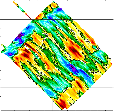
Southeast indian ridge at 27°40’S - 120m
Reconnaissance geophysique, geologique, petrographique et geochimique systematique du point triple de Rodriguez ou convergent trois dorsales medio-oceanique. Exploration geophysique, geologique, petrographiqueet geochimique d'un segment de la zone axiale de chacune des trois dorsales. Reconnaissance, dans le bassin de Wharton, d'une dorsale fossile.
Simple
- Date ( Creation )
- 1992-04-14
- Identifier
- IFR_MBAN_DORSALES_INDIEN_SEIR27_BATHY_120_R
- Identifier
- DOI:10.12770/f0ff85a1-9f28-456c-8a1b-70a3d8e93bce
- Credit
- The project is part of the national program Dorsales and represents the French contribution to the InterRidge Data Banks project (see InterRidge News 1997, vol. 6/1 and 1999, vol. 8/1).
Publisher
Ifremer
+33 (0)2 98.22.46.44
http://www.ifremer.fr/sismer/
Centre IFREMER de Brest BP 70
,
PLOUZANE
,
29280
,
France
+33 (0)2 98.22.49.16
+33 (0)2 98.22.46.44
http://www.ifremer.fr/sismer/
- Thèmes Sextant Thèmes Sextant ( Theme )
-
- /Physical Environment/Bathymetry/Digital Terrain Model
- GEMET - INSPIRE themes, version 1.0 GEMET - INSPIRE themes, version 1.0 ( Theme )
-
- Elevation
- Type de jeux de donnée ODATIS Type de jeux de donnée ODATIS ( Theme )
-
- /Processed data/Composite products
- Thématiques - SIMM Thématiques - SIMM ( Theme )
-
- /Etat du Milieu/Géologie
- /Etat du Milieu/Bathymétrie
- Sous-regions marines Sous-regions marines ( Place )
-
- /Outre-mer/Océan Indien
- Thématiques - SIMM Thématiques - SIMM ( Theme )
-
- Recherche
- Use limitation
- CC-BY (Creative Commons - Attribution)
- Access constraints
- Other restrictions
- Use constraints
- License
- Other constraints
- Sauter D., Whitechurch H., Munschy M. and Humler E., 1991 - Periodicity in the accretion process on the Southeast Indian Ridge at 27˚40'S. Tectonophysics, 195, p. 47-64.
- Spatial representation type
- Grid
- Denominator
- 25000
- Metadata language
- fr
- Character set
- UTF8
- Topic category
-
- Elevation
N
S
E
W
))
- Reference system identifier
- EPSG / WGS 84 (EPSG:4326) / 8.6
- Number of dimensions
- 2
- Dimension name
- Column
- Resolution
- 0.00122 degres
- Dimension name
- Row
- Resolution
- 0.001079 degres
- Cell geometry
- Area
- Distribution format
-
-
(
)
-
(
)
- OnLine resource
- DOI de la campagne - RODRIGUEZ(1ER LEG) ( WWW:LINK )
- OnLine resource
- DOI de la campagne - RODRIGUEZ(2EME LEG) ( WWW:LINK )
- OnLine resource
-
DOI du jeu de données
(
WWW:LINK-1.0-http--metadata-URL
)
DOI du jeu de données
- OnLine resource
-
IFR_MBAN_DORSALES_INDIEN_SEIR27_BATHY_120_R
(
OGC:WMS
)
Bathymétrie à 120m de résolution
- Protocol
- FILE
- Name
- IFR_MBAN_DORSALES_INDIEN_SEIR27_BATHY_120_R
- Description
- Bathymétrie 120m - format .tif
- Protocol
- COPYFILE
- Name
- IFR_MBAN_DORSALES_INDIEN_SEIR27_BATHY_120_R_GRD
- Description
- Bathymétrie 120m - format .grd
- Hierarchy level
- Dataset
- Statement
- Sources : Données de la campagne J. Charcot 1988, données Seabeam
- Description
- 0 spline en tension (surface)
- Rationale
- Interpolation
Content Information
No information provided.
- File identifier
- f0ff85a1-9f28-456c-8a1b-70a3d8e93bce XML
- Metadata language
- fr
- Character set
- UTF8
- Hierarchy level
- Dataset
- Date stamp
- 2020-08-31T11:24:30
- Metadata standard name
- ISO 19115:2003/19139 - SEXTANT
- Metadata standard version
- 1.0
Overviews
Capture.PNG
Spatial extent
N
S
E
W
Provided by

Associated resources
Not available